Longmont Topo Map Colorado
To zoom in, hover over the map of Longmont
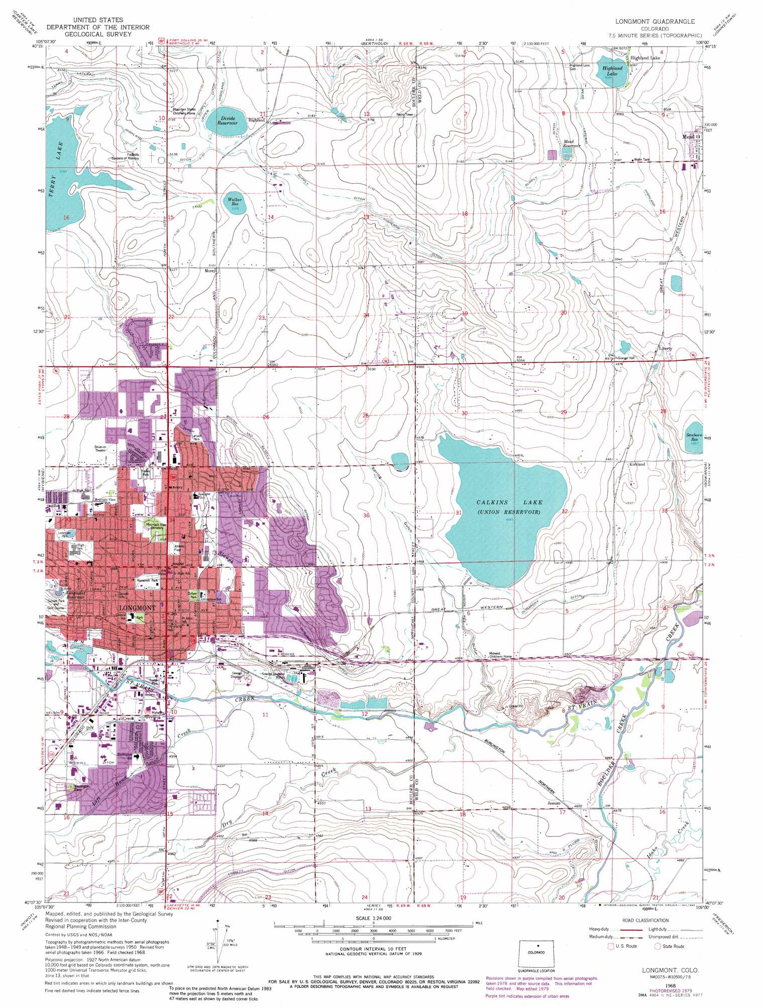
USGS Topo Quad 40105b1 - 1:24,000 scale
| Topo Map Name: | Longmont |
| USGS Topo Quad ID: | 40105b1 |
| Print Size: | ca. 21 1/4" wide x 27" high |
| Southeast Coordinates: | 40.125° N latitude / 105° W longitude |
| Map Center Coordinates: | 40.1875° N latitude / 105.0625° W longitude |
| U.S. State: | CO |
| Filename: | o40105b1.jpg |
| Download Map JPG Image: | Longmont topo map 1:24,000 scale |
| Map Type: | Topographic |
| Topo Series: | 7.5´ |
| Map Scale: | 1:24,000 |
| Source of Map Images: | United States Geological Survey (USGS) |
| Alternate Map Versions: |
Longmont CO 1950, updated 1960 Download PDF Buy paper map Longmont CO 1950, updated 1963 Download PDF Buy paper map Longmont CO 1951 Download PDF Buy paper map Longmont CO 1968, updated 1968 Download PDF Buy paper map Longmont CO 1968, updated 1968 Download PDF Buy paper map Longmont CO 1968, updated 1973 Download PDF Buy paper map Longmont CO 1968, updated 1973 Download PDF Buy paper map Longmont CO 1968, updated 1980 Download PDF Buy paper map Longmont CO 1968, updated 1983 Download PDF Buy paper map Longmont CO 2010 Download PDF Buy paper map Longmont CO 2013 Download PDF Buy paper map Longmont CO 2016 Download PDF Buy paper map |
1:24,000 Topo Quads surrounding Longmont
Drake |
Masonville |
Loveland |
Windsor |
Bracewell |
Pinewood Lake |
Carter Lake Reservoir |
Berthoud |
Johnstown |
Milliken |
Lyons |
Hygiene |
Longmont |
Gowanda |
Platteville |
Boulder |
Niwot |
Erie |
Frederick |
Fort Lupton |
Eldorado Springs |
Louisville |
Lafayette |
Eastlake |
Brighton |
> Back to 40105a1 at 1:100,000 scale
> Back to 40104a1 at 1:250,000 scale
> Back to U.S. Topo Maps home
Longmont topo map: Gazetteer
Longmont: Airports
Cartwheel Airport elevation 1524m 5000′Longmont: Canals
Oligarchy Ditch elevation 1532m 5026′Union Reservoir Ditch elevation 1500m 4921′
Wiswall Ditch elevation 1519m 4983′
Longmont: Dams
Calkins Dam elevation 1523m 4996′Divide Dam elevation 1563m 5127′
Highland Dam elevation 1544m 5065′
Logan Dam elevation 1532m 5026′
Mead Dam elevation 1563m 5127′
Pleasant Valley Dam elevation 1553m 5095′
Sanborn Dam elevation 1510m 4954′
Union Dam elevation 1511m 4957′
Walker Dam elevation 1557m 5108′
Longmont: Mines
Button R Dam Mine elevation 1519m 4983′Helmer Brothers Pit elevation 1523m 4996′
Longmont Plant Pit elevation 1519m 4983′
Mountain Aggregates Pit elevation 1519m 4983′
Phil G Skrbina Pit elevation 1519m 4983′
South Flat Pit elevation 1519m 4983′
Longmont: Parks
Collyer Park elevation 1520m 4986′Lanyon Park elevation 1532m 5026′
Loomiller Park elevation 1527m 5009′
Roosevelt Park elevation 1522m 4993′
Longmont: Populated Places
Highland elevation 1566m 5137′Highland Lake elevation 1545m 5068′
Jessum elevation 1492m 4895′
Kirkland elevation 1507m 4944′
Liberty elevation 1521m 4990′
Longmont elevation 1519m 4983′
Morey elevation 1556m 5104′
Longmont: Reservoirs
Calkins Lake elevation 1511m 4957′Calkins Reservoir elevation 1523m 4996′
Divide Reservoir elevation 1563m 5127′
Highland Lake elevation 1545m 5068′
Highland Reservoir elevation 1544m 5065′
Logan Reservoir elevation 1532m 5026′
Longmont Reservoir elevation 1551m 5088′
Mead Reservoir elevation 1559m 5114′
Pleasant Valley Reservoir elevation 1553m 5095′
Sanborn Reservoir elevation 1510m 4954′
Town of Mead Reservoir elevation 1563m 5127′
Union Reservoir elevation 1511m 4957′
Walker Reservoir elevation 1557m 5108′
Longmont: Streams
Boulder Creek elevation 1479m 4852′Dry Creek elevation 1488m 4881′
Dry Creek elevation 1506m 4940′
Left Hand Creek elevation 1501m 4924′
The Slough elevation 1502m 4927′
Longmont: Valleys
Spring Gulch elevation 1491m 4891′Longmont digital topo map on disk
Buy this Longmont topo map showing relief, roads, GPS coordinates and other geographical features, as a high-resolution digital map file on DVD: