Gowanda Topo Map Colorado
To zoom in, hover over the map of Gowanda
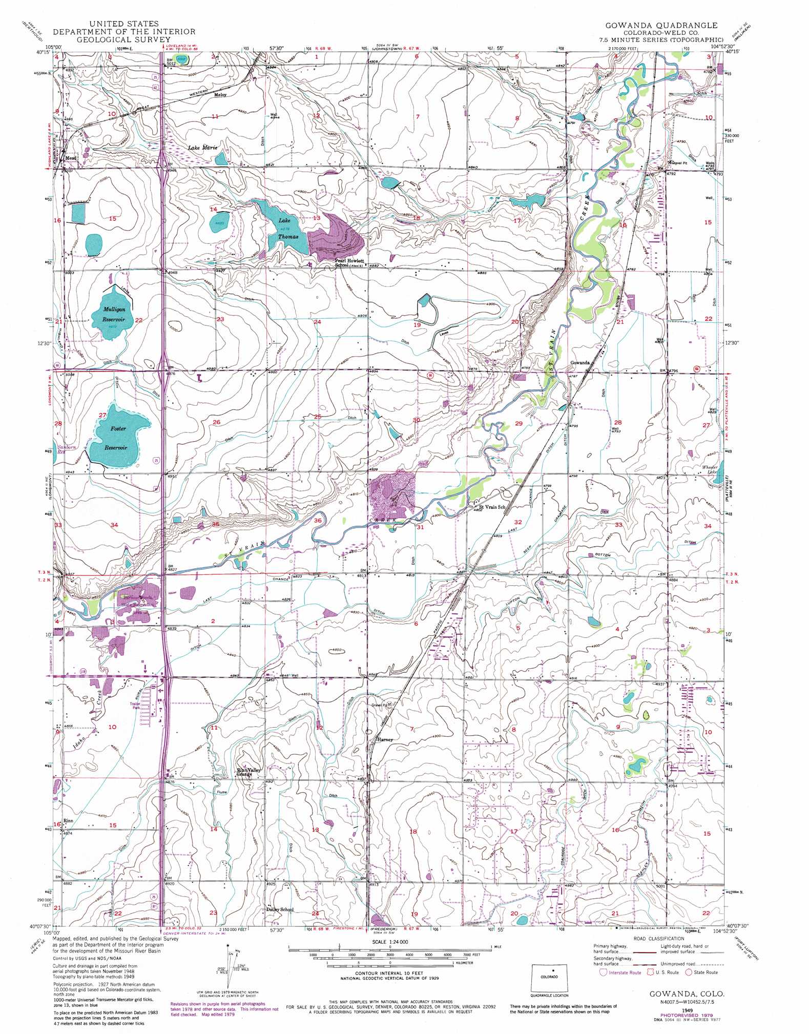
USGS Topo Quad 40104b8 - 1:24,000 scale
| Topo Map Name: | Gowanda |
| USGS Topo Quad ID: | 40104b8 |
| Print Size: | ca. 21 1/4" wide x 27" high |
| Southeast Coordinates: | 40.125° N latitude / 104.875° W longitude |
| Map Center Coordinates: | 40.1875° N latitude / 104.9375° W longitude |
| U.S. State: | CO |
| Filename: | o40104b8.jpg |
| Download Map JPG Image: | Gowanda topo map 1:24,000 scale |
| Map Type: | Topographic |
| Topo Series: | 7.5´ |
| Map Scale: | 1:24,000 |
| Source of Map Images: | United States Geological Survey (USGS) |
| Alternate Map Versions: |
Gowanda CO 1949, updated 1957 Download PDF Buy paper map Gowanda CO 1949, updated 1970 Download PDF Buy paper map Gowanda CO 1949, updated 1970 Download PDF Buy paper map Gowanda CO 1949, updated 1980 Download PDF Buy paper map Gowanda CO 1949, updated 1983 Download PDF Buy paper map Gowanda CO 1950 Download PDF Buy paper map Gowanda CO 2010 Download PDF Buy paper map Gowanda CO 2013 Download PDF Buy paper map Gowanda CO 2016 Download PDF Buy paper map |
1:24,000 Topo Quads surrounding Gowanda
Masonville |
Loveland |
Windsor |
Bracewell |
Greeley |
Carter Lake Reservoir |
Berthoud |
Johnstown |
Milliken |
La Salle |
Hygiene |
Longmont |
Gowanda |
Platteville |
Milton Reservoir |
Niwot |
Erie |
Frederick |
Fort Lupton |
Hudson |
Louisville |
Lafayette |
Eastlake |
Brighton |
Mile High Lakes |
> Back to 40104a1 at 1:100,000 scale
> Back to 40104a1 at 1:250,000 scale
> Back to U.S. Topo Maps home
Gowanda topo map: Gazetteer
Gowanda: Airports
Ag-Air Incorporated Heliport elevation 1523m 4996′Carrera Airpark elevation 1501m 4924′
Frontier Airstrip elevation 1519m 4983′
Rancho De Aereo Airport elevation 1517m 4977′
Gowanda: Canals
Coal Ridge Ditch elevation 1512m 4960′Last Chance Ditch elevation 1470m 4822′
Rural Ditch elevation 1483m 4865′
Gowanda: Dams
B L Swift Dam elevation 1458m 4783′Bass Dam elevation 1481m 4858′
Diamond Dam elevation 1458m 4783′
Highland Number 1 Dam elevation 1517m 4977′
Highland Number 3 Dam elevation 1509m 4950′
Holt Dam elevation 1501m 4924′
Mulligan Dam elevation 1516m 4973′
New Thomas Dam elevation 1489m 4885′
Sullivan Dam elevation 1475m 4839′
Gowanda: Mines
Gentry Mine elevation 1516m 4973′Little Ash Mine elevation 1516m 4973′
Gowanda: Populated Places
Gowanda elevation 1461m 4793′Harney elevation 1491m 4891′
Maloy elevation 1516m 4973′
Mead elevation 1525m 5003′
Rinn elevation 1486m 4875′
Gowanda: Reservoirs
B L Swift Reservoir elevation 1458m 4783′Bass Reservoir elevation 1481m 4858′
Diamond Reservoir elevation 1458m 4783′
Foster Reservoir elevation 1509m 4950′
Highland Reservoir Number 1 elevation 1517m 4977′
Highland Reservoir Number 3 elevation 1509m 4950′
Holt Reservoir elevation 1501m 4924′
Lake Marie elevation 1498m 4914′
Lake Thomas elevation 1486m 4875′
McKay Reservoir elevation 1530m 5019′
Mulligan Reservoir elevation 1516m 4973′
New Thomas Reservoir elevation 1489m 4885′
Sullivan Reservoir elevation 1475m 4839′
Gowanda: Streams
Idaho Creek elevation 1473m 4832′Gowanda digital topo map on disk
Buy this Gowanda topo map showing relief, roads, GPS coordinates and other geographical features, as a high-resolution digital map file on DVD: