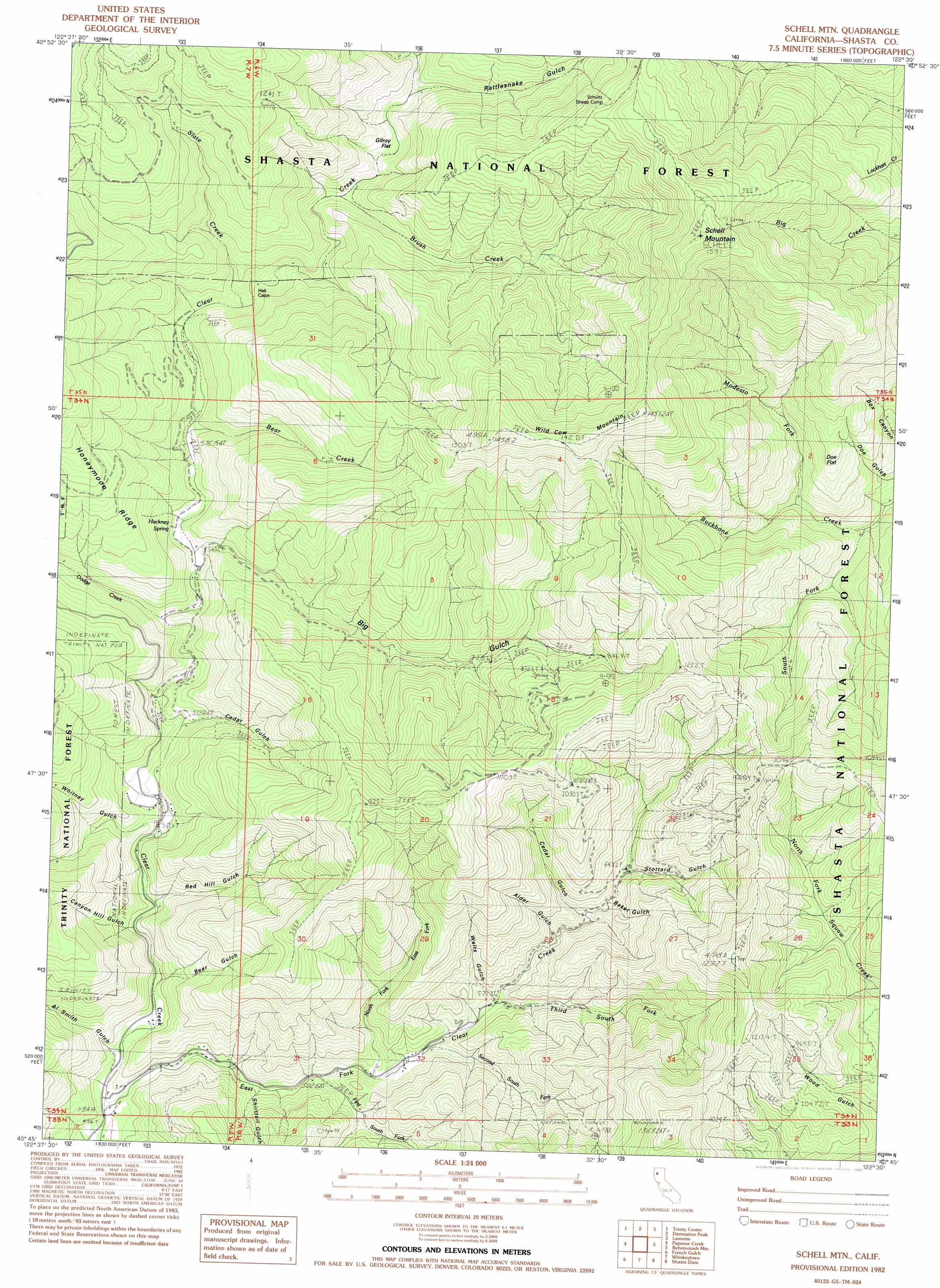
Schell Mountain Topo Map California
To zoom in, hover over the map of Schell Mountain
USGS Topo Quad 40122g5 - 1:24,000 scale
| Topo Map Name: | Schell Mountain |
| USGS Topo Quad ID: | 40122g5 |
| Print Size: | ca. 21 1/4" wide x 27" high |
| Southeast Coordinates: | 40.75° N latitude / 122.5° W longitude |
| Map Center Coordinates: | 40.8125° N latitude / 122.5625° W longitude |
| U.S. State: | CA |
| Filename: | o40122g5.jpg |
| Download Map JPG Image: | Schell Mountain topo map 1:24,000 scale |
| Map Type: | Topographic |
| Topo Series: | 7.5´ |
| Map Scale: | 1:24,000 |
| Source of Map Images: | United States Geological Survey (USGS) |
| Alternate Map Versions: |
Schell Mtn CA 1982, updated 1982 Download PDF Buy paper map Schell Mountain CA 1998, updated 2003 Download PDF Buy paper map Schell Mountain CA 2012 Download PDF Buy paper map Schell Mountain CA 2015 Download PDF Buy paper map |
| FStopo: | US Forest Service topo Schell Mountain is available: Download FStopo PDF Download FStopo TIF |
1:24,000 Topo Quads surrounding Schell Mountain
Ycatapom Peak |
Carrville |
Whisky Bill Peak |
Chicken Hawk Hill |
Tombstone Mountain |
Covington Mill |
Trinity Center |
Damnation Peak |
Lamoine |
Hanland Peak |
Trinity Dam |
Papoose Creek |
Schell Mountain |
Bohemotash Mountain |
O'Brien |
Lewiston |
French Gulch |
Whiskeytown |
Shasta Dam |
Project City |
Bully Choop Mountain |
Shasta Bally |
Igo |
Redding |
Enterprise |
> Back to 40122e1 at 1:100,000 scale
> Back to 40122a1 at 1:250,000 scale
> Back to U.S. Topo Maps home
Schell Mountain topo map: Gazetteer
Schell Mountain: Flats
Doe Flat elevation 747m 2450′Gilroy Flat elevation 726m 2381′
Schell Mountain: Mines
Baker Mine elevation 871m 2857′Schell Mountain: Ridges
Honeymoon Ridge elevation 1098m 3602′Schell Mountain: Springs
Hackney Spring elevation 591m 1938′Schell Mountain: Streams
Bear Creek elevation 583m 1912′Brush Creek elevation 709m 2326′
Dodge Creek elevation 574m 1883′
First South Fork East Fork Clear Creek elevation 509m 1669′
Modesto Fork elevation 568m 1863′
North Fork East Fork Clear Creek elevation 516m 1692′
Second South Fork East Fork Clear Creek elevation 538m 1765′
Slate Creek elevation 623m 2043′
South Fork Backbone Creek elevation 520m 1706′
Third South Fork East Fork Clear Creek elevation 555m 1820′
Whitney Creek elevation 500m 1640′
Schell Mountain: Summits
Schell Mountain elevation 1580m 5183′Wild Cow Mountain elevation 1485m 4872′
Schell Mountain: Valleys
Al Smith Gulch elevation 481m 1578′Alder Gulch elevation 599m 1965′
Baker Gulch elevation 624m 2047′
Bear Gulch elevation 475m 1558′
Big Gulch elevation 568m 1863′
Canyon Hill Gulch elevation 504m 1653′
Cedar Gulch elevation 967m 3172′
Cedar Gulch elevation 643m 2109′
Cosy Dell elevation 514m 1686′
Rattlesnake Gulch elevation 780m 2559′
Red Hill Gulch elevation 494m 1620′
Shirttail Gulch elevation 520m 1706′
Stottard Gulch elevation 652m 2139′
Walts Gulch elevation 560m 1837′
Whitney Gulch elevation 561m 1840′
Schell Mountain digital topo map on disk
Buy this Schell Mountain topo map showing relief, roads, GPS coordinates and other geographical features, as a high-resolution digital map file on DVD: