Tobyhanna Topo Map Pennsylvania
To zoom in, hover over the map of Tobyhanna
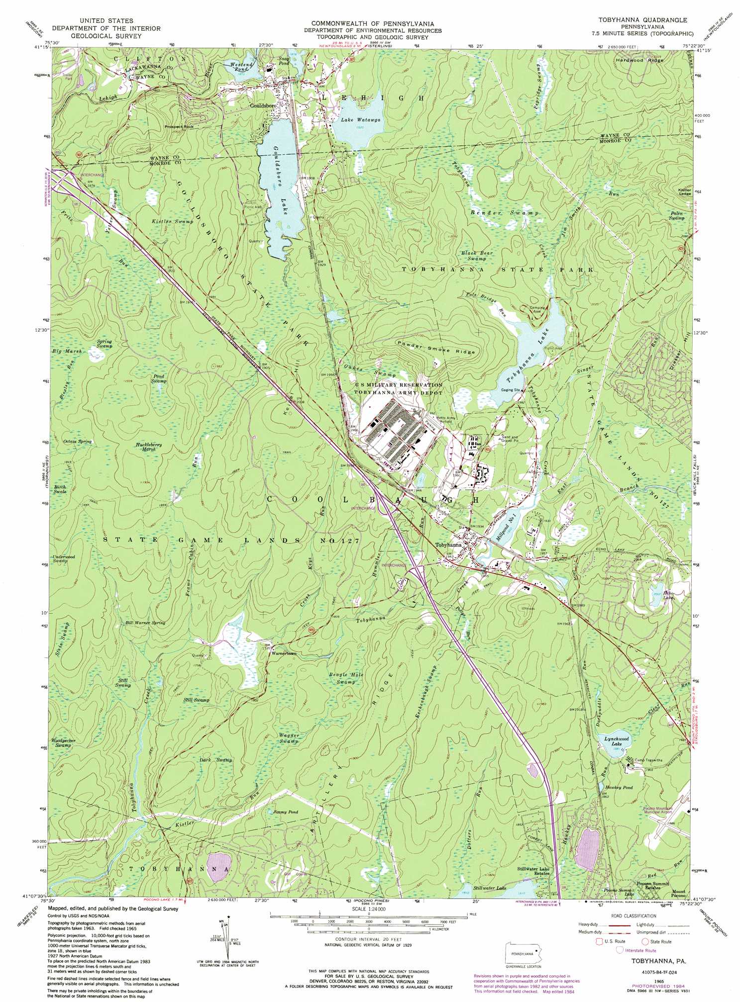
USGS Topo Quad 41075b4 - 1:24,000 scale
| Topo Map Name: | Tobyhanna |
| USGS Topo Quad ID: | 41075b4 |
| Print Size: | ca. 21 1/4" wide x 27" high |
| Southeast Coordinates: | 41.125° N latitude / 75.375° W longitude |
| Map Center Coordinates: | 41.1875° N latitude / 75.4375° W longitude |
| U.S. State: | PA |
| Filename: | o41075b4.jpg |
| Download Map JPG Image: | Tobyhanna topo map 1:24,000 scale |
| Map Type: | Topographic |
| Topo Series: | 7.5´ |
| Map Scale: | 1:24,000 |
| Source of Map Images: | United States Geological Survey (USGS) |
| Alternate Map Versions: |
Tobyhanna PA 1965, updated 1967 Download PDF Buy paper map Tobyhanna PA 1965, updated 1973 Download PDF Buy paper map Tobyhanna PA 1965, updated 1984 Download PDF Buy paper map Tobyhanna PA 1976, updated 1978 Download PDF Buy paper map Tobyhanna PA 1994, updated 1996 Download PDF Buy paper map Tobyhanna PA 1999, updated 2002 Download PDF Buy paper map Tobyhanna PA 2010 Download PDF Buy paper map Tobyhanna PA 2013 Download PDF Buy paper map Tobyhanna PA 2016 Download PDF Buy paper map |
1:24,000 Topo Quads surrounding Tobyhanna
Scranton |
Olyphant |
Lake Ariel |
Lakeville |
Hawley |
Avoca |
Moscow |
Sterling |
Newfoundland |
Promised Land |
Pleasant View Summit |
Thornhurst |
Tobyhanna |
Buck Hill Falls |
Skytop |
Hickory Run |
Blakeslee |
Pocono Pines |
Mount Pocono |
East Stroudsburg |
Christmans |
Pohopoco Mountain |
Brodheadsville |
Saylorsburg |
Stroudsburg |
> Back to 41075a1 at 1:100,000 scale
> Back to 41074a1 at 1:250,000 scale
> Back to U.S. Topo Maps home
Tobyhanna topo map: Gazetteer
Tobyhanna: Dams
Gouldsboro Dam elevation 609m 1998′Gouldsoro Dam elevation 598m 1961′
Lake Lehigh Dam elevation 574m 1883′
Lake Watawga Dam elevation 585m 1919′
Lynchwood Dam elevation 573m 1879′
Tobyhanna Number Two Dam elevation 597m 1958′
Tobyhanna: Lakes
Echo Lake elevation 611m 2004′Hawkey Pond elevation 563m 1847′
Ice Pond elevation 534m 1751′
Jimmy Pond elevation 567m 1860′
Tobyhanna Lake elevation 597m 1958′
Tobyhanna: Parks
Gouldsboro State Park elevation 582m 1909′State Game Lands Number 127 elevation 567m 1860′
Tobyhanna: Populated Places
Gouldsboro elevation 581m 1906′Tobyhanna elevation 591m 1938′
Warnertown elevation 543m 1781′
Tobyhanna: Reservoirs
Gouldsboro Lake elevation 579m 1899′Lake Lehigh elevation 574m 1883′
Lake Watawga elevation 585m 1919′
Lynchwood Lake elevation 573m 1879′
Millpond Number One elevation 584m 1916′
Stillwater Lake elevation 552m 1811′
Westend Pond elevation 571m 1873′
Tobyhanna: Ridges
Hardwood Ridge elevation 679m 2227′Powder Smoke Ridge elevation 646m 2119′
Tobyhanna: Springs
Bill Warner Spring elevation 529m 1735′Octave Spring elevation 572m 1876′
Tobyhanna: Streams
Clear Run elevation 576m 1889′Cross Keys Run elevation 536m 1758′
Dotters Run elevation 554m 1817′
Dresser Run elevation 597m 1958′
Duckpuddle Run elevation 573m 1879′
East Branch Tobyhanna Creek elevation 583m 1912′
Frame Cabin Run elevation 523m 1715′
Hawkey Run elevation 552m 1811′
Hummler Run elevation 555m 1820′
Jim Smith Run elevation 597m 1958′
Kistler Run elevation 510m 1673′
Pole Bridge Run elevation 597m 1958′
Pollys Run elevation 573m 1879′
Red Run elevation 557m 1827′
Singer Run elevation 589m 1932′
Tobyhanna: Summits
Keipel Hill elevation 610m 2001′Prospect Rock elevation 623m 2043′
Tobyhanna: Swamps
Beagle Hole Swamp elevation 560m 1837′Bender Swamp elevation 605m 1984′
Birch Swale elevation 564m 1850′
Black Bear Swamp elevation 604m 1981′
Dark Swamp elevation 542m 1778′
Eschenbaugh Swamp elevation 583m 1912′
Huckleberry Marsh elevation 582m 1909′
Kistler Swamp elevation 584m 1916′
Oakes Swamp elevation 597m 1958′
Palen Swamp elevation 639m 2096′
Pepridge Swamp elevation 626m 2053′
Pond Swamp elevation 583m 1912′
Spring Swamp elevation 571m 1873′
Stein Swamp elevation 547m 1794′
Still Swamp elevation 527m 1729′
Wagner Swamp elevation 553m 1814′
Woodpecker Swamp elevation 533m 1748′
Yetter Swamp elevation 573m 1879′
Tobyhanna: Trails
Lakeside Trail elevation 601m 1971′Tobyhanna digital topo map on disk
Buy this Tobyhanna topo map showing relief, roads, GPS coordinates and other geographical features, as a high-resolution digital map file on DVD:
New York, Vermont, Connecticut & Western Massachusetts
Buy digital topo maps: New York, Vermont, Connecticut & Western Massachusetts