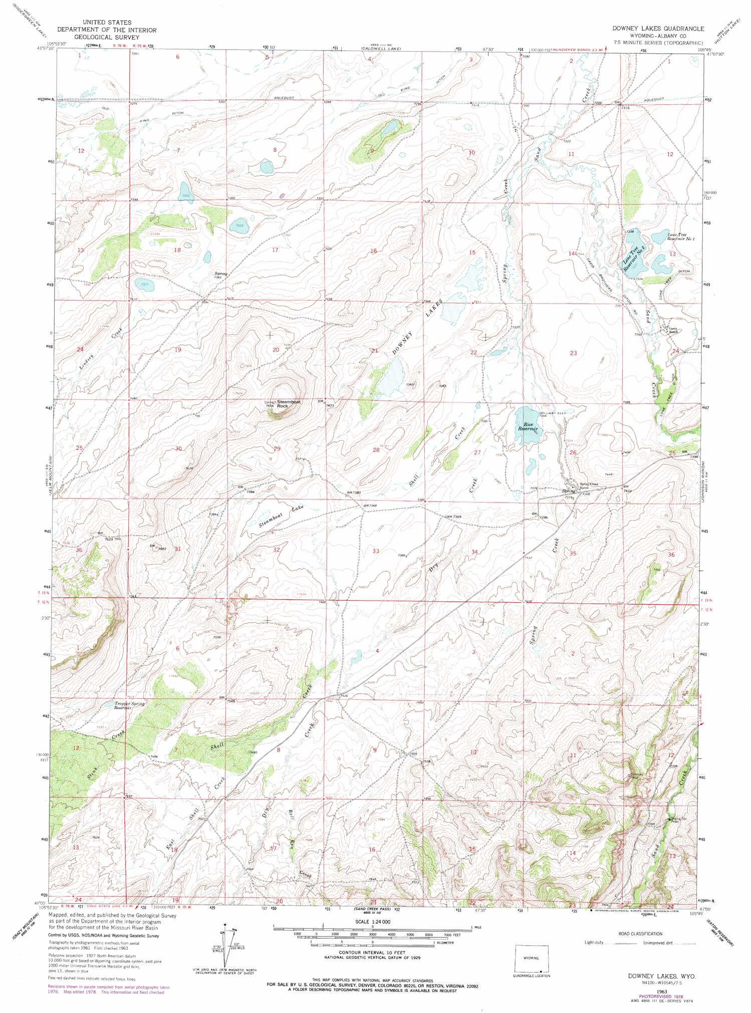
Downey Lakes Topo Map Wyoming
To zoom in, hover over the map of Downey Lakes
USGS Topo Quad 41105a7 - 1:24,000 scale
| Topo Map Name: | Downey Lakes |
| USGS Topo Quad ID: | 41105a7 |
| Print Size: | ca. 21 1/4" wide x 27" high |
| Southeast Coordinates: | 41° N latitude / 105.75° W longitude |
| Map Center Coordinates: | 41.0625° N latitude / 105.8125° W longitude |
| U.S. State: | WY |
| Filename: | o41105a7.jpg |
| Download Map JPG Image: | Downey Lakes topo map 1:24,000 scale |
| Map Type: | Topographic |
| Topo Series: | 7.5´ |
| Map Scale: | 1:24,000 |
| Source of Map Images: | United States Geological Survey (USGS) |
| Alternate Map Versions: |
Downey Lakes WY 1963, updated 1965 Download PDF Buy paper map Downey Lakes WY 1963, updated 1978 Download PDF Buy paper map Downey Lakes WY 2012 Download PDF Buy paper map Downey Lakes WY 2015 Download PDF Buy paper map |
1:24,000 Topo Quads surrounding Downey Lakes
Rex Lake |
Millbrook |
La Marsh Creek West |
Laramie Sw |
Laramie |
Lake Owen |
Sodergreen Lake |
Caldwell Lake |
Hutton Lake |
Red Buttes |
Woods Landing |
Jelm Mountain |
Downey Lakes |
Johnson Ranch |
Best Ranch |
Old Roach |
Crazy Mountain |
Sand Creek Pass |
Eaton Reservoir |
Diamond Peak |
Shipman Mountain |
Glendevey |
Deadman |
South Bald Mountain |
Red Feather Lakes |
> Back to 41105a1 at 1:100,000 scale
> Back to 41104a1 at 1:250,000 scale
> Back to U.S. Topo Maps home
Downey Lakes topo map: Gazetteer
Downey Lakes: Canals
Davis Brothers Ditch Number 1 elevation 2239m 7345′Lone Tree Ditch elevation 2241m 7352′
Downey Lakes: Dams
Lone Tree Number 1 Dam elevation 2242m 7355′Downey Lakes: Lakes
Downey Lakes elevation 2228m 7309′Steamboat Lake elevation 2240m 7349′
Downey Lakes: Mines
Middle Downey Lake Mine elevation 2239m 7345′North Downey Lake Mine elevation 2229m 7312′
Riverside Ranch Mine elevation 2233m 7326′
South Downey Lake Mine elevation 2228m 7309′
Downey Lakes: Reservoirs
Lone Tree Number 1 Reservoir elevation 2242m 7355′Lone Tree Reservoir Number 1 elevation 2240m 7349′
Lone Tree Reservoir Number 2 elevation 2236m 7335′
Rice Reservoir elevation 2240m 7349′
Trapper Spring Reservoir elevation 2289m 7509′
Downey Lakes: Streams
Bull Run Creek elevation 2285m 7496′Dry Creek elevation 2241m 7352′
Dry Creek elevation 2235m 7332′
East Shell Creek elevation 2275m 7463′
East Shell Creek elevation 2276m 7467′
Lindsey Creek elevation 2255m 7398′
Sand Creek elevation 2229m 7312′
Shell Creek elevation 2235m 7332′
Shell Creek elevation 2240m 7349′
Spring Creek elevation 2221m 7286′
Stink Creek elevation 2276m 7467′
Stink Creek elevation 2276m 7467′
Downey Lakes: Summits
Steamboat Rock elevation 2323m 7621′Downey Lakes digital topo map on disk
Buy this Downey Lakes topo map showing relief, roads, GPS coordinates and other geographical features, as a high-resolution digital map file on DVD:
Eastern Wyoming & Western South Dakota
Buy digital topo maps: Eastern Wyoming & Western South Dakota