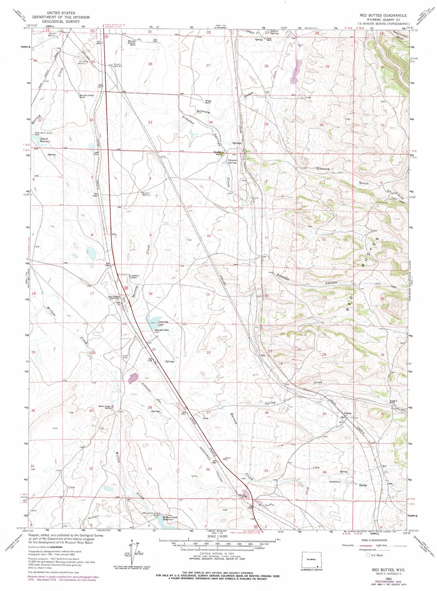
Red Buttes Topo Map Wyoming
To zoom in, hover over the map of Red Buttes
USGS Topo Quad 41105b5 - 1:24,000 scale
| Topo Map Name: | Red Buttes |
| USGS Topo Quad ID: | 41105b5 |
| Print Size: | ca. 21 1/4" wide x 27" high |
| Southeast Coordinates: | 41.125° N latitude / 105.5° W longitude |
| Map Center Coordinates: | 41.1875° N latitude / 105.5625° W longitude |
| U.S. State: | WY |
| Filename: | o41105b5.jpg |
| Download Map JPG Image: | Red Buttes topo map 1:24,000 scale |
| Map Type: | Topographic |
| Topo Series: | 7.5´ |
| Map Scale: | 1:24,000 |
| Source of Map Images: | United States Geological Survey (USGS) |
| Alternate Map Versions: |
Red Buttes WY 1963, updated 1965 Download PDF Buy paper map Red Buttes WY 1963, updated 1978 Download PDF Buy paper map Red Buttes WY 2012 Download PDF Buy paper map Red Buttes WY 2015 Download PDF Buy paper map |
1:24,000 Topo Quads surrounding Red Buttes
Alsop Lake |
Bamforth Lake |
Howell |
King Mountain |
Ragged Top Mountain |
La Marsh Creek West |
Laramie Sw |
Laramie |
Pilot Hill |
Green Top Mountain |
Caldwell Lake |
Hutton Lake |
Red Buttes |
Sherman Mountains West |
Sherman Mountains East |
Downey Lakes |
Johnson Ranch |
Best Ranch |
Dale Creek |
Buford |
Sand Creek Pass |
Eaton Reservoir |
Diamond Peak |
Cherokee Park |
Virginia Dale |
> Back to 41105a1 at 1:100,000 scale
> Back to 41104a1 at 1:250,000 scale
> Back to U.S. Topo Maps home
Red Buttes topo map: Gazetteer
Red Buttes: Dams
Harney Creek Dam elevation 2262m 7421′Hundred Springs Dam elevation 2233m 7326′
Red Buttes: Lakes
Leazenby Lake elevation 2232m 7322′Red Buttes: Mines
Harney Creek Valley Mine elevation 2237m 7339′Red Buttes: Populated Places
Red Buttes elevation 2231m 7319′The Buttes elevation 2256m 7401′
Red Buttes: Reservoirs
Goforth Reservoir elevation 2203m 7227′Harney Creek Reservoir elevation 2262m 7421′
Hundred Springs Reservoir elevation 2233m 7326′
Willow Creek Reservoir elevation 2261m 7417′
Red Buttes: Springs
Simpson Springs elevation 2238m 7342′Soldier Spring elevation 2232m 7322′
Red Buttes: Streams
Simpson Springs Creek elevation 2201m 7221′Spring Creek elevation 2257m 7404′
Red Buttes: Summits
Red Buttes elevation 2360m 7742′Red Buttes: Valleys
Dry Gulch elevation 2347m 7700′Gilmore Gulch elevation 2201m 7221′
Sawmill Canyon elevation 2299m 7542′
Red Buttes: Wells
Monolith Well Number 1 elevation 2191m 7188′Monolith Well Number 3 elevation 2223m 7293′
Monolith Well Number 5 elevation 2195m 7201′
Monolith Well Number 7 elevation 2202m 7224′
Red Buttes digital topo map on disk
Buy this Red Buttes topo map showing relief, roads, GPS coordinates and other geographical features, as a high-resolution digital map file on DVD:
Eastern Wyoming & Western South Dakota
Buy digital topo maps: Eastern Wyoming & Western South Dakota