Lake Owen Topo Map Wyoming
To zoom in, hover over the map of Lake Owen
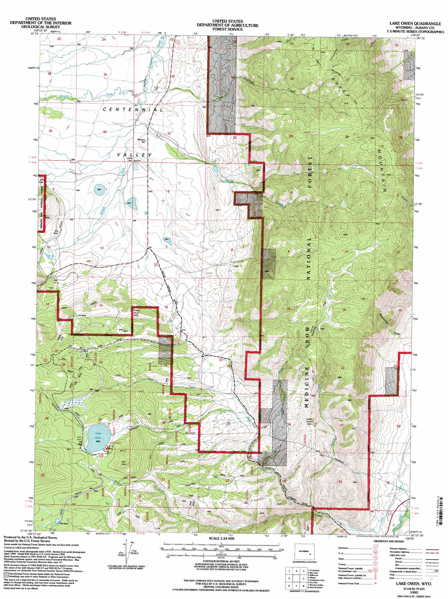
USGS Topo Quad 41106b1 - 1:24,000 scale
| Topo Map Name: | Lake Owen |
| USGS Topo Quad ID: | 41106b1 |
| Print Size: | ca. 21 1/4" wide x 27" high |
| Southeast Coordinates: | 41.125° N latitude / 106° W longitude |
| Map Center Coordinates: | 41.1875° N latitude / 106.0625° W longitude |
| U.S. State: | WY |
| Filename: | o41106b1.jpg |
| Download Map JPG Image: | Lake Owen topo map 1:24,000 scale |
| Map Type: | Topographic |
| Topo Series: | 7.5´ |
| Map Scale: | 1:24,000 |
| Source of Map Images: | United States Geological Survey (USGS) |
| Alternate Map Versions: |
Lake Owen WY 1961, updated 1963 Download PDF Buy paper map Lake Owen WY 1961, updated 1966 Download PDF Buy paper map Lake Owen WY 1961, updated 1984 Download PDF Buy paper map Lake Owen WY 1992, updated 1996 Download PDF Buy paper map Lake Owen WY 2012 Download PDF Buy paper map Lake Owen WY 2015 Download PDF Buy paper map |
| FStopo: | US Forest Service topo Lake Owen is available: Download FStopo PDF Download FStopo TIF |
1:24,000 Topo Quads surrounding Lake Owen
Sand Lake |
Morgan |
Strouss Hill |
James Lake |
Alsop Lake |
Medicine Bow Peak |
Centennial |
Rex Lake |
Millbrook |
La Marsh Creek West |
Keystone |
Albany |
Lake Owen |
Sodergreen Lake |
Caldwell Lake |
Horatio Rock |
Foxpark |
Woods Landing |
Jelm Mountain |
Downey Lakes |
Northgate |
Kings Canyon |
Old Roach |
Crazy Mountain |
Sand Creek Pass |
> Back to 41106a1 at 1:100,000 scale
> Back to 41106a1 at 1:250,000 scale
> Back to U.S. Topo Maps home
Lake Owen topo map: Gazetteer
Lake Owen: Canals
Fox Creek Ditch elevation 2284m 7493′Lake Owen: Dams
Lake Owen Dam elevation 2736m 8976′Sundby Dam elevation 2416m 7926′
Sundby Reservoir Number 2 Dam elevation 2435m 7988′
Lake Owen: Lakes
Lake Owen elevation 2729m 8953′Lake Owen: Mines
Lake Owen Mafic Complex Mine elevation 2775m 9104′Lake Owen: Reservoirs
Lake Owen elevation 2736m 8976′Sunby Reservoir elevation 2416m 7926′
Sundby Reservoir Number 2 elevation 2435m 7988′
Lake Owen: Streams
Buckeye Creek elevation 2379m 7805′Dale Creek elevation 2399m 7870′
Fence Creek elevation 2298m 7539′
Hecht Creek elevation 2379m 7805′
Lake Owen Creek elevation 2315m 7595′
Middle Fork Little Laramie River elevation 2379m 7805′
South Fork Little Laramie River elevation 2379m 7805′
Squaw Creek elevation 2414m 7919′
Strain Creek elevation 2451m 8041′
Lake Owen: Summits
Iron Mountain elevation 2808m 9212′Sheep Mountain elevation 2703m 8868′
Lake Owen digital topo map on disk
Buy this Lake Owen topo map showing relief, roads, GPS coordinates and other geographical features, as a high-resolution digital map file on DVD:
Eastern Wyoming & Western South Dakota
Buy digital topo maps: Eastern Wyoming & Western South Dakota