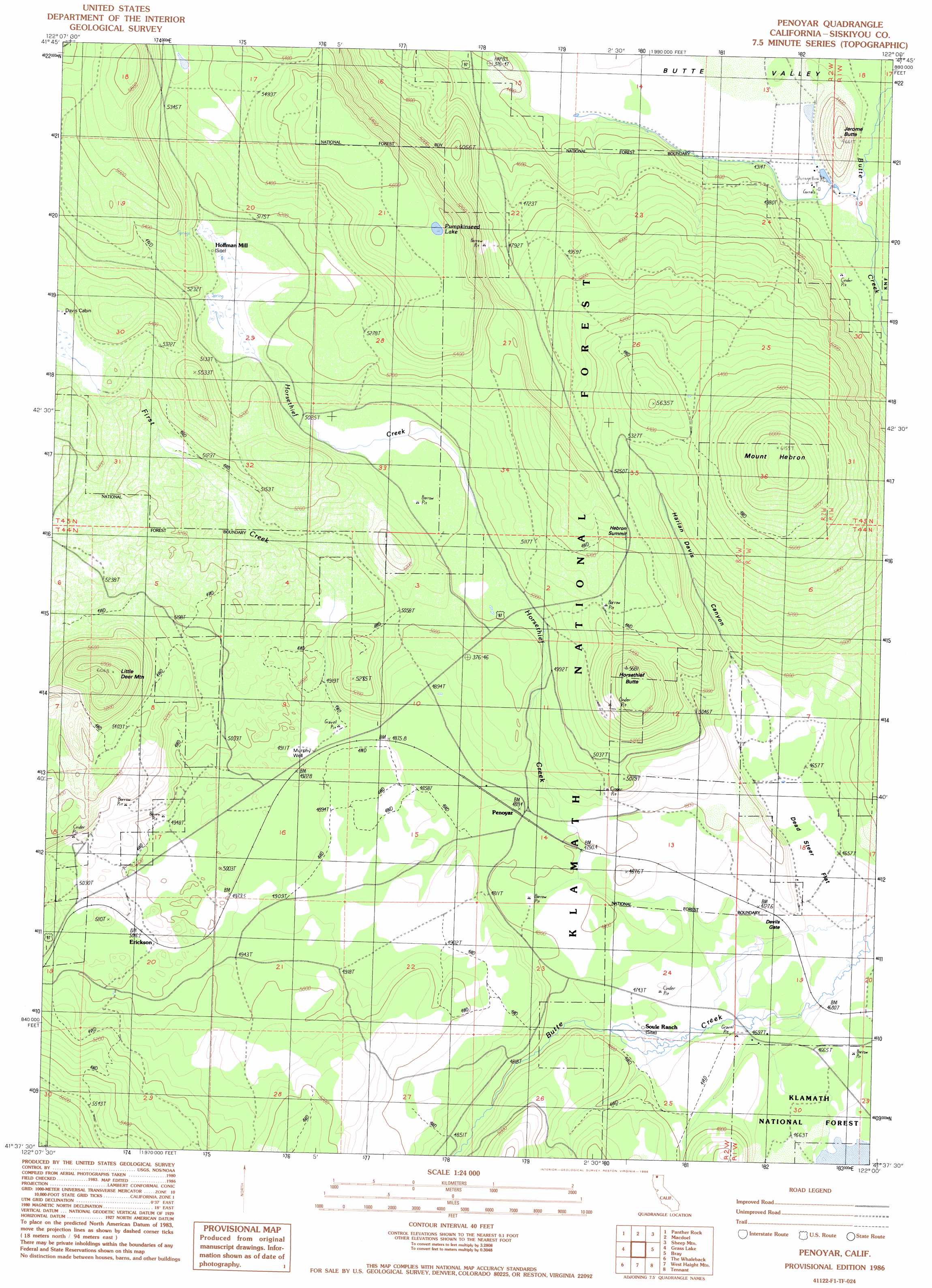
Penoyar Topo Map California
To zoom in, hover over the map of Penoyar
USGS Topo Quad 41122f1 - 1:24,000 scale
| Topo Map Name: | Penoyar |
| USGS Topo Quad ID: | 41122f1 |
| Print Size: | ca. 21 1/4" wide x 27" high |
| Southeast Coordinates: | 41.625° N latitude / 122° W longitude |
| Map Center Coordinates: | 41.6875° N latitude / 122.0625° W longitude |
| U.S. State: | CA |
| Filename: | o41122f1.jpg |
| Download Map JPG Image: | Penoyar topo map 1:24,000 scale |
| Map Type: | Topographic |
| Topo Series: | 7.5´ |
| Map Scale: | 1:24,000 |
| Source of Map Images: | United States Geological Survey (USGS) |
| Alternate Map Versions: |
Penoyar CA 1986, updated 1986 Download PDF Buy paper map Penoyar CA 2001, updated 2004 Download PDF Buy paper map Penoyar CA 2012 Download PDF Buy paper map Penoyar CA 2015 Download PDF Buy paper map |
| FStopo: | US Forest Service topo Penoyar is available: Download FStopo PDF Download FStopo TIF |
1:24,000 Topo Quads surrounding Penoyar
Copco |
Secret Spring Mountain |
Sams Neck |
Dorris |
Sheepy Lake |
Dewey Gulch |
Panther Rock |
Macdoel |
Sheep Mountain |
Red Rock Lakes |
Solomons Temple |
Grass Lake |
Penoyar |
Bray |
Sharp Mountain |
Juniper Flat |
The Whaleback |
West Haight Mountain |
Tennant |
Garner Mountain |
Hotlum |
Mount Shasta |
Ash Creek Butte |
Rainbow Mountain |
Horse Peak |
> Back to 41122e1 at 1:100,000 scale
> Back to 41122a1 at 1:250,000 scale
> Back to U.S. Topo Maps home
Penoyar topo map: Gazetteer
Penoyar: Flats
Dead Steer Flat elevation 1416m 4645′Penoyar: Gaps
Devils Gate elevation 1438m 4717′Hebron Summit elevation 1588m 5209′
Penoyar: Lakes
Pumpkinseed Lake elevation 1692m 5551′Penoyar: Populated Places
Erickson elevation 1532m 5026′Jerome elevation 1319m 4327′
Leaf elevation 1417m 4648′
Penoyar elevation 1481m 4858′
Penoyar: Streams
First Creek elevation 1510m 4954′Penoyar: Summits
Horsethief Butte elevation 1719m 5639′Jerome Butte elevation 1418m 4652′
Little Deer Mountain elevation 1784m 5853′
Mount Hebron elevation 1872m 6141′
Penoyar: Valleys
Harlan Davis Canyon elevation 1431m 4694′Penoyar: Wells
Murphy Well elevation 1513m 4963′Penoyar digital topo map on disk
Buy this Penoyar topo map showing relief, roads, GPS coordinates and other geographical features, as a high-resolution digital map file on DVD: