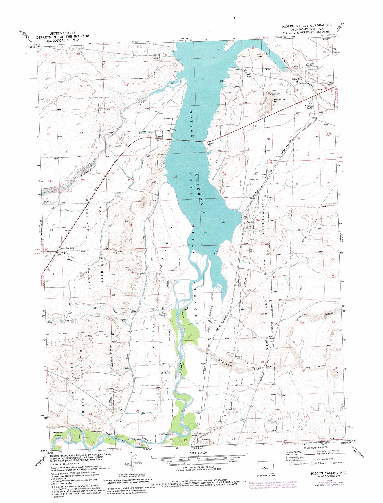
Hidden Valley Topo Map Wyoming
To zoom in, hover over the map of Hidden Valley
USGS Topo Quad 43108b2 - 1:24,000 scale
| Topo Map Name: | Hidden Valley |
| USGS Topo Quad ID: | 43108b2 |
| Print Size: | ca. 21 1/4" wide x 27" high |
| Southeast Coordinates: | 43.125° N latitude / 108.125° W longitude |
| Map Center Coordinates: | 43.1875° N latitude / 108.1875° W longitude |
| U.S. State: | WY |
| Filename: | o43108b2.jpg |
| Download Map JPG Image: | Hidden Valley topo map 1:24,000 scale |
| Map Type: | Topographic |
| Topo Series: | 7.5´ |
| Map Scale: | 1:24,000 |
| Source of Map Images: | United States Geological Survey (USGS) |
| Alternate Map Versions: |
Hidden Valley WY 1951, updated 1953 Download PDF Buy paper map Hidden Valley WY 1957, updated 1958 Download PDF Buy paper map Hidden Valley WY 1957, updated 1981 Download PDF Buy paper map Hidden Valley WY 2012 Download PDF Buy paper map Hidden Valley WY 2015 Download PDF Buy paper map |
1:24,000 Topo Quads surrounding Hidden Valley
Mexican Pass |
Morrison Canyon |
Boysen |
Birdseye Pass |
Guffy Peak |
Mexican Pass Sw |
Mexican Pass Se |
Bonneville Sw |
Bonneville |
Picard Ranch |
Lost Wells Butte |
Riverton Ne |
Hidden Valley |
Shoshoni |
Ocla Draw |
Riverton West |
Riverton East |
Indian Butte |
Fuller Reservoir |
Haybarn Hill |
Arapahoe |
Arapahoe Ne |
Alkali Butte |
Campbell Ridge |
Double Butte |
> Back to 43108a1 at 1:100,000 scale
> Back to 43108a1 at 1:250,000 scale
> Back to U.S. Topo Maps home
Hidden Valley topo map: Gazetteer
Hidden Valley: Canals
Le Clair Drain elevation 1461m 4793′Pavillion Main Lateral elevation 1464m 4803′
Springs Drain elevation 1465m 4806′
Hidden Valley: Streams
Dry Cheyenne Creek elevation 1462m 4796′Fivemile Creek elevation 1441m 4727′
Muskrat Creek elevation 1441m 4727′
Poison Creek elevation 1441m 4727′
Hidden Valley: Summits
Water Tank Hill elevation 1542m 5059′Hidden Valley: Valleys
Horsethief Gulch elevation 1452m 4763′Riverton Valley elevation 1458m 4783′
Hidden Valley digital topo map on disk
Buy this Hidden Valley topo map showing relief, roads, GPS coordinates and other geographical features, as a high-resolution digital map file on DVD: