Grawn Topo Map Michigan
To zoom in, hover over the map of Grawn
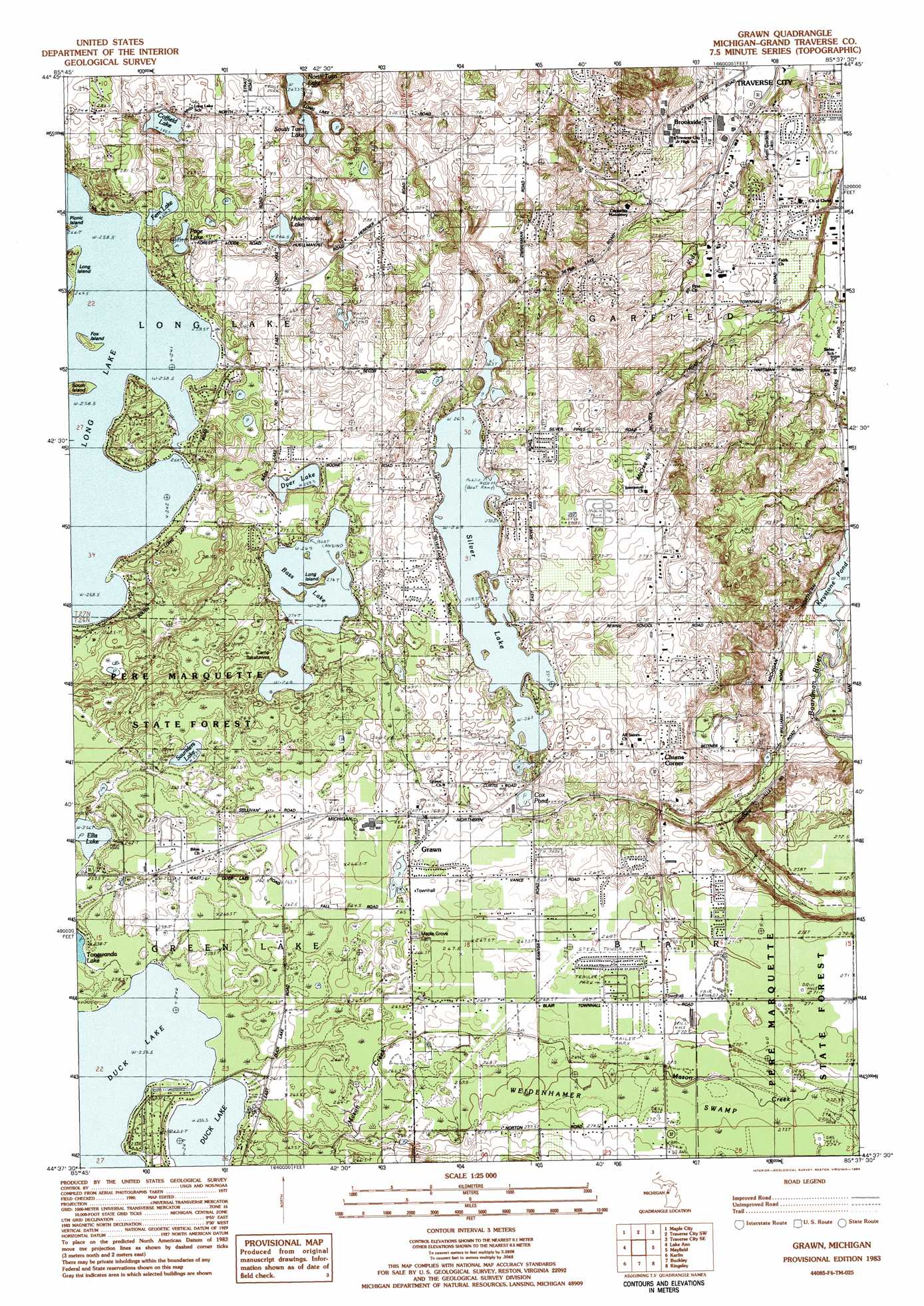
USGS Topo Quad 44085f6 - 1:25,000 scale
| Topo Map Name: | Grawn |
| USGS Topo Quad ID: | 44085f6 |
| Print Size: | ca. 21 1/4" wide x 27" high |
| Southeast Coordinates: | 44.625° N latitude / 85.625° W longitude |
| Map Center Coordinates: | 44.6875° N latitude / 85.6875° W longitude |
| U.S. State: | MI |
| Filename: | l44085f6.jpg |
| Download Map JPG Image: | Grawn topo map 1:25,000 scale |
| Map Type: | Topographic |
| Topo Series: | 7.5´ |
| Map Scale: | 1:25,000 |
| Source of Map Images: | United States Geological Survey (USGS) |
| Alternate Map Versions: |
Grawn MI 1983, updated 1984 Download PDF Buy paper map |
1:24,000 Topo Quads surrounding Grawn
Glen Arbor |
Good Harbor Bay |
Suttons Bay |
Mapleton |
Elk Rapids |
Burdickville |
Maple City |
Traverse City Sw |
Traverse City Se |
Williamsburg |
Platte River |
Lake Ann |
Grawn |
Mayfield |
Jacks Landing |
Thompsonville |
Karlin |
Buckley |
Kingsley |
Walton |
Copemish |
Harlan |
Mesick |
Mesick Ne |
Manton |
> Back to 44085e1 at 1:100,000 scale
> Back to 44084a1 at 1:250,000 scale
> Back to U.S. Topo Maps home
Grawn topo map: Gazetteer
Grawn: Islands
Fox Island elevation 262m 859′Long Island elevation 271m 889′
Long Island elevation 261m 856′
Picnic Island elevation 260m 853′
South Island elevation 268m 879′
Grawn: Lakes
Bass Lake elevation 269m 882′Coffield Lake elevation 260m 853′
Cox Pond elevation 264m 866′
Duck Lake elevation 256m 839′
Dyer Lake elevation 269m 882′
Ellis Lake elevation 256m 839′
Fern Lake elevation 258m 846′
Huellmantel Lake elevation 266m 872′
Keystone Pond elevation 199m 652′
Long Lake elevation 258m 846′
North Twin Lake elevation 268m 879′
Page Lake elevation 267m 875′
Saunders Lake elevation 257m 843′
Silver Lake elevation 263m 862′
South Twin Lake elevation 269m 882′
Yonkers Lake elevation 260m 853′
Grawn: Parks
Blair Park elevation 270m 885′East Silver Lake Park elevation 278m 912′
Montague Island Park elevation 266m 872′
Veterans Memorial Roadside Park elevation 257m 843′
Warren Field elevation 215m 705′
Wuerfel Park elevation 272m 892′
Grawn: Populated Places
Brookside elevation 199m 652′Chums Corner elevation 271m 889′
Grawn elevation 267m 875′
Meadow Lane Mobile Home Park elevation 280m 918′
Silver Lake View Mobile Home Park elevation 272m 892′
Silver Shores Mobile Home Park elevation 269m 882′
Suburban Estates Mobile Home Park elevation 292m 958′
Grawn: Post Offices
Beitner Post Office (historical) elevation 227m 744′Grawn Post Office elevation 268m 879′
Keystone Post Office (historical) elevation 209m 685′
Grawn: Streams
Mason Creek elevation 256m 839′Grawn: Summits
McCrea Hill elevation 285m 935′Grawn digital topo map on disk
Buy this Grawn topo map showing relief, roads, GPS coordinates and other geographical features, as a high-resolution digital map file on DVD: