Brethern Topo Map Michigan
To zoom in, hover over the map of Brethern
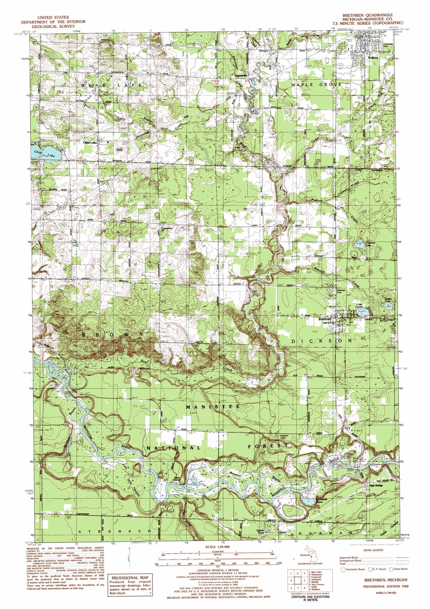
USGS Topo Quad 44086c1 - 1:25,000 scale
| Topo Map Name: | Brethern |
| USGS Topo Quad ID: | 44086c1 |
| Print Size: | ca. 21 1/4" wide x 27" high |
| Southeast Coordinates: | 44.25° N latitude / 86° W longitude |
| Map Center Coordinates: | 44.3125° N latitude / 86.0625° W longitude |
| U.S. State: | MI |
| Filename: | l44086c1.jpg |
| Download Map JPG Image: | Brethern topo map 1:25,000 scale |
| Map Type: | Topographic |
| Topo Series: | 7.5´ |
| Map Scale: | 1:25,000 |
| Source of Map Images: | United States Geological Survey (USGS) |
| Alternate Map Versions: |
Brethren MI 1982, updated 1983 Download PDF Buy paper map |
| FStopo: | US Forest Service topo Brethren is available: Download FStopo PDF Download FStopo TIF |
1:24,000 Topo Quads surrounding Brethern
Elberta |
Benzonia |
Thompsonville |
Karlin |
|
Bear Lake |
Pleasanton |
Copemish |
Harlan |
|
Parkdale |
Onekama |
Brethern |
Marilla |
Yuma |
Manistee Ne |
Freesoil Nw |
Freesoil Ne |
Peacock Nw |
Peacock Ne |
Kings Corners |
Freesoil Sw |
Freesoil Se |
Peacock Sw |
Peacock Se |
> Back to 44086a1 at 1:100,000 scale
> Back to 44086a1 at 1:250,000 scale
> Back to U.S. Topo Maps home
Brethern topo map: Gazetteer
Brethern: Bridges
Christy Bridge elevation 207m 679′High Bridge elevation 210m 688′
Potter Bridge elevation 208m 682′
Brethern: Guts
Browns Bayou elevation 186m 610′Deer Lake Bayou elevation 185m 606′
Sergant Bayou elevation 182m 597′
Brethern: Lakes
Blacksmith Bayou elevation 186m 610′Center Lake elevation 218m 715′
Chief Lake elevation 229m 751′
Clarence Lake elevation 218m 715′
Lake Elinor elevation 218m 715′
Sylvan Pond elevation 207m 679′
Brethern: Parks
Battle House Historical Marker elevation 228m 748′Dickson Township Park elevation 221m 725′
Kaleva Historical Marker elevation 228m 748′
Kaleva Roadside Park elevation 228m 748′
Manikawa Park elevation 221m 725′
Brethern: Populated Places
Brethren elevation 220m 721′Chief Lake elevation 234m 767′
Kaleva elevation 228m 748′
Brethern: Post Offices
Brethren Post Office elevation 220m 721′High Bridge Post Office (historical) elevation 210m 688′
Kaleva Post Office elevation 228m 748′
Tanner Post Office (historical) elevation 214m 702′
Brethern: Streams
Bear Creek elevation 183m 600′Beaver Creek elevation 212m 695′
Boswell Creek elevation 194m 636′
Cedar Creek elevation 203m 666′
Chicken Creek elevation 216m 708′
Horseshoe Creek elevation 212m 695′
Little Beaver Creek elevation 209m 685′
Pine Creek elevation 186m 610′
Podunk Creek elevation 199m 652′
Sylvan Creek elevation 207m 679′
Williamson Creek elevation 207m 679′
Brethern: Swamps
Cedar Swamp elevation 213m 698′Brethern digital topo map on disk
Buy this Brethern topo map showing relief, roads, GPS coordinates and other geographical features, as a high-resolution digital map file on DVD: