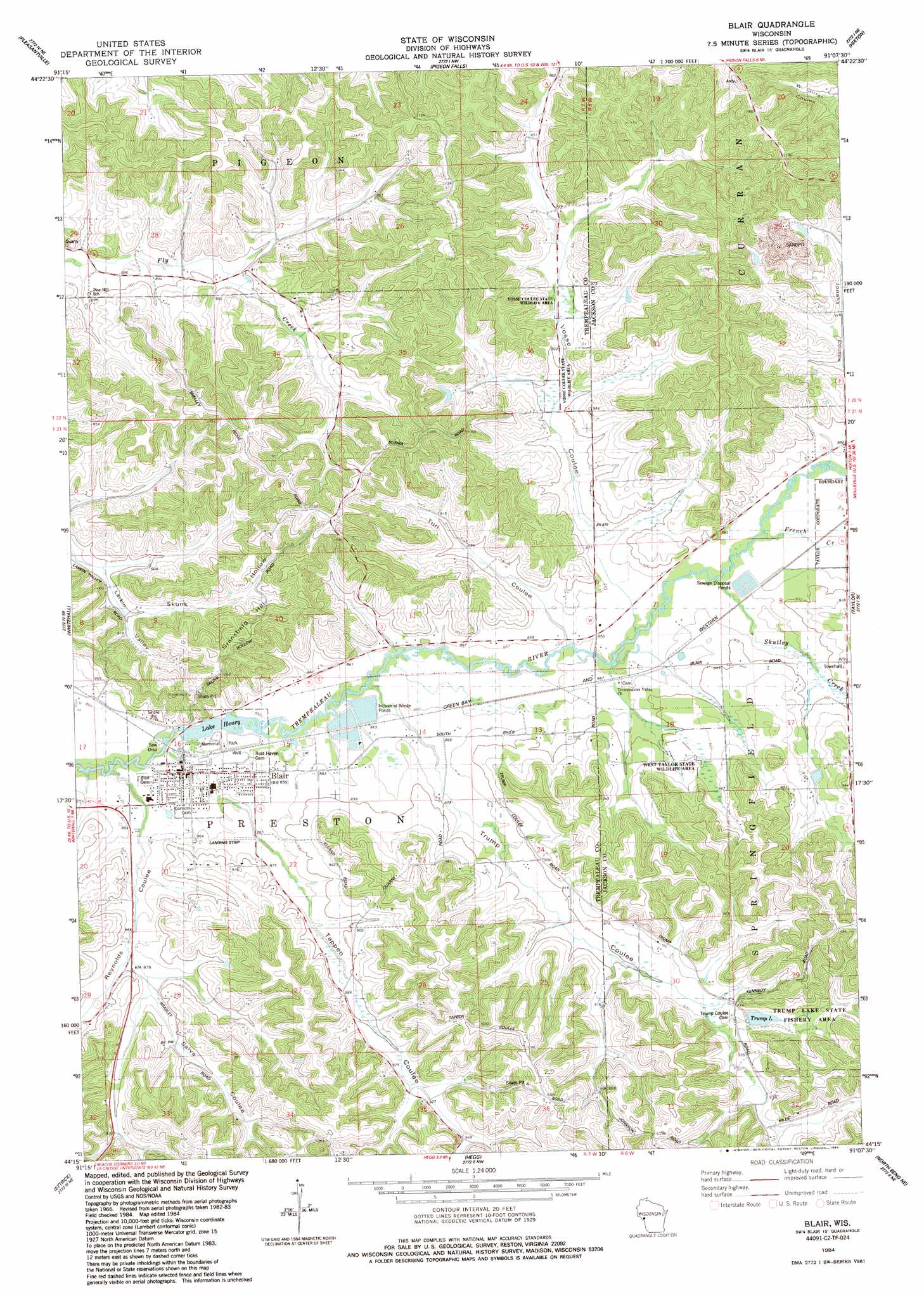
Blair Topo Map Wisconsin
To zoom in, hover over the map of Blair
USGS Topo Quad 44091c2 - 1:24,000 scale
| Topo Map Name: | Blair |
| USGS Topo Quad ID: | 44091c2 |
| Print Size: | ca. 21 1/4" wide x 27" high |
| Southeast Coordinates: | 44.25° N latitude / 91.125° W longitude |
| Map Center Coordinates: | 44.3125° N latitude / 91.1875° W longitude |
| U.S. State: | WI |
| Filename: | o44091c2.jpg |
| Download Map JPG Image: | Blair topo map 1:24,000 scale |
| Map Type: | Topographic |
| Topo Series: | 7.5´ |
| Map Scale: | 1:24,000 |
| Source of Map Images: | United States Geological Survey (USGS) |
| Alternate Map Versions: |
Blair WI 1984, updated 1984 Download PDF Buy paper map Blair WI 2010 Download PDF Buy paper map Blair WI 2013 Download PDF Buy paper map Blair WI 2015 Download PDF Buy paper map |
1:24,000 Topo Quads surrounding Blair
Strum |
Strum Se |
Osseo |
Price |
Fairchild |
Elk Creek |
Pleasantville |
Pigeon Falls |
Hixton |
Alma Center |
Independence |
Whitehall |
Blair |
Taylor |
Stenulson Coulee |
Tamarack |
Ettrick |
Hegg |
North Bend Ne |
Melrose |
Trempealeau |
Galesville |
Stevenstown |
North Bend |
Four Corners |
> Back to 44091a1 at 1:100,000 scale
> Back to 44090a1 at 1:250,000 scale
> Back to U.S. Topo Maps home
Blair topo map: Gazetteer
Blair: Airports
Blair Airport elevation 267m 875′Blair: Dams
Blair Mill Dam elevation 260m 853′Chier Sand Company 3WC78804 Dam elevation 342m 1122′
Trump Lake G12.224 Dam elevation 281m 921′
Blair: Parks
Memorial Park elevation 259m 849′Trump Lake State Fishery Area elevation 286m 938′
Vosse Coulee State Wildlife Area elevation 284m 931′
West Taylor State Wildlife Area elevation 280m 918′
Blair: Populated Places
Blair elevation 260m 853′Blair: Reservoirs
1 Reservoir elevation 342m 1122′Lake Henry elevation 257m 843′
Lake Henry 173 elevation 260m 853′
Trump Lake elevation 284m 931′
Trump Lake 1 elevation 281m 921′
Blair: Streams
French Creek elevation 267m 875′Reynolds Coulee Creek elevation 256m 839′
Skutley Creek elevation 266m 872′
Tappen Coulee Creek elevation 256m 839′
Trump Coulee Creek elevation 259m 849′
Vosse Coulee Creek elevation 262m 859′
Blair: Summits
Gransberg Hill elevation 329m 1079′Blair: Valleys
Reynolds Coulee elevation 262m 859′Salva Coulee elevation 266m 872′
Skunk Hollow elevation 277m 908′
Tappen Coulee elevation 264m 866′
Trump Coulee elevation 269m 882′
Turi Coulee elevation 262m 859′
Vosse Coulee elevation 266m 872′
Blair digital topo map on disk
Buy this Blair topo map showing relief, roads, GPS coordinates and other geographical features, as a high-resolution digital map file on DVD: