Rainbow Peak Topo Map Idaho
To zoom in, hover over the map of Rainbow Peak
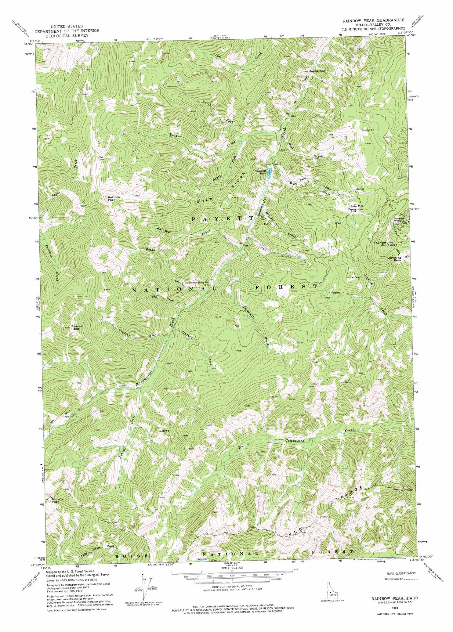
USGS Topo Quad 44115h2 - 1:24,000 scale
| Topo Map Name: | Rainbow Peak |
| USGS Topo Quad ID: | 44115h2 |
| Print Size: | ca. 21 1/4" wide x 27" high |
| Southeast Coordinates: | 44.875° N latitude / 115.125° W longitude |
| Map Center Coordinates: | 44.9375° N latitude / 115.1875° W longitude |
| U.S. State: | ID |
| Filename: | o44115h2.jpg |
| Download Map JPG Image: | Rainbow Peak topo map 1:24,000 scale |
| Map Type: | Topographic |
| Topo Series: | 7.5´ |
| Map Scale: | 1:24,000 |
| Source of Map Images: | United States Geological Survey (USGS) |
| Alternate Map Versions: |
Rainbow Peak ID 1973, updated 1975 Download PDF Buy paper map Rainbow Peak ID 2004, updated 2007 Download PDF Buy paper map Rainbow Peak ID 2011 Download PDF Buy paper map Rainbow Peak ID 2013 Download PDF Buy paper map |
| FStopo: | US Forest Service topo Rainbow Peak is available: Download FStopo PDF Download FStopo TIF |
1:24,000 Topo Quads surrounding Rainbow Peak
Wolf Fang Peak |
Big Creek |
Bismark Mountain |
Acorn Butte |
Vinegar Hill |
Profile Gap |
Edwardsburg |
Center Mountain |
Monument |
Mormon Mountain |
Yellow Pine |
Stibnite |
Rainbow Peak |
Safety Creek |
Shellrock Peak |
Chilcoot Peak |
Big Chief Creek |
Big Baldy |
Pungo Mountain |
Norton Ridge |
Pistol Lake |
Chinook Mountain |
Artillery Dome |
Little Soldier Mountain |
Sliderock Ridge |
> Back to 44115e1 at 1:100,000 scale
> Back to 44114a1 at 1:250,000 scale
> Back to U.S. Topo Maps home
Rainbow Peak topo map: Gazetteer
Rainbow Peak: Cliffs
Cox Point elevation 2592m 8503′Rainbow Peak: Lakes
Roosevelt Lake elevation 1851m 6072′Rainbow Peak: Mines
Dewey Mine elevation 2286m 7500′Sunnyside Mine elevation 2477m 8126′
Rainbow Peak: Pillars
Suicide Rock elevation 1926m 6318′Rainbow Peak: Ridges
Gold Ridge elevation 2250m 7381′Rainbow Peak: Streams
Annie Creek elevation 1973m 6473′Botha Creek elevation 1907m 6256′
Boulder Creek elevation 1936m 6351′
Century Creek elevation 1927m 6322′
Coon Creek elevation 1875m 6151′
Divide Creek elevation 1862m 6108′
Fall Creek elevation 1829m 6000′
Mule Creek elevation 1842m 6043′
Neff Creek elevation 1917m 6289′
North Fork Trap Creek elevation 1870m 6135′
Rainbow Creek elevation 1883m 6177′
South Fork Trap Creek elevation 1872m 6141′
Threemile Creek elevation 1893m 6210′
Trap Creek elevation 1830m 6003′
Rainbow Peak: Summits
Dewey Hill elevation 2389m 7837′Lightning Peak elevation 2592m 8503′
Murphy Peak elevation 2811m 9222′
Pyramid Point elevation 2737m 8979′
Rainbow Peak elevation 2829m 9281′
Thunder Mountain elevation 2612m 8569′
Rainbow Peak digital topo map on disk
Buy this Rainbow Peak topo map showing relief, roads, GPS coordinates and other geographical features, as a high-resolution digital map file on DVD: