White Lake Topo Map Wisconsin
To zoom in, hover over the map of White Lake
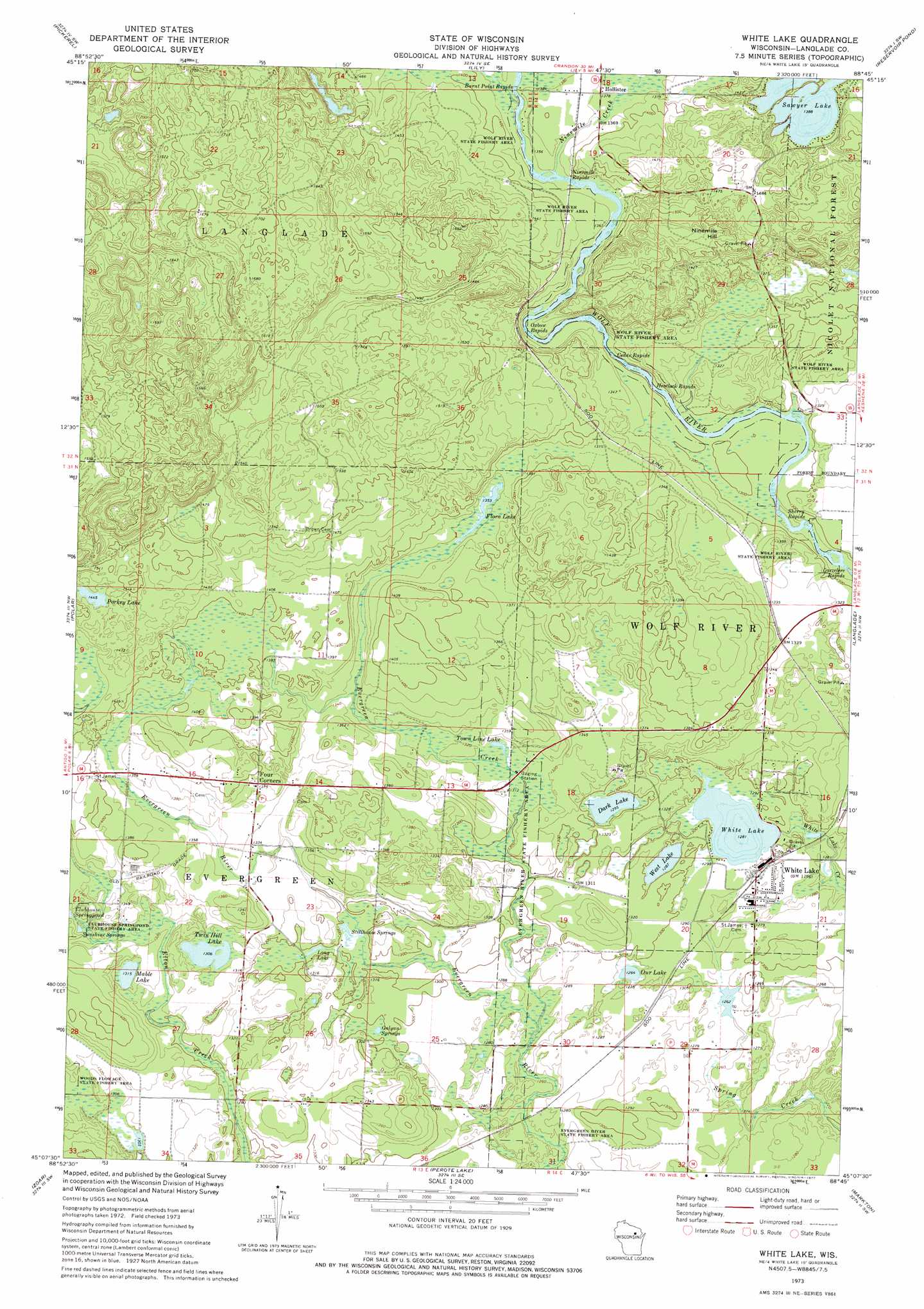
USGS Topo Quad 45088b7 - 1:24,000 scale
| Topo Map Name: | White Lake |
| USGS Topo Quad ID: | 45088b7 |
| Print Size: | ca. 21 1/4" wide x 27" high |
| Southeast Coordinates: | 45.125° N latitude / 88.75° W longitude |
| Map Center Coordinates: | 45.1875° N latitude / 88.8125° W longitude |
| U.S. State: | WI |
| Filename: | o45088b7.jpg |
| Download Map JPG Image: | White Lake topo map 1:24,000 scale |
| Map Type: | Topographic |
| Topo Series: | 7.5´ |
| Map Scale: | 1:24,000 |
| Source of Map Images: | United States Geological Survey (USGS) |
| Alternate Map Versions: |
White Lake WI 1973, updated 1977 Download PDF Buy paper map White Lake WI 2011 Download PDF Buy paper map White Lake WI 2013 Download PDF Buy paper map White Lake WI 2015 Download PDF Buy paper map |
| FStopo: | US Forest Service topo White Lake is available: Download FStopo PDF Download FStopo TIF |
1:24,000 Topo Quads surrounding White Lake
Post Lake |
Mole Lake |
Roberts Lake |
Wabeno |
Otter Lake |
Pearson |
Pickerel |
Lily |
Reservoir Pond |
Townsend |
Bryant |
Polar |
White Lake |
Langlade |
Shadow Lake |
Mattoon |
Zoar |
Perote Lake |
Markton |
Fredenberg Lake |
Regina |
Burney Lake |
Neopit |
Keshena |
Legend Lake |
> Back to 45088a1 at 1:100,000 scale
> Back to 45088a1 at 1:250,000 scale
> Back to U.S. Topo Maps home
White Lake topo map: Gazetteer
White Lake: Lakes
Dark Lake elevation 395m 1295′Flora Lake elevation 413m 1354′
Galyan Springs elevation 396m 1299′
Long Lake elevation 396m 1299′
Mable Lake elevation 401m 1315′
Our Lake elevation 390m 1279′
Porkey Lake elevation 440m 1443′
Sawyer Lake elevation 423m 1387′
Stillhouse Springs elevation 395m 1295′
Town Line Lake elevation 401m 1315′
Twin Hill Lake elevation 398m 1305′
West Lake elevation 392m 1286′
White Lake elevation 390m 1279′
White Lake: Parks
Bear Caves State Natural Area elevation 425m 1394′Evergreen River State Fishery Area elevation 389m 1276′
Flora Spring Pond State Natural Area elevation 412m 1351′
Oxbow Rapids Upper Wolf River State Natural Area elevation 422m 1384′
White Lake: Populated Places
Four Corners elevation 419m 1374′Hollister elevation 421m 1381′
White Lake elevation 391m 1282′
White Lake: Rapids
Burnt Point Rapids elevation 418m 1371′Cedar Rapids elevation 402m 1318′
Hemlock Rapids elevation 395m 1295′
Larzelere Rapids elevation 384m 1259′
Ninemile Rapids elevation 414m 1358′
Oxbow Rapids elevation 408m 1338′
Sherry Rapids elevation 390m 1279′
White Lake: Springs
Sunshine Springs elevation 402m 1318′White Lake: Streams
Evergreen Creek elevation 384m 1259′Ninemile Creek elevation 413m 1354′
White Lake: Summits
Ninemile Hill elevation 463m 1519′White Lake digital topo map on disk
Buy this White Lake topo map showing relief, roads, GPS coordinates and other geographical features, as a high-resolution digital map file on DVD: