Dewey Topo Map Montana
To zoom in, hover over the map of Dewey
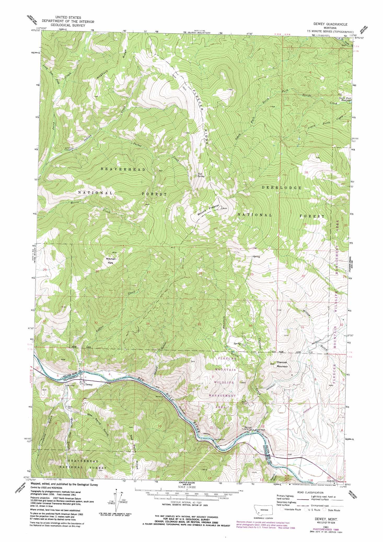
USGS Topo Quad 45112g7 - 1:24,000 scale
| Topo Map Name: | Dewey |
| USGS Topo Quad ID: | 45112g7 |
| Print Size: | ca. 21 1/4" wide x 27" high |
| Southeast Coordinates: | 45.75° N latitude / 112.75° W longitude |
| Map Center Coordinates: | 45.8125° N latitude / 112.8125° W longitude |
| U.S. State: | MT |
| Filename: | o45112g7.jpg |
| Download Map JPG Image: | Dewey topo map 1:24,000 scale |
| Map Type: | Topographic |
| Topo Series: | 7.5´ |
| Map Scale: | 1:24,000 |
| Source of Map Images: | United States Geological Survey (USGS) |
| Alternate Map Versions: |
Dewey MT 1961, updated 1964 Download PDF Buy paper map Dewey MT 1961, updated 1974 Download PDF Buy paper map Dewey MT 1961, updated 1989 Download PDF Buy paper map Dewey MT 1997, updated 2002 Download PDF Buy paper map Dewey MT 2011 Download PDF Buy paper map Dewey MT 2014 Download PDF Buy paper map |
| FStopo: | US Forest Service topo Dewey is available: Download FStopo PDF Download FStopo TIF |
1:24,000 Topo Quads surrounding Dewey
Mount Haggin |
Anaconda South |
Opportunity |
Ramsay |
Butte North |
Lincoln Gulch |
Dickie Peak |
Burnt Mountain |
Buxton |
Butte South |
Dickie Hills |
Wise River |
Dewey |
Tucker Creek |
Mount Humbug |
Stine Mountain |
Vipond Park |
Cattle Gulch |
Melrose |
Wickiup Creek |
Maurice Mountain |
Mount Tahepia |
Storm Peak |
Earls Gulch |
Nez Perce Hollow |
> Back to 45112e1 at 1:100,000 scale
> Back to 45112a1 at 1:250,000 scale
> Back to U.S. Topo Maps home
Dewey topo map: Gazetteer
Dewey: Dams
Big Hole Dam elevation 1659m 5442′Dewey: Flats
Mitchell Park elevation 2511m 8238′Dewey: Mines
Big Hole Copper Mine elevation 1879m 6164′Cayuga Mine elevation 1910m 6266′
Grafton Mine elevation 2551m 8369′
NE NW Section 22 Mine elevation 2409m 7903′
NW NW Section 9 Mine elevation 1829m 6000′
NW SE Section 15 Mine elevation 2276m 7467′
NW SW Section 9 Mine elevation 1868m 6128′
Old Tom Horn Mine elevation 2412m 7913′
Dewey: Populated Places
Dewey elevation 1679m 5508′Dewey: Post Offices
Dewey Post Office (historical) elevation 1679m 5508′Dewey: Ridges
Fleecer Ridge elevation 2344m 7690′Hogback Ridge elevation 2279m 7477′
Dewey: Springs
Tub Spring elevation 2521m 8270′Dewey: Streams
Charcoal Creek elevation 1653m 5423′Indian Creek elevation 1837m 6026′
Leffler Creek elevation 1678m 5505′
Long Tom Creek elevation 1924m 6312′
Parker Creek elevation 1952m 6404′
Dewey: Summits
Charcoal Mountain elevation 2028m 6653′Mount Fleecer elevation 2873m 9425′
Dewey: Valleys
Charcoal Gulch elevation 1867m 6125′Limekiln Gulch elevation 1698m 5570′
Nez Perce Gulch elevation 1683m 5521′
Quartz Hill Gulch elevation 1701m 5580′
Sawmill Gulch elevation 1646m 5400′
Sheep Gulch elevation 1694m 5557′
Dewey digital topo map on disk
Buy this Dewey topo map showing relief, roads, GPS coordinates and other geographical features, as a high-resolution digital map file on DVD: