Butte South Topo Map Montana
To zoom in, hover over the map of Butte South
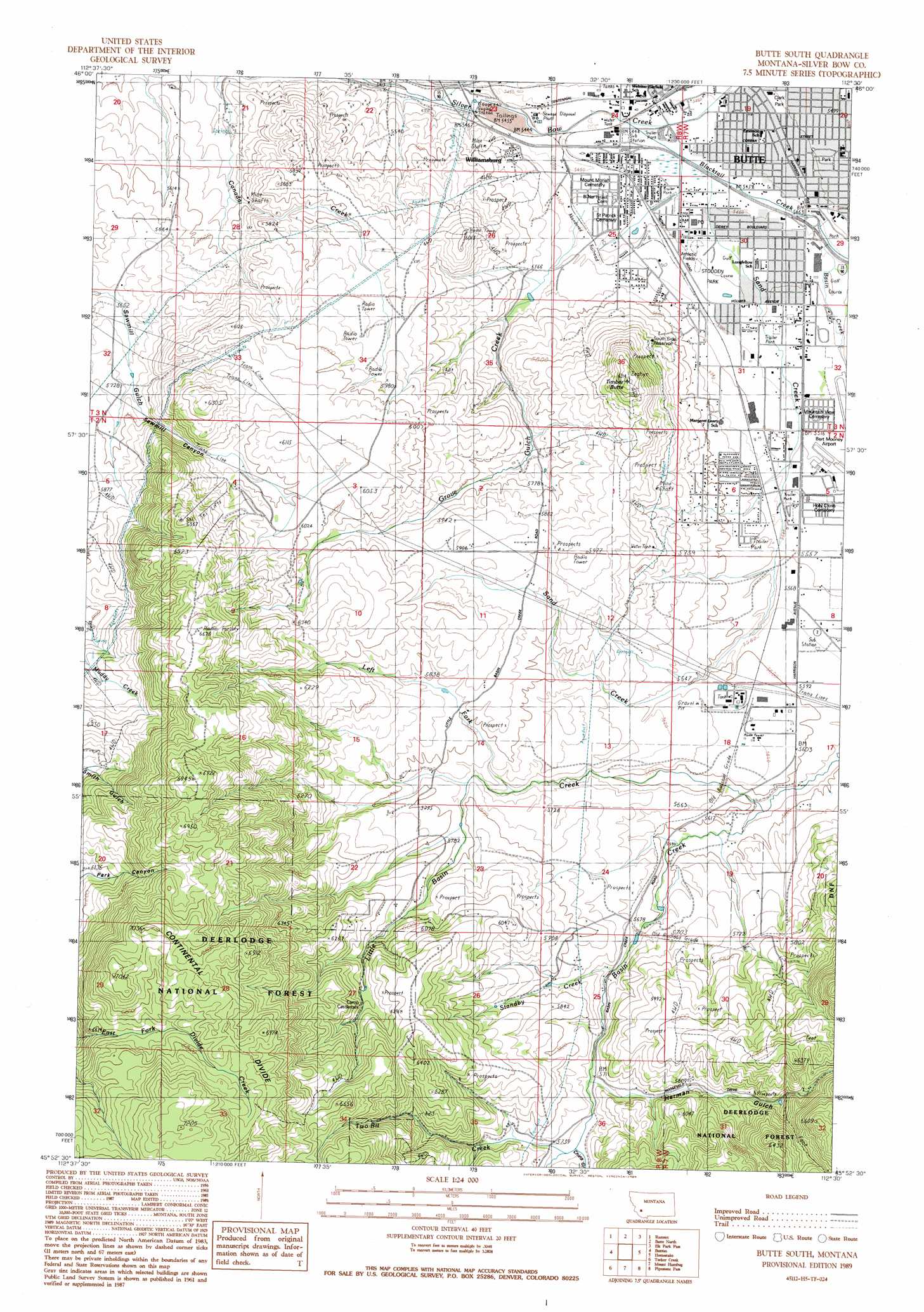
USGS Topo Quad 45112h5 - 1:24,000 scale
| Topo Map Name: | Butte South |
| USGS Topo Quad ID: | 45112h5 |
| Print Size: | ca. 21 1/4" wide x 27" high |
| Southeast Coordinates: | 45.875° N latitude / 112.5° W longitude |
| Map Center Coordinates: | 45.9375° N latitude / 112.5625° W longitude |
| U.S. State: | MT |
| Filename: | o45112h5.jpg |
| Download Map JPG Image: | Butte South topo map 1:24,000 scale |
| Map Type: | Topographic |
| Topo Series: | 7.5´ |
| Map Scale: | 1:24,000 |
| Source of Map Images: | United States Geological Survey (USGS) |
| Alternate Map Versions: |
Butte South MT 1989, updated 1989 Download PDF Buy paper map Butte South MT 1989, updated 1989 Download PDF Buy paper map Butte South MT 1996, updated 1998 Download PDF Buy paper map Butte South MT 2011 Download PDF Buy paper map Butte South MT 2014 Download PDF Buy paper map |
| FStopo: | US Forest Service topo Butte South is available: Download FStopo PDF Download FStopo TIF |
1:24,000 Topo Quads surrounding Butte South
Warm Springs |
Orofino Mountain |
Lockhart Meadows |
Sheepshead Mountain |
Bison Canyon |
Opportunity |
Ramsay |
Butte North |
Elk Park Pass |
Whitetail Peak |
Burnt Mountain |
Buxton |
Butte South |
Homestake |
Delmoe Lake |
Dewey |
Tucker Creek |
Mount Humbug |
Pipestone Pass |
Grace |
Cattle Gulch |
Melrose |
Wickiup Creek |
Table Mountain |
Silver Star |
> Back to 45112e1 at 1:100,000 scale
> Back to 45112a1 at 1:250,000 scale
> Back to U.S. Topo Maps home
Butte South topo map: Gazetteer
Butte South: Airports
Flying Arrow Ranch Airport elevation 1745m 5725′Smith Field elevation 1829m 6000′
Butte South: Crossings
Interchange 126 elevation 1663m 5456′Interchange 127 elevation 1665m 5462′
Butte South: Dams
Grove Gulch Dam elevation 1748m 5734′Butte South: Mines
Butte Ardsley Mine elevation 1697m 5567′Canadian Mine elevation 1707m 5600′
Copper City I Mine elevation 1685m 5528′
NE SE Section 4 Mine elevation 1855m 6085′
NE SW Section 22 Mine elevation 1686m 5531′
Silver Queen Mine elevation 1673m 5488′
Butte South: Parks
Clark Park elevation 1671m 5482′Father Sheehan Park elevation 1666m 5465′
Stodden Park elevation 1671m 5482′
Butte South: Populated Places
Newcomb elevation 1708m 5603′Valley Vista Mobile Home Community elevation 1697m 5567′
Williamsburg elevation 1677m 5501′
Butte South: Post Offices
Butte Post Office elevation 1663m 5456′Butte South: Springs
02N07W06BBB_01 Spring elevation 1733m 5685′02N07W06CBD_01 Spring elevation 1729m 5672′
02N07W30ADA_01 Spring elevation 1824m 5984′
03N07W31CCB_01 Spring elevation 1720m 5643′
Butte South: Streams
Basin Creek elevation 1665m 5462′Blacktail Creek elevation 1665m 5462′
Grove Gulch Creek elevation 1665m 5462′
Left Fork Little Basin Creek elevation 1730m 5675′
Little Basin Creek elevation 1695m 5561′
Sand Creek elevation 1663m 5456′
Standby Creek elevation 1720m 5643′
Two-Bit Creek elevation 1740m 5708′
Butte South: Summits
Timber Butte elevation 1922m 6305′Butte South: Valleys
China Gulch elevation 1739m 5705′Grove Gulch elevation 1691m 5547′
Herman Gulch elevation 1745m 5725′
Sawmill Canyon elevation 1756m 5761′
Whiskey Gulch elevation 1658m 5439′
Butte South: Wells
02N07W06AAB_01 Well elevation 1685m 5528′02N07W06AAC_02 Well elevation 1690m 5544′
02N07W06ADC_01 Well elevation 1689m 5541′
02N07W06BDD_01 Well elevation 1704m 5590′
02N07W06DBA_01 Well elevation 1694m 5557′
02N07W06DBA_02 Well elevation 1693m 5554′
02N07W06DBA_03 Well elevation 1693m 5554′
02N07W08CAB_01 Well elevation 1700m 5577′
02N07W08CAB_02 Well elevation 1699m 5574′
02N07W08CAC_03 Well elevation 1700m 5577′
02N07W17CCB_01 Well elevation 1696m 5564′
03N07W30BCB_01 Well elevation 1668m 5472′
03N07W30CDD_01 Well elevation 1674m 5492′
03N07W31AAA_01 Well elevation 1673m 5488′
03N07W31ABB_02 Well elevation 1673m 5488′
03N07W31ABC_01 Well elevation 1673m 5488′
03N07W31ABD_01 Well elevation 1672m 5485′
03N07W31ABD_02 Well elevation 1672m 5485′
03N07W31BAC_01 Well elevation 1677m 5501′
03N07W31CB__01 Well elevation 1705m 5593′
03N07W31DAC_01 Well elevation 1679m 5508′
03N07W32BBA_01 Well elevation 1672m 5485′
03N07W32BDB_01 Well elevation 1672m 5485′
03N07W32CCA_01 Well elevation 1679m 5508′
03N08W23BDC_01 Well elevation 1661m 5449′
03N08W24CCC_01 Well elevation 1665m 5462′
Butte South digital topo map on disk
Buy this Butte South topo map showing relief, roads, GPS coordinates and other geographical features, as a high-resolution digital map file on DVD: