Dickie Hills Topo Map Montana
To zoom in, hover over the map of Dickie Hills
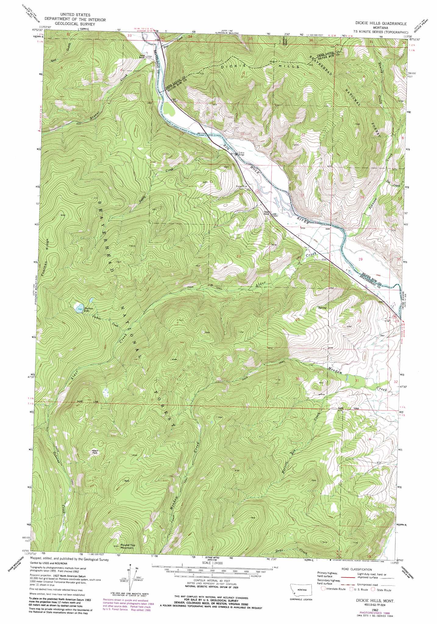
USGS Topo Quad 45113g1 - 1:24,000 scale
| Topo Map Name: | Dickie Hills |
| USGS Topo Quad ID: | 45113g1 |
| Print Size: | ca. 21 1/4" wide x 27" high |
| Southeast Coordinates: | 45.75° N latitude / 113° W longitude |
| Map Center Coordinates: | 45.8125° N latitude / 113.0625° W longitude |
| U.S. State: | MT |
| Filename: | o45113g1.jpg |
| Download Map JPG Image: | Dickie Hills topo map 1:24,000 scale |
| Map Type: | Topographic |
| Topo Series: | 7.5´ |
| Map Scale: | 1:24,000 |
| Source of Map Images: | United States Geological Survey (USGS) |
| Alternate Map Versions: |
Dickie Hills MT 1962, updated 1964 Download PDF Buy paper map Dickie Hills MT 1962, updated 1978 Download PDF Buy paper map Dickie Hills MT 1962, updated 1989 Download PDF Buy paper map Dickie Hills MT 1962, updated 1994 Download PDF Buy paper map Dickie Hills MT 1997, updated 2002 Download PDF Buy paper map Dickie Hills MT 2011 Download PDF Buy paper map Dickie Hills MT 2014 Download PDF Buy paper map |
| FStopo: | US Forest Service topo Dickie Hills is available: Download FStopo PDF Download FStopo TIF |
1:24,000 Topo Quads surrounding Dickie Hills
Storm Lake |
Mount Evans |
Mount Haggin |
Anaconda South |
Opportunity |
Long Peak |
Lower Seymour Lake |
Lincoln Gulch |
Dickie Peak |
Burnt Mountain |
Pine Hill |
Foolhen Mountain |
Dickie Hills |
Wise River |
Dewey |
Proposal Rock |
Shaw Mountain |
Stine Mountain |
Vipond Park |
Cattle Gulch |
Stewart Mountain |
Odell Lake |
Maurice Mountain |
Mount Tahepia |
Storm Peak |
> Back to 45113e1 at 1:100,000 scale
> Back to 45112a1 at 1:250,000 scale
> Back to U.S. Topo Maps home
Dickie Hills topo map: Gazetteer
Dickie Hills: Bridges
Dickie Bridge elevation 1735m 5692′Dickie Hills: Flats
Heart Park elevation 2469m 8100′Dickie Hills: Lakes
Foolhen Lake elevation 2184m 7165′Dickie Hills: Mines
Bryant Creek Mine elevation 2157m 7076′Star Mine elevation 1901m 6236′
Dickie Hills: Ranges
Dickie Hills elevation 2387m 7831′Dickie Hills: Streams
Alder Creek elevation 1732m 5682′Bear Creek elevation 1751m 5744′
Bryant Creek elevation 1751m 5744′
Cat Creek elevation 1814m 5951′
Dowell Creek elevation 1871m 6138′
Foolhen Creek elevation 1984m 6509′
Harriet Lou Creek elevation 1807m 5928′
Henley Creek elevation 1872m 6141′
Johnson Creek elevation 1733m 5685′
Osborne Creek elevation 2125m 6971′
Teddy Creek elevation 1735m 5692′
Dickie Hills: Summits
Round Top Mountain elevation 2846m 9337′Dickie Hills digital topo map on disk
Buy this Dickie Hills topo map showing relief, roads, GPS coordinates and other geographical features, as a high-resolution digital map file on DVD: