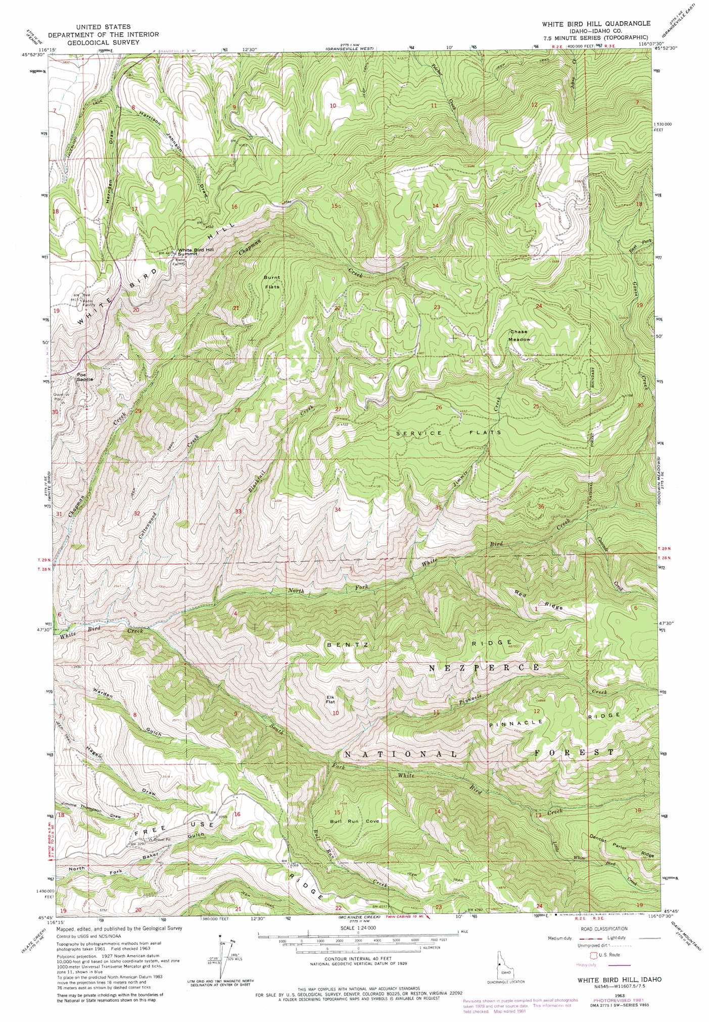
White Bird Hill Topo Map Idaho
To zoom in, hover over the map of White Bird Hill
USGS Topo Quad 45116g2 - 1:24,000 scale
| Topo Map Name: | White Bird Hill |
| USGS Topo Quad ID: | 45116g2 |
| Print Size: | ca. 21 1/4" wide x 27" high |
| Southeast Coordinates: | 45.75° N latitude / 116.125° W longitude |
| Map Center Coordinates: | 45.8125° N latitude / 116.1875° W longitude |
| U.S. State: | ID |
| Filename: | o45116g2.jpg |
| Download Map JPG Image: | White Bird Hill topo map 1:24,000 scale |
| Map Type: | Topographic |
| Topo Series: | 7.5´ |
| Map Scale: | 1:24,000 |
| Source of Map Images: | United States Geological Survey (USGS) |
| Alternate Map Versions: |
White Bird Hill ID 1963, updated 1965 Download PDF Buy paper map White Bird Hill ID 1963, updated 1982 Download PDF Buy paper map White Bird Hill ID 1995, updated 1999 Download PDF Buy paper map White Bird Hill ID 2011 Download PDF Buy paper map White Bird Hill ID 2013 Download PDF Buy paper map |
| FStopo: | US Forest Service topo White Bird Hill is available: Download FStopo PDF Download FStopo TIF |
1:24,000 Topo Quads surrounding White Bird Hill
Keuterville |
Cottonwood |
Nezperce Sw |
Nezperce Se |
Stites |
Moughmer Point |
Fenn |
Grangeville West |
Grangeville East |
Harpster |
Joseph |
White Bird |
White Bird Hill |
Goodwin Meadows |
Hungry Ridge |
Grave Point |
Slate Creek |
Mckinzie Creek |
Dairy Mountain |
Sawyer Ridge |
Kirkwood Creek |
Lucile |
John Day Mountain |
Florence |
Hanover Mountain |
> Back to 45116e1 at 1:100,000 scale
> Back to 45116a1 at 1:250,000 scale
> Back to U.S. Topo Maps home
White Bird Hill topo map: Gazetteer
White Bird Hill: Basins
Bull Run Cove elevation 1052m 3451′White Bird Hill: Flats
Burnt Flats elevation 1351m 4432′Chase Meadow elevation 1589m 5213′
Elk Flat elevation 1175m 3854′
Service Flats elevation 1361m 4465′
White Bird Hill: Gaps
Poe Saddle elevation 1159m 3802′White Bird Hill: Ridges
Bentz Ridge elevation 1311m 4301′Dentist Parlor Ridge elevation 1433m 4701′
Free Use Ridge elevation 1315m 4314′
Pinnacle Ridge elevation 1490m 4888′
Red Ridge elevation 1467m 4812′
White Bird Hill elevation 1405m 4609′
White Bird Hill: Streams
Blacktail Creek elevation 663m 2175′Bull Run Creek elevation 756m 2480′
Cascade Creek elevation 1033m 3389′
Cottonwood Creek elevation 594m 1948′
East Fork Goose Creek elevation 1504m 4934′
Goose Creek elevation 1052m 3451′
Jimmie Creek elevation 833m 2732′
Little White Bird Creek elevation 908m 2979′
North Fork White Bird Creek elevation 632m 2073′
Pinnacle Creek elevation 754m 2473′
South Fork White Bird Creek elevation 612m 2007′
White Bird Hill: Summits
White Bird Hill Summit elevation 1368m 4488′White Bird Hill: Valleys
Hernden Draw elevation 1136m 3727′White Bird Hill digital topo map on disk
Buy this White Bird Hill topo map showing relief, roads, GPS coordinates and other geographical features, as a high-resolution digital map file on DVD: