Thunder Lake Topo Map Minnesota
To zoom in, hover over the map of Thunder Lake
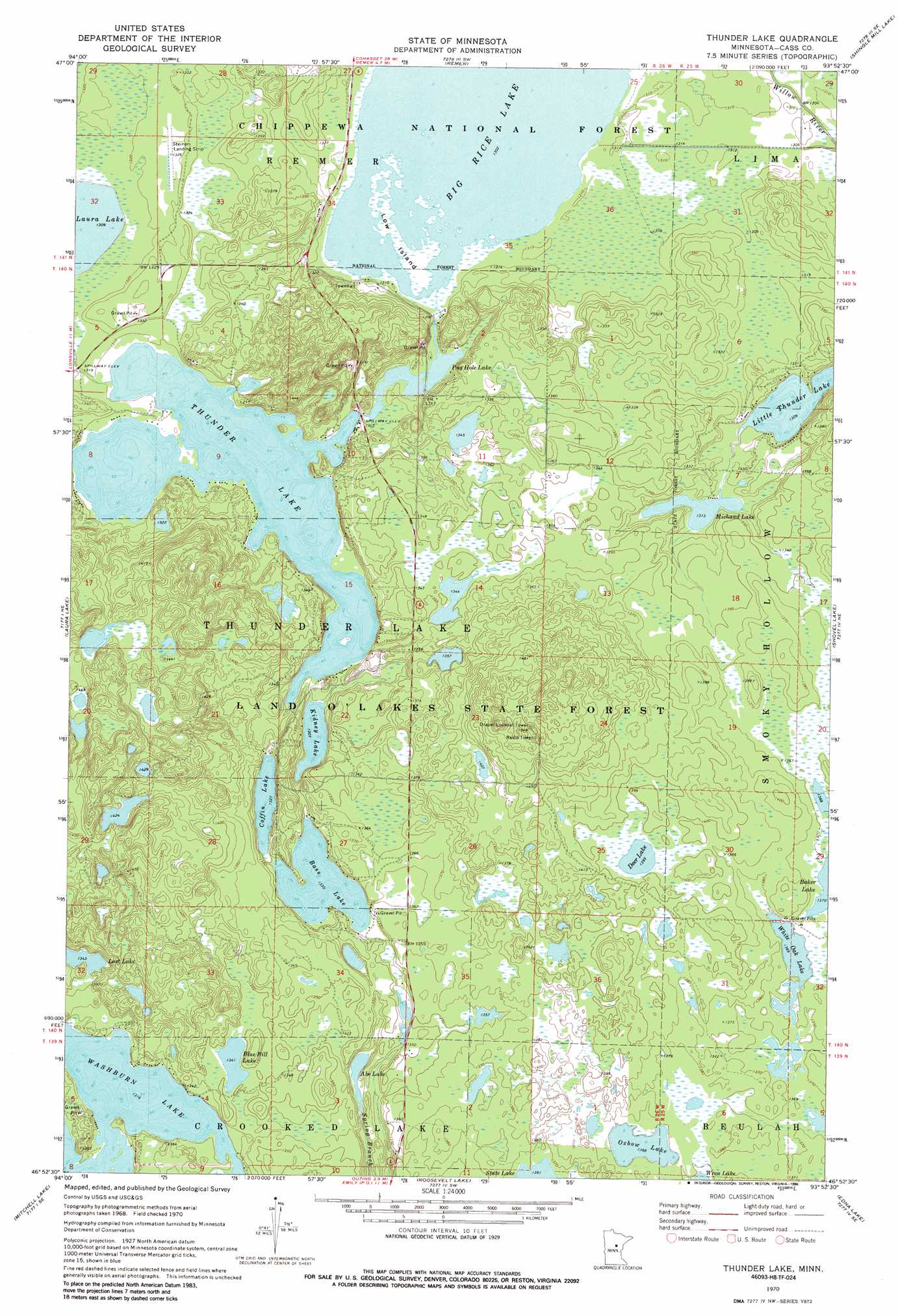
USGS Topo Quad 46093h8 - 1:24,000 scale
| Topo Map Name: | Thunder Lake |
| USGS Topo Quad ID: | 46093h8 |
| Print Size: | ca. 21 1/4" wide x 27" high |
| Southeast Coordinates: | 46.875° N latitude / 93.875° W longitude |
| Map Center Coordinates: | 46.9375° N latitude / 93.9375° W longitude |
| U.S. State: | MN |
| Filename: | o46093h8.jpg |
| Download Map JPG Image: | Thunder Lake topo map 1:24,000 scale |
| Map Type: | Topographic |
| Topo Series: | 7.5´ |
| Map Scale: | 1:24,000 |
| Source of Map Images: | United States Geological Survey (USGS) |
| Alternate Map Versions: |
Thunder Lake MN 1970, updated 1972 Download PDF Buy paper map Thunder Lake MN 1970, updated 1986 Download PDF Buy paper map Thunder Lake MN 1996, updated 1998 Download PDF Buy paper map Thunder Lake MN 2011 Download PDF Buy paper map Thunder Lake MN 2013 Download PDF Buy paper map Thunder Lake MN 2016 Download PDF Buy paper map |
| FStopo: | US Forest Service topo Thunder Lake is available: Download FStopo PDF Download FStopo TIF |
1:24,000 Topo Quads surrounding Thunder Lake
Federal Dam |
Boy River |
Goose Lake |
Sugar Lake |
Siseebakwet Lake |
Town Line Lake |
Tobique |
Remer |
Shingle Mill Lake |
Big Thunder Peak |
Longville |
Laura Lake |
Thunder Lake |
Shovel Lake |
Swatara |
Stewart Lake |
Mitchell Lake |
Roosevelt Lake |
Edna Lake |
White Elk Lake |
Lower Whitefish Lake |
Cross Lake |
Emily |
Ross Lake |
Esquagamah Lake |
> Back to 46093e1 at 1:100,000 scale
> Back to 46092a1 at 1:250,000 scale
> Back to U.S. Topo Maps home
Thunder Lake topo map: Gazetteer
Thunder Lake: Airports
Steiner Landing Strip elevation 405m 1328′Thunder Lake: Forests
Land O'Lakes State Forest elevation 414m 1358′Thunder Lake: Islands
Low Island elevation 397m 1302′Thunder Lake: Lakes
Abe Lake elevation 401m 1315′Baker Lake elevation 418m 1371′
Bass Lake elevation 406m 1332′
Big Rice Lake elevation 397m 1302′
Blue Bill Lake elevation 409m 1341′
Coffin Lake elevation 405m 1328′
Deer Lake elevation 425m 1394′
Kidney Lake elevation 399m 1309′
Michaud Lake elevation 400m 1312′
Oxbow Lake elevation 417m 1368′
Pug Hole Lake elevation 397m 1302′
White Oak Lake elevation 418m 1371′
Thunder Lake: Reservoirs
Thunder Lake elevation 402m 1318′Thunder Lake digital topo map on disk
Buy this Thunder Lake topo map showing relief, roads, GPS coordinates and other geographical features, as a high-resolution digital map file on DVD: