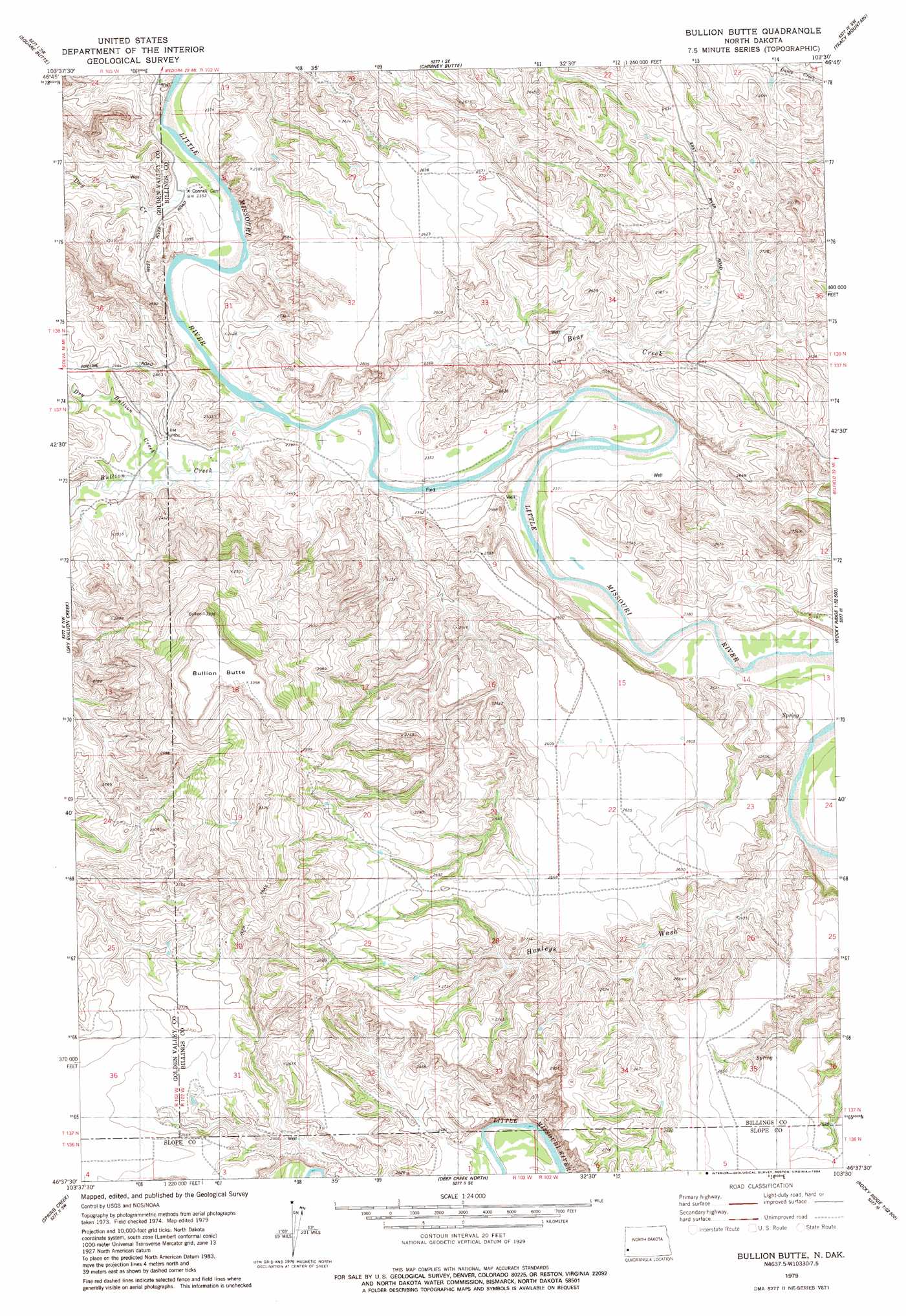
Bullion Butte Topo Map North Dakota
To zoom in, hover over the map of Bullion Butte
USGS Topo Quad 46103f5 - 1:24,000 scale
| Topo Map Name: | Bullion Butte |
| USGS Topo Quad ID: | 46103f5 |
| Print Size: | ca. 21 1/4" wide x 27" high |
| Southeast Coordinates: | 46.625° N latitude / 103.5° W longitude |
| Map Center Coordinates: | 46.6875° N latitude / 103.5625° W longitude |
| U.S. State: | ND |
| Filename: | O46103F5.jpg |
| Download Map JPG Image: | Bullion Butte topo map 1:24,000 scale |
| Map Type: | Topographic |
| Topo Series: | 7.5´ |
| Map Scale: | 1:24,000 |
| Source of Map Images: | United States Geological Survey (USGS) |
| Alternate Map Versions: |
Bullion Butte ND 1979, updated 1984 Download PDF Buy paper map Bullion Butte ND 1997, updated 2001 Download PDF Buy paper map Bullion Butte ND 2011 Download PDF Buy paper map Bullion Butte ND 2014 Download PDF Buy paper map |
| FStopo: | US Forest Service topo Bullion Butte is available: Download FStopo PDF Download FStopo TIF |
1:24,000 Topo Quads surrounding Bullion Butte
Sentinel Butte |
Buffalo Gap Campground |
Medora |
Fryburg Nw |
Fryburg Ne |
Sentinel Butte Se |
Square Butte |
Chimney Butte |
Tracy Mountain |
Fryburg |
Alpha |
Dry Bullion Creek |
Bullion Butte |
Cliffs Plateau |
Rocky Ridge North |
Three V Crossing |
Spring Creek |
Deep Creek North |
Juniper Spur |
Rocky Ridge South |
Boyce Creek West |
Boyce Creek East |
Deep Creek South |
Black Butte |
Amidon |
> Back to 46103e1 at 1:100,000 scale
> Back to 46102a1 at 1:250,000 scale
> Back to U.S. Topo Maps home
Bullion Butte topo map: Gazetteer
Bullion Butte: Springs
Black Spring elevation 924m 3031′Lime Spring elevation 934m 3064′
Bullion Butte: Streams
Bear Creek elevation 712m 2335′Bullion Creek elevation 716m 2349′
Dry Bullion Creek elevation 718m 2355′
Dry Creek elevation 709m 2326′
Hanleys Wash elevation 725m 2378′
Hanleys Wash elevation 725m 2378′
Bullion Butte: Summits
Bullion Butte elevation 1015m 3330′Bullion Butte elevation 1006m 3300′
Bullion Butte digital topo map on disk
Buy this Bullion Butte topo map showing relief, roads, GPS coordinates and other geographical features, as a high-resolution digital map file on DVD:
Eastern Montana & Western North Dakota
Buy digital topo maps: Eastern Montana & Western North Dakota