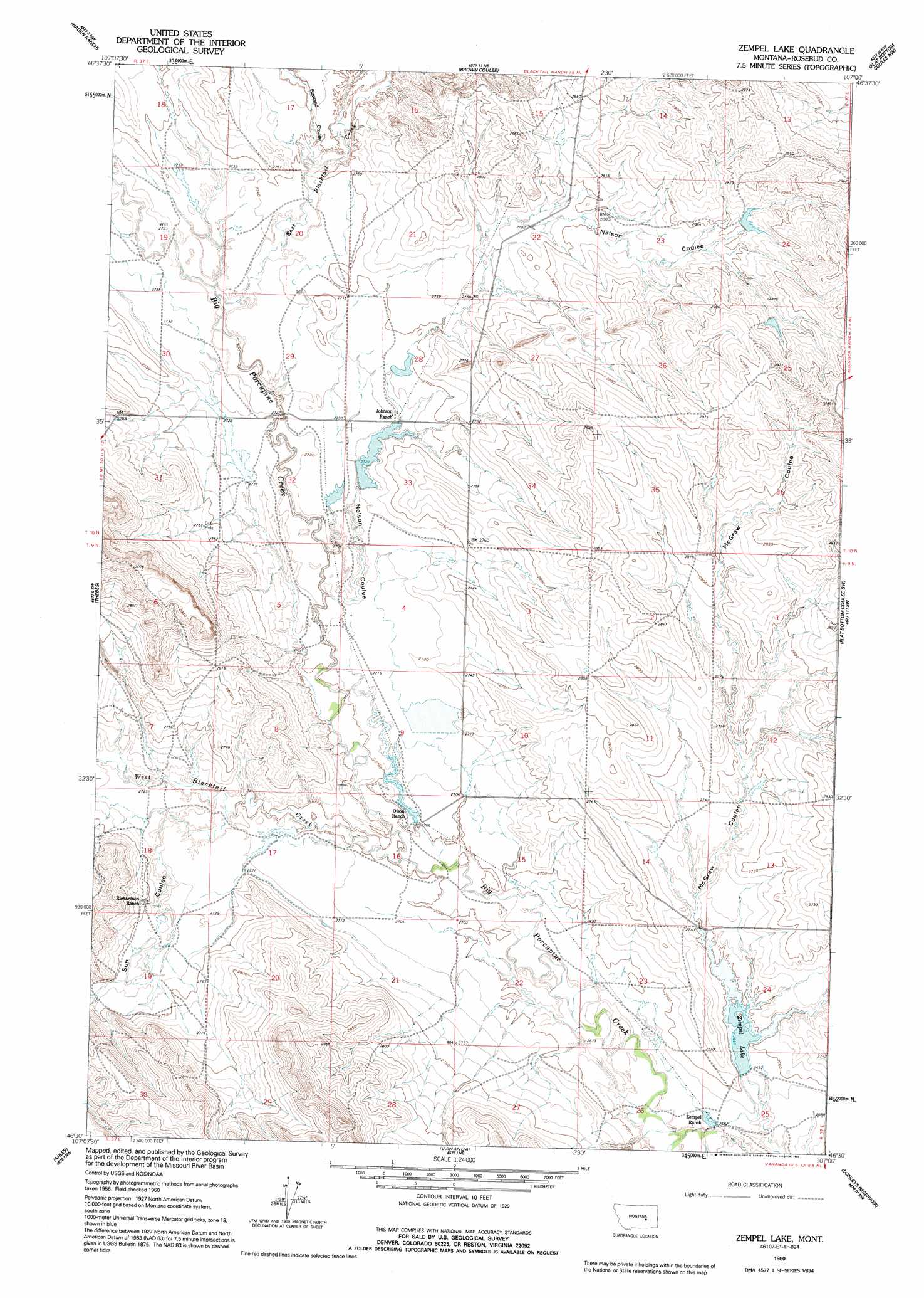
Zempel Lake Topo Map Montana
To zoom in, hover over the map of Zempel Lake
USGS Topo Quad 46107e1 - 1:24,000 scale
| Topo Map Name: | Zempel Lake |
| USGS Topo Quad ID: | 46107e1 |
| Print Size: | ca. 21 1/4" wide x 27" high |
| Southeast Coordinates: | 46.5° N latitude / 107° W longitude |
| Map Center Coordinates: | 46.5625° N latitude / 107.0625° W longitude |
| U.S. State: | MT |
| Filename: | o46107e1.jpg |
| Download Map JPG Image: | Zempel Lake topo map 1:24,000 scale |
| Map Type: | Topographic |
| Topo Series: | 7.5´ |
| Map Scale: | 1:24,000 |
| Source of Map Images: | United States Geological Survey (USGS) |
| Alternate Map Versions: |
Zempel Lake MT 1960, updated 1962 Download PDF Buy paper map Zempel Lake MT 1960, updated 1992 Download PDF Buy paper map Zempel Lake MT 2011 Download PDF Buy paper map Zempel Lake MT 2014 Download PDF Buy paper map |
1:24,000 Topo Quads surrounding Zempel Lake
Mcginnis Butte Se |
Hole-In-The-Rock |
Acorn Flats |
Vanstel |
Stellar Lake |
Black Sea Reservoir |
Hagen Ranch |
Brown Coulee |
Flat Bottom Coulee Nw |
Flat Bottom Coulee Ne |
Ingomar East |
Thebes |
Zempel Lake |
Flat Bottom Coulee Sw |
Flat Bottom Coulee Se |
Steie Ranch |
Ahles |
Vananda |
Donleys Reservoir |
Finch Ne |
Myers |
Hysham |
Sanders |
Finch |
Nichols |
> Back to 46107e1 at 1:100,000 scale
> Back to 46106a1 at 1:250,000 scale
> Back to U.S. Topo Maps home
Zempel Lake topo map: Gazetteer
Zempel Lake: Dams
B G Olson Number 1 Dam elevation 824m 2703′B G Olson Number 2 Dam elevation 824m 2703′
E L Johnson Number 1 Dam elevation 830m 2723′
Hunnes Number 1 Dam elevation 836m 2742′
J Galt Number 10 Dam elevation 826m 2709′
J Galt Number 7 Dam elevation 872m 2860′
J Galt Number 8 Dam elevation 831m 2726′
Richardson Dam elevation 842m 2762′
Z Cake Dam elevation 836m 2742′
Zempel Dam elevation 817m 2680′
Zempel Lake: Post Offices
Antelope Post Office (historical) elevation 823m 2700′Davidell Post Office (historical) elevation 854m 2801′
Zempel Lake: Reservoirs
Zempel Lake elevation 819m 2687′Zemple Lake elevation 817m 2680′
Zempel Lake: Streams
East Blacktail Creek elevation 827m 2713′East Blacktail Creek elevation 827m 2713′
West Blacktail Creek elevation 818m 2683′
Zempel Lake: Valleys
Badland Coulee elevation 833m 2732′McGraw Coulee elevation 826m 2709′
Nelson Coulee elevation 824m 2703′
Sun Coulee elevation 827m 2713′
Zempel Lake digital topo map on disk
Buy this Zempel Lake topo map showing relief, roads, GPS coordinates and other geographical features, as a high-resolution digital map file on DVD:
Eastern Montana & Western North Dakota
Buy digital topo maps: Eastern Montana & Western North Dakota