Petrolia Lake Topo Map Montana
To zoom in, hover over the map of Petrolia Lake
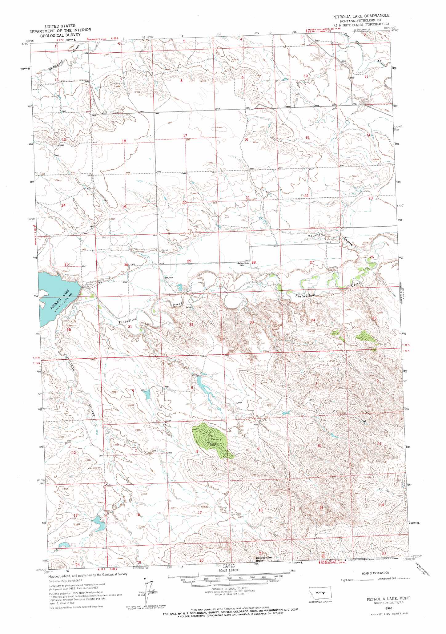
USGS Topo Quad 46108h2 - 1:24,000 scale
| Topo Map Name: | Petrolia Lake |
| USGS Topo Quad ID: | 46108h2 |
| Print Size: | ca. 21 1/4" wide x 27" high |
| Southeast Coordinates: | 46.875° N latitude / 108.125° W longitude |
| Map Center Coordinates: | 46.9375° N latitude / 108.1875° W longitude |
| U.S. State: | MT |
| Filename: | o46108h2.jpg |
| Download Map JPG Image: | Petrolia Lake topo map 1:24,000 scale |
| Map Type: | Topographic |
| Topo Series: | 7.5´ |
| Map Scale: | 1:24,000 |
| Source of Map Images: | United States Geological Survey (USGS) |
| Alternate Map Versions: |
Petrolia Lake MT 1963, updated 1966 Download PDF Buy paper map Petrolia Lake MT 2011 Download PDF Buy paper map Petrolia Lake MT 2014 Download PDF Buy paper map |
1:24,000 Topo Quads surrounding Petrolia Lake
Dry Blood Creek West |
Dry Blood Creek East |
Cat Creek Nw |
Tin Can Hill |
Bridge Coulee |
Little Bear Lake |
Winnett North |
Ingals Dam |
Cat Creek |
Fail Ranch |
Yellow Water Res. |
Winnett South |
Petrolia Lake |
Breed Spring |
Mosby |
Flatwillow |
Crowley Dam |
Kelley |
Mud Spring |
Maxwell Ranch |
Big Wall Nw |
Jim Coulee |
Musselshell Nw |
Akers Ranch |
Melstone Nw |
> Back to 46108e1 at 1:100,000 scale
> Back to 46108a1 at 1:250,000 scale
> Back to U.S. Topo Maps home
Petrolia Lake topo map: Gazetteer
Petrolia Lake: Dams
Hassett Number 1 Dam elevation 873m 2864′Hassett Number 2 Dam elevation 901m 2956′
Hassett Number 3 Dam elevation 895m 2936′
Petrolia Dam elevation 884m 2900′
Petrolia Lake: Post Offices
Smith Post Office (historical) elevation 850m 2788′Petrolia Lake: Reservoirs
Petrolia Lake elevation 884m 2900′Prtrolla Lake elevation 884m 2900′
Petrolia Lake: Valleys
Johnson Coulee elevation 880m 2887′Racehorse Coulee elevation 833m 2732′
Petrolia Lake: Wells
13N28E03CDDC01 Well elevation 954m 3129′Petrolia Lake digital topo map on disk
Buy this Petrolia Lake topo map showing relief, roads, GPS coordinates and other geographical features, as a high-resolution digital map file on DVD: