Lamb Peak Topo Map Idaho
To zoom in, hover over the map of Lamb Peak
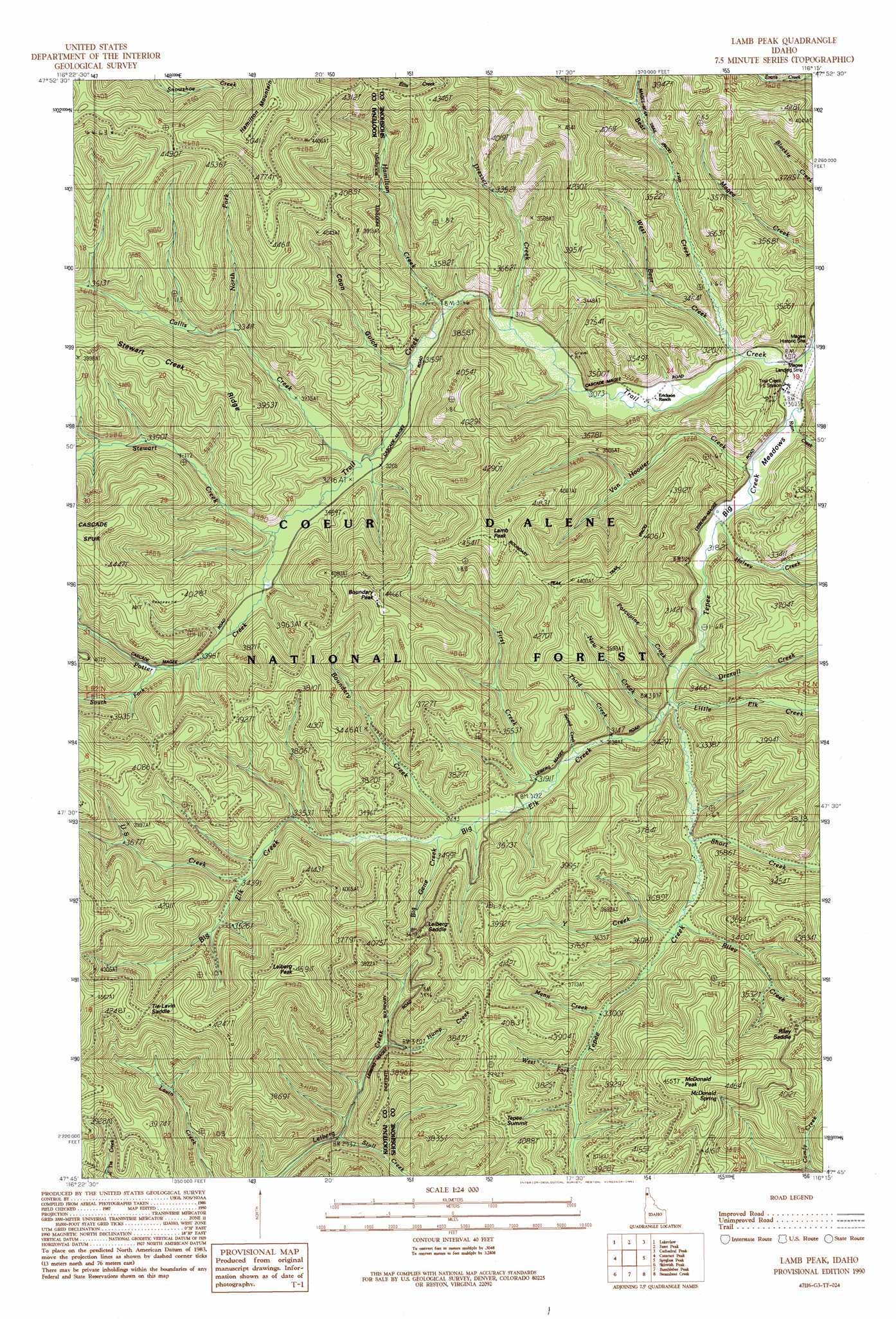
USGS Topo Quad 47116g3 - 1:24,000 scale
| Topo Map Name: | Lamb Peak |
| USGS Topo Quad ID: | 47116g3 |
| Print Size: | ca. 21 1/4" wide x 27" high |
| Southeast Coordinates: | 47.75° N latitude / 116.25° W longitude |
| Map Center Coordinates: | 47.8125° N latitude / 116.3125° W longitude |
| U.S. State: | ID |
| Filename: | o47116g3.jpg |
| Download Map JPG Image: | Lamb Peak topo map 1:24,000 scale |
| Map Type: | Topographic |
| Topo Series: | 7.5´ |
| Map Scale: | 1:24,000 |
| Source of Map Images: | United States Geological Survey (USGS) |
| Alternate Map Versions: |
Lamb Peak ID 1990, updated 1991 Download PDF Buy paper map Lamb Peak ID 1996, updated 1999 Download PDF Buy paper map Lamb Peak ID 2011 Download PDF Buy paper map Lamb Peak ID 2013 Download PDF Buy paper map |
| FStopo: | US Forest Service topo Lamb Peak is available: Download FStopo PDF Download FStopo TIF |
1:24,000 Topo Quads surrounding Lamb Peak
Cocolalla |
Minerva Peak |
Packsaddle Mountain |
Derr Point |
Cabinet |
Bayview |
Lakeview |
Faset Peak |
Cathedral Peak |
Jordan Creek |
Spades Mountain |
Cataract Peak |
Lamb Peak |
Spyglass Peak |
Pond Peak |
Wolf Lodge |
Skitwish Peak |
Bumblebee Peak |
Steamboat Creek |
Grizzly Mountain |
Lane |
Rose Lake |
Cataldo |
Kellogg West |
Kellogg East |
> Back to 47116e1 at 1:100,000 scale
> Back to 47116a1 at 1:250,000 scale
> Back to U.S. Topo Maps home
Lamb Peak topo map: Gazetteer
Lamb Peak: Airports
Magee Airport elevation 908m 2979′Lamb Peak: Flats
Big Meadows elevation 941m 3087′Lamb Peak: Forests
Coeur d'Alene National Forest elevation 1213m 3979′Lamb Peak: Gaps
Leiberg Saddle elevation 1117m 3664′Riley Saddle elevation 1206m 3956′
Tie Lavin Saddle elevation 1245m 4084′
Lamb Peak: Parks
Magee Historic Site elevation 970m 3182′Lamb Peak: Ridges
Stewart Creek Ridge elevation 1281m 4202′Lamb Peak: Springs
McDonald Spring elevation 1271m 4169′Lamb Peak: Streams
Bear Creek elevation 935m 3067′Big Elk Creek elevation 946m 3103′
Big Gene Creek elevation 993m 3257′
Boundary Creek elevation 981m 3218′
Callis Creek elevation 975m 3198′
Dresser Creek elevation 948m 3110′
Drexall Creek elevation 1013m 3323′
First Creek elevation 969m 3179′
Halsey Creek elevation 927m 3041′
Hamilton Creek elevation 958m 3143′
Hump Creek elevation 958m 3143′
Little Elk Creek elevation 949m 3113′
Mann Creek elevation 1008m 3307′
New Creek elevation 949m 3113′
North Fork Callis Creek elevation 1033m 3389′
Porcupine Creek elevation 945m 3100′
Potter Creek elevation 974m 3195′
Riley Creek elevation 982m 3221′
Ryan Creek elevation 927m 3041′
Second Creek elevation 970m 3182′
Short Creek elevation 970m 3182′
South Fork Potter Creek elevation 1044m 3425′
Stewart Creek elevation 997m 3270′
Stull Creek elevation 899m 2949′
Third Creek elevation 957m 3139′
U S Creek elevation 1081m 3546′
Van Hoosier Creek elevation 934m 3064′
West Bear Creek elevation 938m 3077′
West Fork Tepee Creek elevation 1019m 3343′
Y Creek elevation 981m 3218′
Lamb Peak: Summits
Boundary Peak elevation 1329m 4360′Hamilton Mountain elevation 1460m 4790′
Lamb Peak elevation 1376m 4514′
Leiberg Peak elevation 1428m 4685′
McDonald Peak elevation 1381m 4530′
Tepee Summit elevation 1242m 4074′
Lamb Peak: Trails
Boundary Peak Trail elevation 1293m 4242′Lamb Peak: Valleys
Coon Gulch elevation 1006m 3300′Lamb Peak digital topo map on disk
Buy this Lamb Peak topo map showing relief, roads, GPS coordinates and other geographical features, as a high-resolution digital map file on DVD: