Cathedral Peak Topo Map Idaho
To zoom in, hover over the map of Cathedral Peak
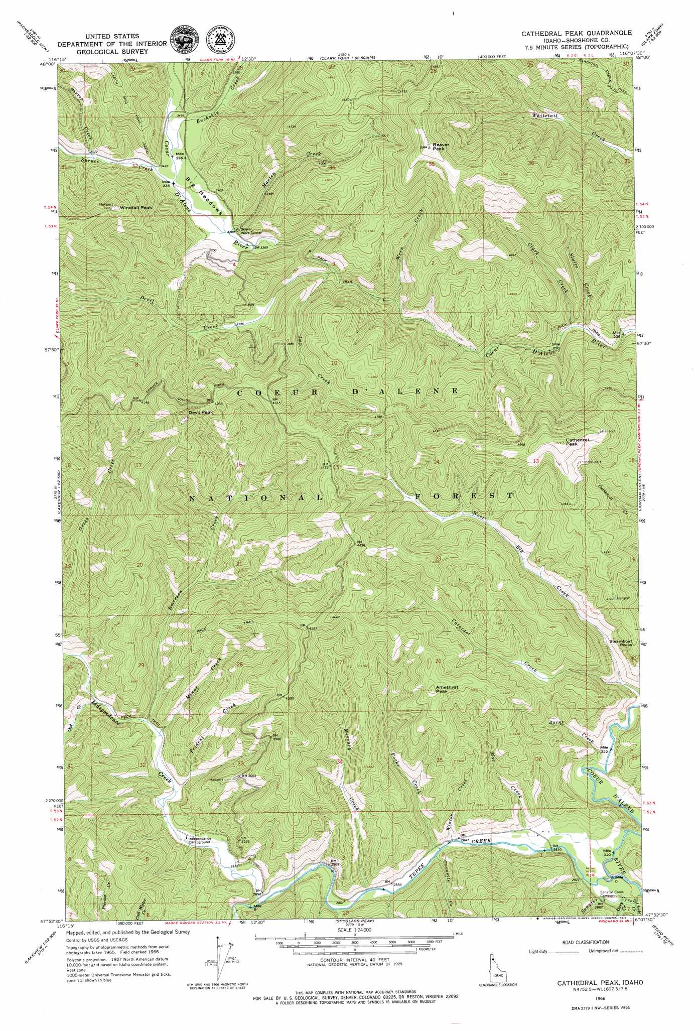
USGS Topo Quad 47116h2 - 1:24,000 scale
| Topo Map Name: | Cathedral Peak |
| USGS Topo Quad ID: | 47116h2 |
| Print Size: | ca. 21 1/4" wide x 27" high |
| Southeast Coordinates: | 47.875° N latitude / 116.125° W longitude |
| Map Center Coordinates: | 47.9375° N latitude / 116.1875° W longitude |
| U.S. State: | ID |
| Filename: | o47116h2.jpg |
| Download Map JPG Image: | Cathedral Peak topo map 1:24,000 scale |
| Map Type: | Topographic |
| Topo Series: | 7.5´ |
| Map Scale: | 1:24,000 |
| Source of Map Images: | United States Geological Survey (USGS) |
| Alternate Map Versions: |
Cathedral Peak ID 1966, updated 1971 Download PDF Buy paper map Cathedral Peak ID 1996, updated 1999 Download PDF Buy paper map Cathedral Peak ID 2011 Download PDF Buy paper map Cathedral Peak ID 2013 Download PDF Buy paper map |
| FStopo: | US Forest Service topo Cathedral Peak is available: Download FStopo PDF Download FStopo TIF |
1:24,000 Topo Quads surrounding Cathedral Peak
Talache |
Hope |
Clark Fork |
Scotchman Peak |
Sawtooth Mountain |
Minerva Peak |
Packsaddle Mountain |
Derr Point |
Cabinet |
Heron |
Lakeview |
Faset Peak |
Cathedral Peak |
Jordan Creek |
Gem Peak |
Cataract Peak |
Lamb Peak |
Spyglass Peak |
Pond Peak |
Taylor Peak |
Skitwish Peak |
Bumblebee Peak |
Steamboat Creek |
Grizzly Mountain |
Prichard |
> Back to 47116e1 at 1:100,000 scale
> Back to 47116a1 at 1:250,000 scale
> Back to U.S. Topo Maps home
Cathedral Peak topo map: Gazetteer
Cathedral Peak: Flats
Big Meadows elevation 1037m 3402′Cathedral Peak: Populated Places
Steamboat Rocks elevation 1150m 3772′Cathedral Peak: Streams
Barren Creek elevation 1054m 3458′Buckskin Creek elevation 1045m 3428′
Burnt Creek elevation 874m 2867′
Cataract Creek elevation 882m 2893′
Chute Creek elevation 860m 2821′
Clark Creek elevation 970m 3182′
Davy Creek elevation 864m 2834′
Devil Creek elevation 1013m 3323′
Emerson Creek elevation 910m 2985′
Forks Creek elevation 866m 2841′
Imp Creek elevation 1013m 3323′
Independence Creek elevation 884m 2900′
Mac Creek elevation 859m 2818′
Marten Creek elevation 1028m 3372′
Mercury Creek elevation 871m 2857′
Minor Creek elevation 909m 2982′
Opposite Creek elevation 866m 2841′
Owl Creek elevation 912m 2992′
Plant Creek elevation 876m 2874′
Senator Creek elevation 852m 2795′
Sluice Creek elevation 968m 3175′
Spruce Creek elevation 1038m 3405′
Tepee Creek elevation 854m 2801′
Trident Creek elevation 897m 2942′
West Elk Creek elevation 909m 2982′
Winton Creek elevation 864m 2834′
Wren Creek elevation 999m 3277′
Cathedral Peak: Summits
Amethyst Peak elevation 1285m 4215′Beaver Peak elevation 1638m 5374′
Cathedral Peak elevation 1501m 4924′
Devil Peak elevation 1407m 4616′
Windfall Peak elevation 1407m 4616′
Cathedral Peak: Trails
Blacktail Creek Trail elevation 1406m 4612′Cathedral Peak digital topo map on disk
Buy this Cathedral Peak topo map showing relief, roads, GPS coordinates and other geographical features, as a high-resolution digital map file on DVD: