Hale Bay Topo Map Minnesota
To zoom in, hover over the map of Hale Bay
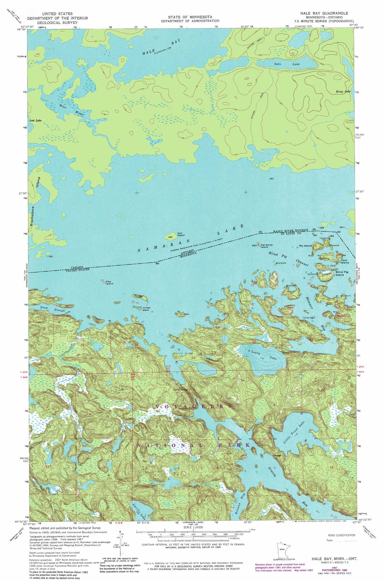
USGS Topo Quad 48092d5 - 1:24,000 scale
| Topo Map Name: | Hale Bay |
| USGS Topo Quad ID: | 48092d5 |
| Print Size: | ca. 21 1/4" wide x 27" high |
| Southeast Coordinates: | 48.375° N latitude / 92.5° W longitude |
| Map Center Coordinates: | 48.4375° N latitude / 92.5625° W longitude |
| U.S. State: | MN |
| Filename: | o48092d5.jpg |
| Download Map JPG Image: | Hale Bay topo map 1:24,000 scale |
| Map Type: | Topographic |
| Topo Series: | 7.5´ |
| Map Scale: | 1:24,000 |
| Source of Map Images: | United States Geological Survey (USGS) |
| Alternate Map Versions: |
Hale Bay MN 1967, updated 1970 Download PDF Buy paper map Hale Bay MN 1967, updated 1979 Download PDF Buy paper map Hale Bay MN 1967, updated 1983 Download PDF Buy paper map Blind Pig Island MN 2011 Download PDF Buy paper map Blind Pig Island MN 2013 Download PDF Buy paper map Blind Pig Island MN 2016 Download PDF Buy paper map |
1:24,000 Topo Quads surrounding Hale Bay
Kempton Bay |
Kettle Falls |
|||
Ash River Ne |
Namakan Island |
Hale Bay |
Redhorse Bay |
|
Ash River Se |
Marion Lake |
Johnson Lake |
Crane Lake |
Snow Bay |
Orr Ne |
Elephant Lake |
Kabustasa Lake |
Echo Lake |
Lake Jeanette |
> Back to 48092a1 at 1:100,000 scale
> Back to 48092a1 at 1:250,000 scale
> Back to U.S. Topo Maps home
Hale Bay topo map: Gazetteer
Hale Bay: Bays
Grassy Bay elevation 339m 1112′Hammer Bay elevation 339m 1112′
Hale Bay: Channels
Blind Pig Channel elevation 339m 1112′Hale Bay: Guts
Deep Slough elevation 339m 1112′Hale Bay: Islands
Blind Pig Island elevation 353m 1158′Juniper Island elevation 339m 1112′
My Island elevation 343m 1125′
Pat Smith Island elevation 343m 1125′
Pike Island elevation 343m 1125′
Your Island elevation 343m 1125′
Hale Bay: Lakes
Little Trout Lake elevation 349m 1145′Lucille Lake elevation 377m 1236′
Namakan Lake elevation 341m 1118′
O'Leary Lake elevation 347m 1138′
Hale Bay digital topo map on disk
Buy this Hale Bay topo map showing relief, roads, GPS coordinates and other geographical features, as a high-resolution digital map file on DVD: