Alexander Mountain Topo Map Montana
To zoom in, hover over the map of Alexander Mountain
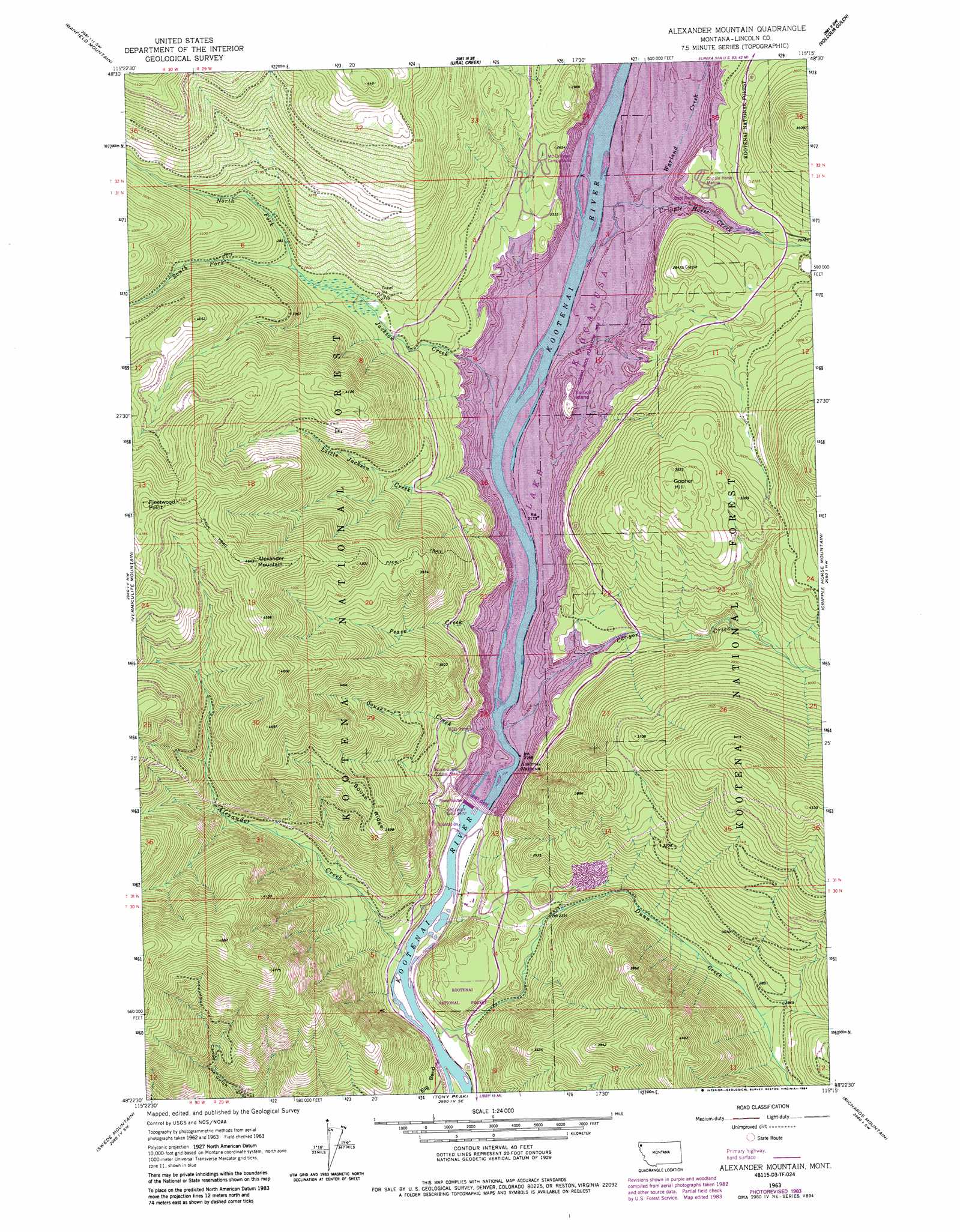
USGS Topo Quad 48115d3 - 1:24,000 scale
| Topo Map Name: | Alexander Mountain |
| USGS Topo Quad ID: | 48115d3 |
| Print Size: | ca. 21 1/4" wide x 27" high |
| Southeast Coordinates: | 48.375° N latitude / 115.25° W longitude |
| Map Center Coordinates: | 48.4375° N latitude / 115.3125° W longitude |
| U.S. State: | MT |
| Filename: | o48115d3.jpg |
| Download Map JPG Image: | Alexander Mountain topo map 1:24,000 scale |
| Map Type: | Topographic |
| Topo Series: | 7.5´ |
| Map Scale: | 1:24,000 |
| Source of Map Images: | United States Geological Survey (USGS) |
| Alternate Map Versions: |
Alexander Mountain MT 1963, updated 1966 Download PDF Buy paper map Alexander Mountain MT 1963, updated 1984 Download PDF Buy paper map Alexander Mountain MT 1997, updated 2000 Download PDF Buy paper map Alexander Mountain MT 2011 Download PDF Buy paper map Alexander Mountain MT 2014 Download PDF Buy paper map |
| FStopo: | US Forest Service topo Alexander Mountain is available: Download FStopo PDF Download FStopo TIF |
1:24,000 Topo Quads surrounding Alexander Mountain
Pink Mountain |
Parsnip Mountain |
Inch Mountain |
Mcguire Mountain |
Pinkham Mountain |
Gold Hill |
Banfield Mountain |
Ural |
Volcour |
Davis Mountain |
Libby |
Vermiculite Mountain |
Alexander Mountain |
Cripple Horse Mountain |
Warland Peak |
Little Hoodo Mountain |
Swede Mountain |
Tony Peak |
Richards Mountain |
Wolf Prairie |
Cable Mountain |
Horse Mountain |
Fisher Mountain |
Calx Mountain |
Deer Creek |
> Back to 48115a1 at 1:100,000 scale
> Back to 48114a1 at 1:250,000 scale
> Back to U.S. Topo Maps home
Alexander Mountain topo map: Gazetteer
Alexander Mountain: Dams
Libby Dam elevation 751m 2463′Alexander Mountain: Flats
Dunn Creek Flats elevation 830m 2723′Alexander Mountain: Gaps
Kootenai Narrows elevation 751m 2463′Alexander Mountain: Islands
Yarnell Island elevation 772m 2532′Alexander Mountain: Populated Places
Yarnell elevation 751m 2463′Alexander Mountain: Reservoirs
Lake Koocanusa elevation 751m 2463′Alexander Mountain: Ridges
Souse Ridge elevation 1110m 3641′Alexander Mountain: Streams
Alexander Creek elevation 647m 2122′Canyon Creek elevation 751m 2463′
Cripple Horse Creek elevation 751m 2463′
Dunn Creek elevation 646m 2119′
Jackson Creek elevation 751m 2463′
Little Jackson Creek elevation 751m 2463′
North Fork Jackson Creek elevation 851m 2791′
Peace Creek elevation 751m 2463′
Souse Creek elevation 751m 2463′
South Fork Jackson Creek elevation 850m 2788′
Warland Creek elevation 751m 2463′
Alexander Mountain: Summits
Alexander Mountain elevation 1413m 4635′Fleetwood Point elevation 1468m 4816′
Gopher Hill elevation 1086m 3562′
Alexander Mountain digital topo map on disk
Buy this Alexander Mountain topo map showing relief, roads, GPS coordinates and other geographical features, as a high-resolution digital map file on DVD: