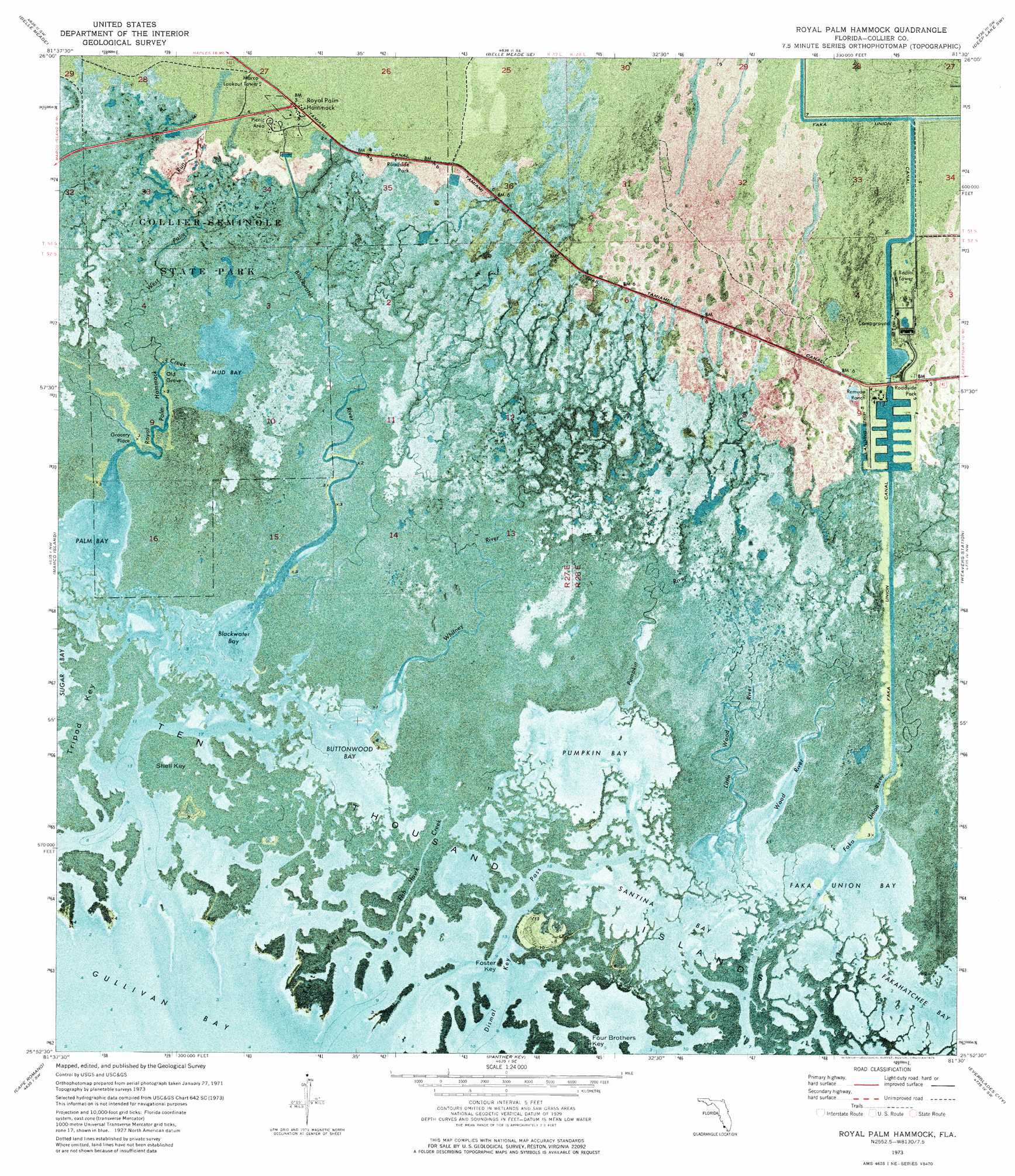
Royal Palm Hammock Topo Map Florida
To zoom in, hover over the map of Royal Palm Hammock
USGS Topo Quad 25081h5 - 1:24,000 scale
| Topo Map Name: | Royal Palm Hammock |
| USGS Topo Quad ID: | 25081h5 |
| Print Size: | ca. 21 1/4" wide x 27" high |
| Southeast Coordinates: | 25.875° N latitude / 81.5° W longitude |
| Map Center Coordinates: | 25.9375° N latitude / 81.5625° W longitude |
| U.S. State: | FL |
| Filename: | P25081H5.jpg |
| Download Map JPG Image: | Royal Palm Hammock topo map 1:24,000 scale |
| Map Type: | Orthophoto |
| Topo Series: | 7.5´ |
| Map Scale: | 1:24,000 |
| Source of Map Images: | United States Geological Survey (USGS) |
| Alternate Map Versions: |
Royal Palm Hammock FL 1973, updated 1976 Download PDF Buy paper map Royal Palm Hammock FL 2012 Download PDF Buy paper map Royal Palm Hammock FL 2015 Download PDF Buy paper map |
1:24,000 Topo Quads surrounding Royal Palm Hammock
Naples North |
Belle Meade Nw |
Belle Meade Ne |
Catherine Island |
Miles City |
Naples South |
Belle Meade |
Belle Meade Se |
Deep Lake Sw |
Deep Lake |
Marco Island |
Royal Palm Hammock |
Weavers Station |
Ochopee |
|
Cape Romano |
Panther Key |
Everglades City |
Chokoloskee |
|
Pavilion Key |
> Back to 25081e1 at 1:100,000 scale
> Back to 25080a1 at 1:250,000 scale
> Back to U.S. Topo Maps home
Royal Palm Hammock topo map: Gazetteer
Royal Palm Hammock: Airports
Port of the Islands Airport elevation 1m 3′Royal Palm Hammock: Bars
Long Rock elevation 0m 0′Royal Palm Hammock: Bays
Blackwater Bay elevation 0m 0′Buttonwood Bay elevation 0m 0′
Coffeepot Cove elevation 0m 0′
Faka Union Bay elevation 0m 0′
Gator Bay elevation 0m 0′
Ghost Cove elevation 0m 0′
Mud Bay elevation 0m 0′
Palm Bay elevation 0m 0′
Pumpkin Bay elevation 0m 0′
Santina Bay elevation 0m 0′
Shell Key Bay elevation 0m 0′
Turtle Bay elevation 0m 0′
Royal Palm Hammock: Canals
Faka Union Canal elevation 0m 0′Royal Palm Hammock: Channels
Coon Gravy Gate elevation 0m 0′Dismal Key Pass elevation 0m 0′
Fakahatchee Pass elevation 0m 0′
Gill Rattle Creek elevation 0m 0′
Middle Channel elevation 0m 0′
Southwest Gate elevation 0m 0′
Whitney Channel elevation 0m 0′
Royal Palm Hammock: Guts
Fish Hawk Creek elevation 0m 0′Royal Palm Hammock Creek elevation 0m 0′
Royal Palm Hammock: Islands
Brush Island elevation 0m 0′Buttonwood Island elevation 1m 3′
Camp Key elevation 0m 0′
Foster Key elevation 0m 0′
Four Brothers Key elevation 0m 0′
Jackfish Island elevation 0m 0′
Shell Key elevation 0m 0′
Turtle Key elevation 0m 0′
Royal Palm Hammock: Parks
Collier-Seminole State Park elevation 0m 0′Royal Palm Hammock: Populated Places
Dismal Key elevation 1m 3′Grocery Place elevation 0m 0′
Old Grove elevation 0m 0′
Royal Palm Hammock elevation 1m 3′
Royal Palm Hammock: Streams
Blackwater River elevation 0m 0′Little Wood River elevation 0m 0′
Pumpkin River elevation 0m 0′
West Palm Run elevation 0m 0′
Whitney River elevation 0m 0′
Wood River elevation 0m 0′
Royal Palm Hammock digital topo map on disk
Buy this Royal Palm Hammock topo map showing relief, roads, GPS coordinates and other geographical features, as a high-resolution digital map file on DVD: