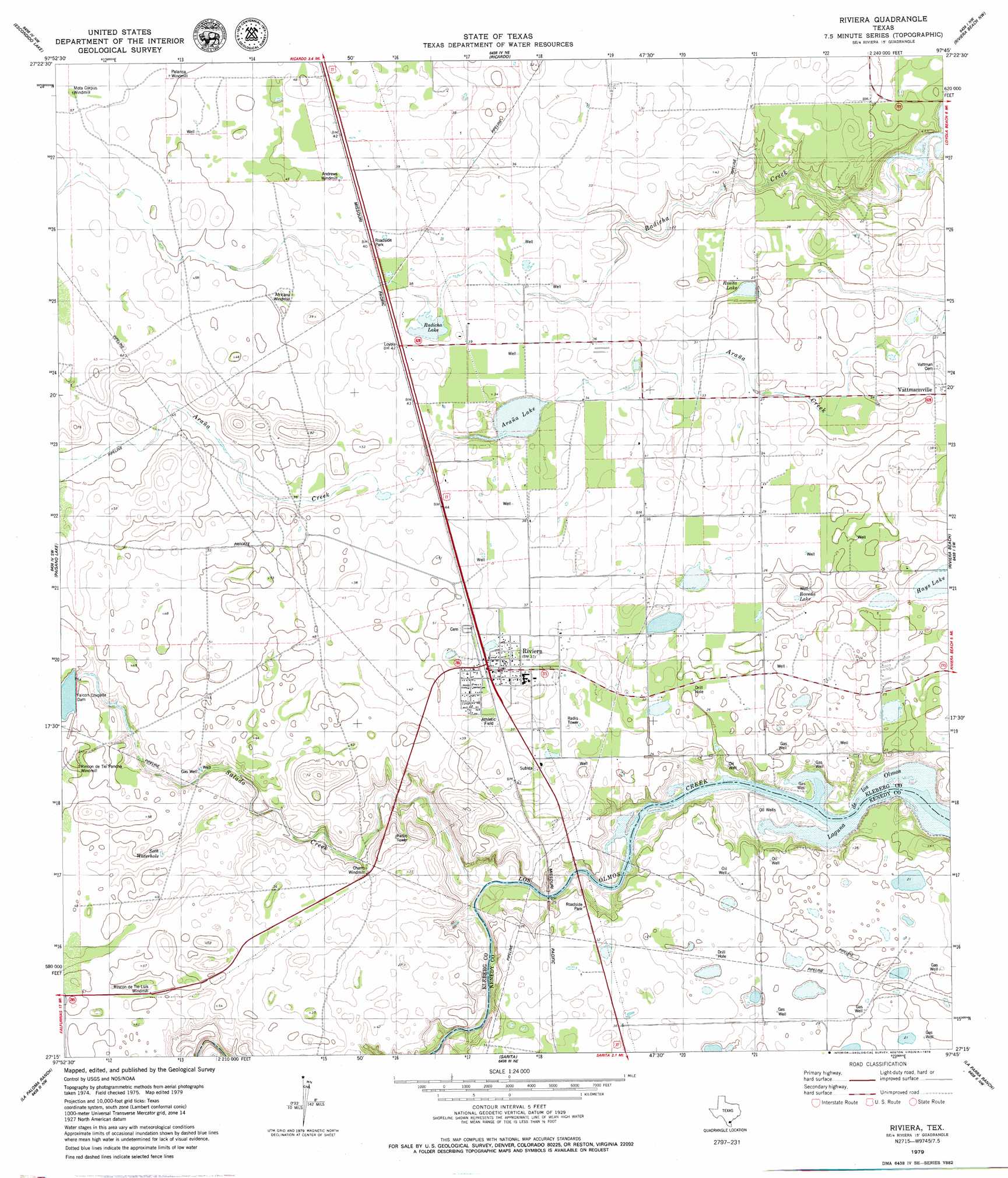
Riviera Topo Map Texas
To zoom in, hover over the map of Riviera
USGS Topo Quad 27097c7 - 1:24,000 scale
| Topo Map Name: | Riviera |
| USGS Topo Quad ID: | 27097c7 |
| Print Size: | ca. 21 1/4" wide x 27" high |
| Southeast Coordinates: | 27.25° N latitude / 97.75° W longitude |
| Map Center Coordinates: | 27.3125° N latitude / 97.8125° W longitude |
| U.S. State: | TX |
| Filename: | o27097c7.jpg |
| Download Map JPG Image: | Riviera topo map 1:24,000 scale |
| Map Type: | Topographic |
| Topo Series: | 7.5´ |
| Map Scale: | 1:24,000 |
| Source of Map Images: | United States Geological Survey (USGS) |
| Alternate Map Versions: |
Riviera TX 1979, updated 1979 Download PDF Buy paper map Riviera TX 2010 Download PDF Buy paper map Riviera TX 2013 Download PDF Buy paper map Riviera TX 2016 Download PDF Buy paper map |
1:24,000 Topo Quads surrounding Riviera
Ben Bolt Se |
Kingsville West |
Kingsville East |
Concordia |
Laureles Ranch |
Ella |
Escondido Lake |
Ricardo |
Riviera Beach Nw |
Riviera Beach Ne |
Premont East |
Paisano Lake |
Riviera |
Riviera Beach |
Kleberg Point |
Flowella |
La Paloma Ranch |
Sarita |
La Parra Ranch |
La Parra Ranch Ne |
Falfurrias Se |
Sarita Sw |
Turcotte |
La Parra Ranch Sw |
La Parra Ranch Se |
> Back to 27097a1 at 1:100,000 scale
> Back to 27096a1 at 1:250,000 scale
> Back to U.S. Topo Maps home
Riviera topo map: Gazetteer
Riviera: Dams
Falcon Chiquita Dam elevation 15m 49′King Ranch Dam Number 1 elevation 15m 49′
Riviera: Lakes
Araña Lake elevation 8m 26′Boveda Lake elevation 5m 16′
Hays Lake elevation 5m 16′
Radicha Lake elevation 10m 32′
Riviera: Populated Places
Riviera elevation 13m 42′Vattmannville elevation 8m 26′
Riviera: Reservoirs
Reservoir Number 1 elevation 15m 49′Rosita Lake elevation 8m 26′
Seth Waterhole elevation 12m 39′
Riviera: Streams
Salado Creek elevation 0m 0′Riviera digital topo map on disk
Buy this Riviera topo map showing relief, roads, GPS coordinates and other geographical features, as a high-resolution digital map file on DVD: