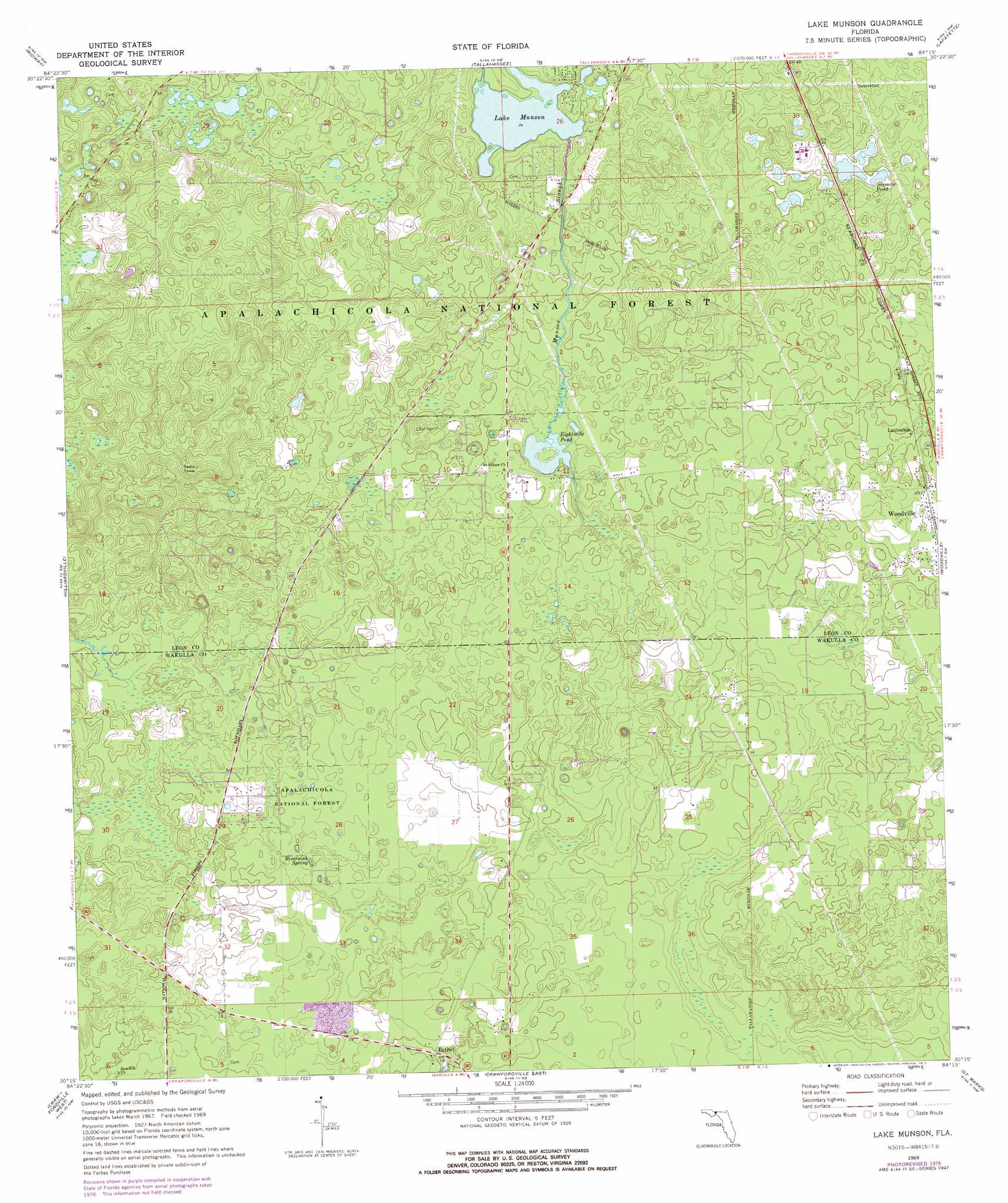
Lake Munson Topo Map Florida
To zoom in, hover over the map of Lake Munson
USGS Topo Quad 30084c3 - 1:24,000 scale
| Topo Map Name: | Lake Munson |
| USGS Topo Quad ID: | 30084c3 |
| Print Size: | ca. 21 1/4" wide x 27" high |
| Southeast Coordinates: | 30.25° N latitude / 84.25° W longitude |
| Map Center Coordinates: | 30.3125° N latitude / 84.3125° W longitude |
| U.S. State: | FL |
| Filename: | O30084C3.jpg |
| Download Map JPG Image: | Lake Munson topo map 1:24,000 scale |
| Map Type: | Topographic |
| Topo Series: | 7.5´ |
| Map Scale: | 1:24,000 |
| Source of Map Images: | United States Geological Survey (USGS) |
| Alternate Map Versions: |
Lake Munson FL 1969, updated 1972 Download PDF Buy paper map Lake Munson FL 1969, updated 1977 Download PDF Buy paper map Lake Munson FL 1999, updated 2003 Download PDF Buy paper map Lake Munson FL 2012 Download PDF Buy paper map Lake Munson FL 2015 Download PDF Buy paper map |
| FStopo: | US Forest Service topo Lake Munson is available: Download FStopo PDF Download FStopo TIF |
1:24,000 Topo Quads surrounding Lake Munson
Quincy |
Havana South |
Lake Jackson |
Bradfordville |
Miccosukee |
Lake Talquin |
Midway |
Tallahassee |
Lafayette |
Lloyd |
Lake Talquin Se |
Hilliardville |
Lake Munson |
Woodville |
Cody |
Bradwell Bay |
Crawfordville West |
Crawfordville East |
Saint Marks |
Saint Marks Ne |
Sanborn |
Sopchoppy |
Spring Creek |
Sprague Island |
Cobb Rocks |
> Back to 30084a1 at 1:100,000 scale
> Back to 30084a1 at 1:250,000 scale
> Back to U.S. Topo Maps home
Lake Munson topo map: Gazetteer
Lake Munson: Basins
Blue Sink elevation 7m 22′Lake Munson: Lakes
Eightmile Pond elevation 4m 13′Lake Munson elevation 7m 22′
Sixmile Pond elevation 7m 22′
Lake Munson: Parks
Leon Sinks Geological Area elevation 8m 26′Lake Munson: Populated Places
Bethel elevation 6m 19′Lutterloh elevation 7m 22′
Lake Munson: Springs
Riversink Spring elevation 4m 13′Lake Munson: Streams
Fisher Creek elevation 6m 19′Munson Slough elevation 2m 6′
Lake Munson digital topo map on disk
Buy this Lake Munson topo map showing relief, roads, GPS coordinates and other geographical features, as a high-resolution digital map file on DVD:
Gulf Coast (LA, MS, AL, FL) & Southwestern Georgia
Buy digital topo maps: Gulf Coast (LA, MS, AL, FL) & Southwestern Georgia
 & Southwestern Georgia map DVD")