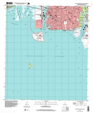
Pascagoula South Topo Map Mississippi
To zoom in, hover over the map of Pascagoula South
USGS Topo Quad 30088c5 - 1:24,000 scale
| Topo Map Name: | Pascagoula South |
| USGS Topo Quad ID: | 30088c5 |
| Print Size: | ca. 21 1/4" wide x 27" high |
| Southeast Coordinates: | 30.25° N latitude / 88.5° W longitude |
| Map Center Coordinates: | 30.3125° N latitude / 88.5625° W longitude |
| U.S. State: | MS |
| Filename: | o30088c5.jpg |
| Download Map JPG Image: | Pascagoula South topo map 1:24,000 scale |
| Map Type: | Topographic |
| Topo Series: | 7.5´ |
| Map Scale: | 1:24,000 |
| Source of Map Images: | United States Geological Survey (USGS) |
| Alternate Map Versions: |
Pascagoula South MS 1982, updated 1982 Download PDF Buy paper map Pascagoula South MS 1982, updated 1982 Download PDF Buy paper map Pascagoula South MS 1996, updated 1999 Download PDF Buy paper map Pascagoula South MS 2012 Download PDF Buy paper map Pascagoula South MS 2015 Download PDF Buy paper map |
1:24,000 Topo Quads surrounding Pascagoula South
> Back to 30088a1 at 1:100,000 scale
> Back to 30088a1 at 1:250,000 scale
> Back to U.S. Topo Maps home
Pascagoula South topo map: Gazetteer
Pascagoula South: Airports
Singing River Hospital Airport elevation 4m 13′Pascagoula South: Bays
Lac La Buche elevation 0m 0′Mississippi Sound elevation 0m 0′
Pascagoula Bay elevation 0m 0′
Railroad Corner elevation 0m 0′
Pascagoula South: Bridges
Singing River Bridge elevation 1m 3′Pascagoula South: Capes
Point Tuasaine elevation 1m 3′Spanish Point elevation 3m 9′
Pascagoula South: Channels
Bayou Cassotte Channel elevation 0m 0′Pascagoula Channel elevation 0m 0′
Pascagoula Channel elevation 0m 0′
Pascagoula South: Gaps
The Gap elevation 0m 0′Pascagoula South: Guts
Back Bayou elevation 2m 6′Belle Fontaine Bayu elevation 1m 3′
Delmas Bayou elevation 1m 3′
Dredge Bayou (historical) elevation 1m 3′
Pascagoula South: Islands
Greenwood Island elevation 0m 0′Rabbit Island elevation 1m 3′
Round Island elevation 1m 3′
Singing River Island elevation 5m 16′
Twin Islands elevation 1m 3′
Pascagoula South: Lakes
Irvin Lake elevation 1m 3′Lake Yazoo elevation 0m 0′
Pascagoula South: Parks
I G Levy Memorial Park elevation 3m 9′Joggers Park elevation 3m 9′
Longfellow House National Historical Site elevation 2m 6′
Pascagoula Beach Park and Recreation Area elevation 1m 3′
Pascagoula River Front Park elevation 1m 3′
Pine Street Park elevation 3m 9′
Pascagoula South: Populated Places
East Pascagoula elevation 3m 9′East Side elevation 4m 13′
Pascagoula elevation 3m 9′
South Pascagoula elevation 3m 9′
Pascagoula South: Reservoirs
Blue Lake elevation 3m 9′Pascagoula South: Streams
Bayou Casotte elevation 0m 0′Bayou Chico elevation 0m 0′
Comynie Bayou elevation 2m 6′
Middle River elevation 0m 0′
Pascagoula River elevation 0m 0′
Singing River elevation 0m 0′
West Pascagoula River elevation 0m 0′
West Prong Bayou Casotte elevation 1m 3′
West River elevation 0m 0′
Pascagoula South digital topo map on disk
Buy this Pascagoula South topo map showing relief, roads, GPS coordinates and other geographical features, as a high-resolution digital map file on DVD:
Gulf Coast (LA, MS, AL, FL) & Southwestern Georgia
Buy digital topo maps: Gulf Coast (LA, MS, AL, FL) & Southwestern Georgia


