Grand Bay Sw Topo Map Mississippi
To zoom in, hover over the map of Grand Bay Sw
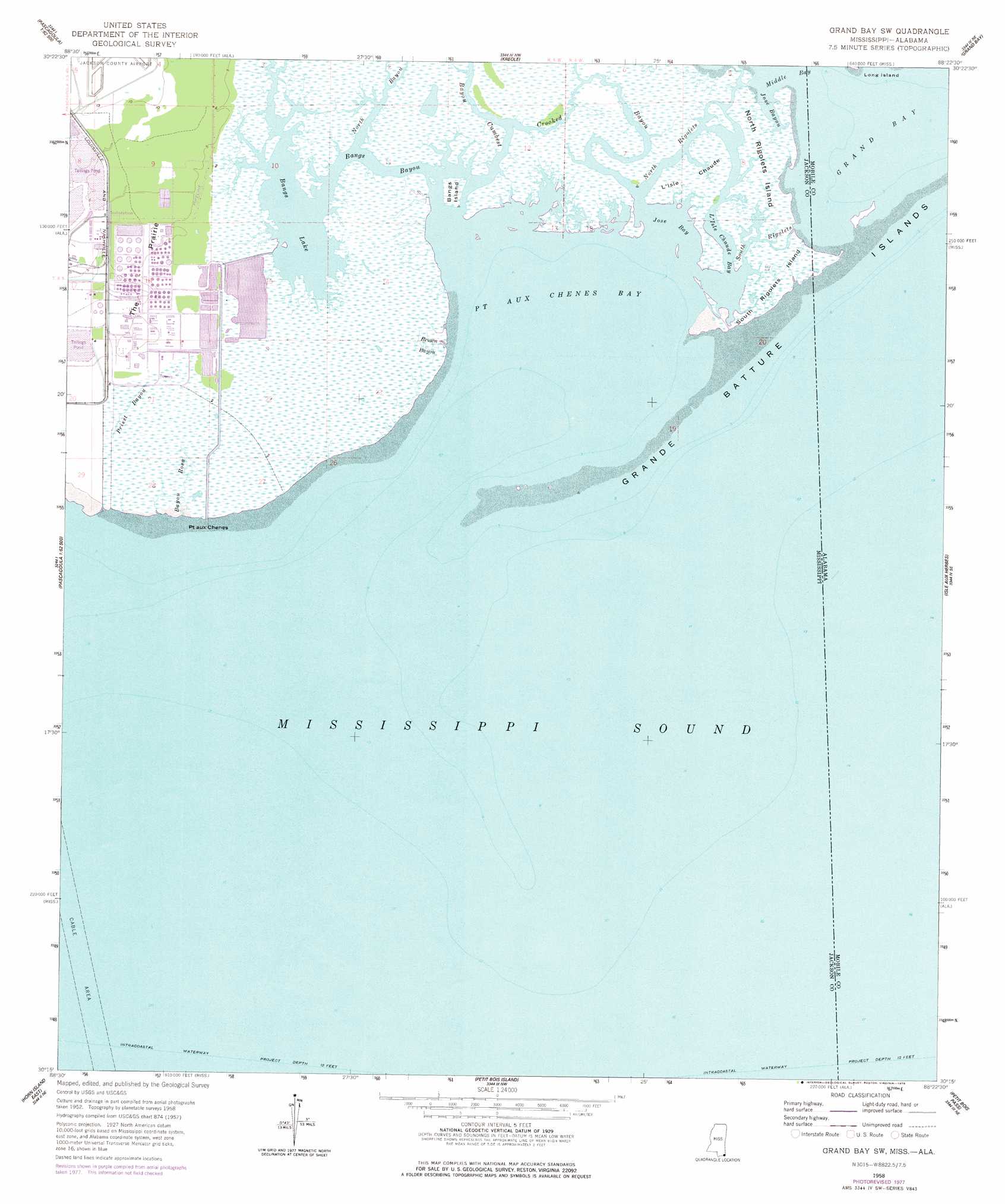
USGS Topo Quad 30088c4 - 1:24,000 scale
| Topo Map Name: | Grand Bay Sw |
| USGS Topo Quad ID: | 30088c4 |
| Print Size: | ca. 21 1/4" wide x 27" high |
| Southeast Coordinates: | 30.25° N latitude / 88.375° W longitude |
| Map Center Coordinates: | 30.3125° N latitude / 88.4375° W longitude |
| U.S. States: | MS, AL |
| Filename: | o30088c4.jpg |
| Download Map JPG Image: | Grand Bay Sw topo map 1:24,000 scale |
| Map Type: | Topographic |
| Topo Series: | 7.5´ |
| Map Scale: | 1:24,000 |
| Source of Map Images: | United States Geological Survey (USGS) |
| Alternate Map Versions: |
Grand Bay SW AL 1958, updated 1959 Download PDF Buy paper map Grand Bay SW AL 1958, updated 1972 Download PDF Buy paper map Grand Bay SW AL 1958, updated 1978 Download PDF Buy paper map Grand Bay SW AL 2011 Download PDF Buy paper map Grand Bay SW AL 2014 Download PDF Buy paper map |
1:24,000 Topo Quads surrounding Grand Bay Sw
Vancleave |
Three Rivers |
Big Point |
Saint Elmo |
Theodore |
Gautier North |
Pascagoula North |
Kreole |
Grand Bay |
Coden |
Gautier South |
Pascagoula South |
Grand Bay Sw |
Isle Aux Herbes |
Heron Bay |
Horn Island West |
Horn Island East |
Petit Bois Island |
Petit Bois Pass |
Fort Morgan Nw |
> Back to 30088a1 at 1:100,000 scale
> Back to 30088a1 at 1:250,000 scale
> Back to U.S. Topo Maps home
Grand Bay Sw topo map: Gazetteer
Grand Bay Sw: Bays
Grand Bay elevation 0m 0′Jose Bay elevation 0m 0′
Point Aux Chenes Bay elevation 0m 0′
Grand Bay Sw: Capes
Point Aux Chenes elevation 1m 3′Grand Bay Sw: Flats
The Prairie elevation 2m 6′Grand Bay Sw: Guts
Bangs Bayou elevation 0m 0′Crooked Bayou elevation 0m 0′
Jose Bayou elevation 0m 0′
L'Isle Chaude Bay elevation 0m 0′
North Rigolets elevation 1m 3′
South Rigolets elevation 0m 0′
Grand Bay Sw: Islands
Bangs Island elevation 0m 0′Grande Batture Islands elevation 0m 0′
Grande Batture Islands elevation 0m 0′
L'Isle Chaude elevation 0m 0′
North Rigolets Island elevation 1m 3′
South Rigolets Island elevation 0m 0′
South Rigolets Island elevation 1m 3′
Grand Bay Sw: Lakes
Bangs Lake elevation 0m 0′Grand Bay Sw: Streams
Bayou Cumbest elevation 0m 0′Bayou Rosa elevation 0m 0′
Brown Bayou elevation 0m 0′
North Bayou elevation 1m 3′
Priest Bayou elevation 1m 3′
Grand Bay Sw digital topo map on disk
Buy this Grand Bay Sw topo map showing relief, roads, GPS coordinates and other geographical features, as a high-resolution digital map file on DVD:
Gulf Coast (LA, MS, AL, FL) & Southwestern Georgia
Buy digital topo maps: Gulf Coast (LA, MS, AL, FL) & Southwestern Georgia
 & Southwestern Georgia map DVD")