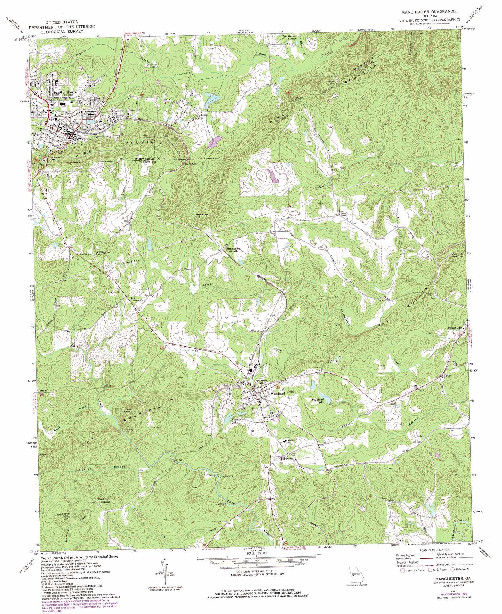
Manchester Topo Map Georgia
To zoom in, hover over the map of Manchester
USGS Topo Quad 32084g5 - 1:24,000 scale
| Topo Map Name: | Manchester |
| USGS Topo Quad ID: | 32084g5 |
| Print Size: | ca. 21 1/4" wide x 27" high |
| Southeast Coordinates: | 32.75° N latitude / 84.5° W longitude |
| Map Center Coordinates: | 32.8125° N latitude / 84.5625° W longitude |
| U.S. State: | GA |
| Filename: | o32084g5.jpg |
| Download Map JPG Image: | Manchester topo map 1:24,000 scale |
| Map Type: | Topographic |
| Topo Series: | 7.5´ |
| Map Scale: | 1:24,000 |
| Source of Map Images: | United States Geological Survey (USGS) |
| Alternate Map Versions: |
Manchester GA 1971, updated 1973 Download PDF Buy paper map Manchester GA 1971, updated 1986 Download PDF Buy paper map Manchester GA 2011 Download PDF Buy paper map Manchester GA 2014 Download PDF Buy paper map |
1:24,000 Topo Quads surrounding Manchester
Odessadale |
Greenville |
Gay |
Concord |
Zebulon |
Durand |
Warm Springs |
Woodbury |
Sunset Village |
Thomaston |
Pine Mountain |
Shiloh |
Manchester |
Roland |
Lincoln Park |
Cataula |
Waverly Hall |
Talbotton |
Baldwinville |
Prattsburg |
Midland |
Upatoi |
Geneva |
Junction City |
Butler West |
> Back to 32084e1 at 1:100,000 scale
> Back to 32084a1 at 1:250,000 scale
> Back to U.S. Topo Maps home
Manchester topo map: Gazetteer
Manchester: Crossings
Rocky Shoals Ford elevation 185m 606′Manchester: Dams
Copeland Lake Dam elevation 229m 751′Pine Mountain Foundation Dam elevation 222m 728′
Woodland Lake Dam elevation 216m 708′
Manchester: Gaps
Dunn Gap elevation 294m 964′Helm Gap elevation 191m 626′
Johnson Gap elevation 310m 1017′
Milen Gap elevation 322m 1056′
Mitchell Gap elevation 261m 856′
Patrick Gap elevation 274m 898′
Stephenson Gap elevation 299m 980′
Manchester: Lakes
Ransome Lake elevation 197m 646′Manchester: Populated Places
Belleview elevation 232m 761′Chalybeate Springs elevation 245m 803′
Cunningham Crossroads elevation 251m 823′
Greens Mill elevation 176m 577′
Hawkins Crossroads elevation 230m 754′
Manchester elevation 266m 872′
Tax Crossroads elevation 254m 833′
Woodland elevation 234m 767′
Manchester: Post Offices
Manchester Post Office elevation 268m 879′Manchester: Reservoirs
Copeland Lake elevation 229m 751′Pine Mountain Foundation Lake elevation 222m 728′
Woodland Lake elevation 216m 708′
Manchester: Springs
Tom Brown Spring elevation 231m 757′Manchester: Streams
Gin Creek elevation 164m 538′Hurricane Branch elevation 227m 744′
Mahone Branch elevation 182m 597′
Rush Creek elevation 193m 633′
Tom Brown Branch elevation 218m 715′
Manchester: Summits
Turkey Knob elevation 300m 984′Manchester digital topo map on disk
Buy this Manchester topo map showing relief, roads, GPS coordinates and other geographical features, as a high-resolution digital map file on DVD:
Gulf Coast (LA, MS, AL, FL) & Southwestern Georgia
Buy digital topo maps: Gulf Coast (LA, MS, AL, FL) & Southwestern Georgia
 & Southwestern Georgia map DVD")