Organ Topo Map New Mexico
To zoom in, hover over the map of Organ
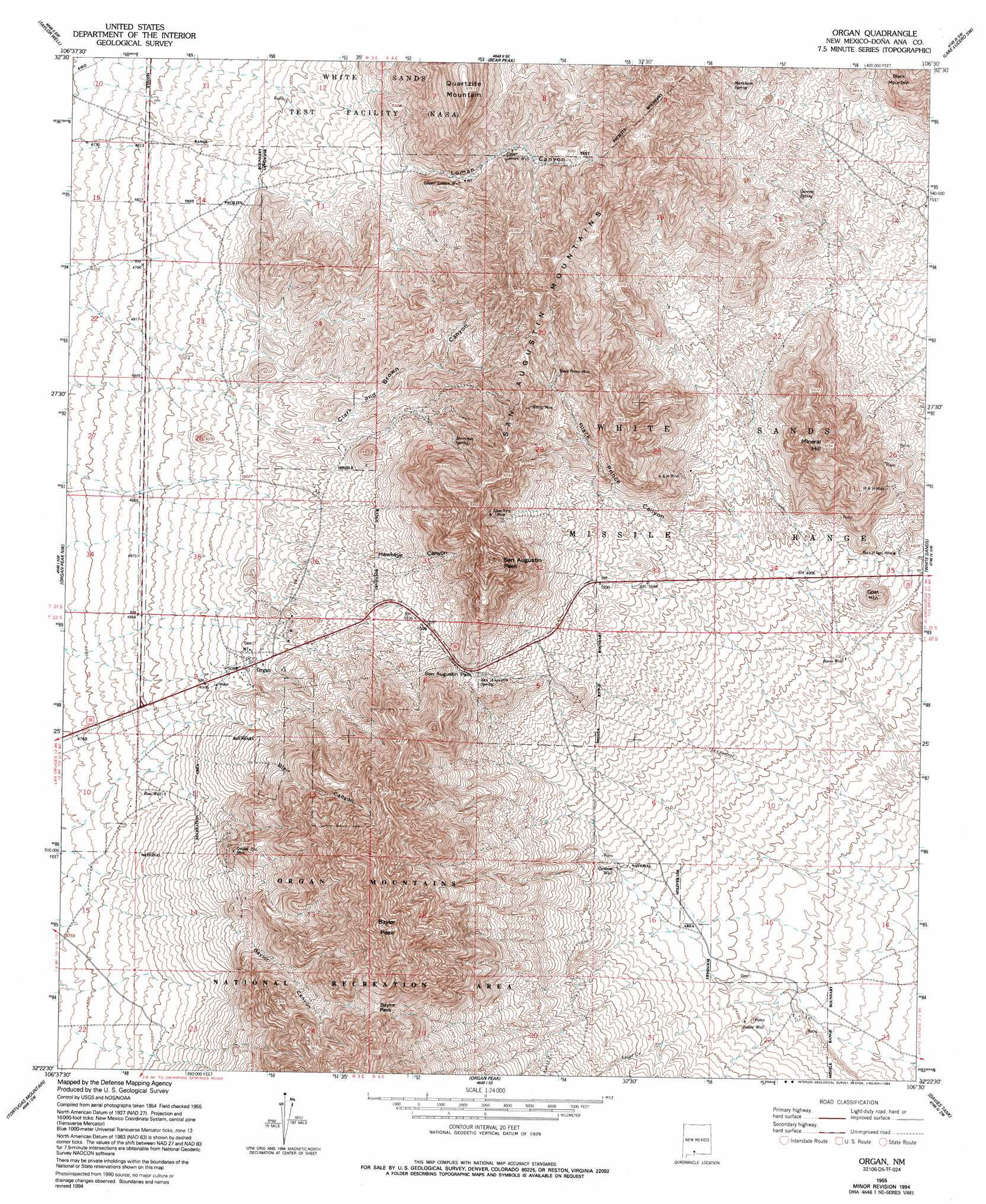
USGS Topo Quad 32106d5 - 1:24,000 scale
| Topo Map Name: | Organ |
| USGS Topo Quad ID: | 32106d5 |
| Print Size: | ca. 21 1/4" wide x 27" high |
| Southeast Coordinates: | 32.375° N latitude / 106.5° W longitude |
| Map Center Coordinates: | 32.4375° N latitude / 106.5625° W longitude |
| U.S. State: | NM |
| Filename: | o32106d5.jpg |
| Download Map JPG Image: | Organ topo map 1:24,000 scale |
| Map Type: | Topographic |
| Topo Series: | 7.5´ |
| Map Scale: | 1:24,000 |
| Source of Map Images: | United States Geological Survey (USGS) |
| Alternate Map Versions: |
Organ NM 1955, updated 1962 Download PDF Buy paper map Organ NM 1955, updated 1978 Download PDF Buy paper map Organ NM 1955, updated 1983 Download PDF Buy paper map Organ NM 1955, updated 1994 Download PDF Buy paper map Organ NM 1996, updated 2002 Download PDF Buy paper map Organ NM 2010 Download PDF Buy paper map Organ NM 2013 Download PDF Buy paper map Organ NM 2017 Download PDF Buy paper map |
1:24,000 Topo Quads surrounding Organ
Seldon Canyon Ne |
Goldenburg Draw |
San Andres Peak |
Lake Lucero |
Lake Lucero Ne |
Summerford Mountain |
Taylor Well |
Bear Peak |
Bennett Mountain |
Lake Lucero Se |
Dona Ana |
Organ Peak Nw |
Organ |
White Sands |
White Sands Ne |
Las Cruces |
Tortugas Mountain |
Organ Peak |
Davies Tank |
White Sands Se |
Black Mesa |
San Miguel |
Bishop Cap |
Newman Nw |
Newman Ne |
> Back to 32106a1 at 1:100,000 scale
> Back to 32106a1 at 1:250,000 scale
> Back to U.S. Topo Maps home
Organ topo map: Gazetteer
Organ: Gaps
Baylor Pass elevation 1941m 6368′San Augustin Pass elevation 1745m 5725′
Organ: Mines
Ben Nevis elevation 1778m 5833′Big Three Mine elevation 1705m 5593′
Black Hawk Prospect elevation 1712m 5616′
Black Prince Mine elevation 1830m 6003′
Black Quart Lode elevation 1598m 5242′
Buck Deer Prospect elevation 1817m 5961′
Captain Smith Lode elevation 1598m 5242′
Chippewa Lode elevation 1586m 5203′
Cobre Grande elevation 1958m 6423′
Copper Bar Prospect elevation 1590m 5216′
Copper Buckle elevation 1763m 5784′
Copper Bullion and Cobre Grand Mine elevation 1984m 6509′
Cowpuncher elevation 1618m 5308′
Crested Butte Prospect elevation 1946m 6384′
Davy King Mine elevation 1705m 5593′
Dona Dora elevation 1533m 5029′
Dummy B Prospect elevation 1653m 5423′
Empire Zinc Mine elevation 1682m 5518′
Eureka Prospect elevation 1648m 5406′
Excelsior elevation 1591m 5219′
Golden Lily Prospect elevation 1574m 5164′
Gray Eagle elevation 1737m 5698′
H and H Mine elevation 1625m 5331′
Hilltop elevation 1866m 6122′
Hilltop Mine elevation 1839m 6033′
Homestake elevation 1576m 5170′
Iron Mask and Ophelia Claims elevation 1920m 6299′
Lady Hopkins Prospect elevation 1524m 5000′
Little Buck elevation 1803m 5915′
Maggie G elevation 1481m 4858′
Memphis elevation 1588m 5209′
Merrimac elevation 1673m 5488′
Merrimac Mine elevation 1677m 5501′
Mineral Hill elevation 1642m 5387′
Mormon elevation 1567m 5141′
Mountain Chief elevation 1705m 5593′
Old Homestead Lode elevation 1739m 5705′
Old Tough Nut Prospect elevation 1588m 5209′
Pagoda Prospect elevation 1635m 5364′
Pharmacist Prospect elevation 1735m 5692′
Philadelphia elevation 1586m 5203′
Poor Mans Friend elevation 1708m 5603′
Quickstrike elevation 1706m 5597′
R C and R J Lodge Prospect elevation 1992m 6535′
Rickardite elevation 1902m 6240′
Rock of Ages Mine elevation 1462m 4796′
Rock of Ages Procpect elevation 1456m 4776′
Ruby Mine elevation 1658m 5439′
San Agustin Pass elevation 1683m 5521′
Silver Coinage elevation 1856m 6089′
Silver Jim elevation 1648m 5406′
Silver King Mine elevation 1866m 6122′
Smith elevation 1680m 5511′
Stevenson-Bennett elevation 1671m 5482′
Swanson-Lauer elevation 1769m 5803′
Torpedo elevation 1582m 5190′
Organ: Parks
Site of San Agustin Springs Historical Marker elevation 1735m 5692′Organ: Populated Places
Organ elevation 1567m 5141′Organ: Post Offices
Organ Post Office (historical) elevation 1567m 5141′Organ: Ranges
San Augustin Mountains elevation 1933m 6341′Organ: Springs
Garrett Spring elevation 1677m 5501′Markham Spring elevation 1814m 5951′
Merrimac Spring elevation 1751m 5744′
San Augustin Spring elevation 1711m 5613′
Organ: Streams
Anvil Creek elevation 1594m 5229′Sotol Creek elevation 1462m 4796′
Organ: Summits
Baylor Peak elevation 2337m 7667′Goat Mountain elevation 1521m 4990′
Mineral Hill elevation 1872m 6141′
Quartzite Mountain elevation 2043m 6702′
San Augustin Peak elevation 2130m 6988′
Organ: Valleys
Black Prince Canyon elevation 1534m 5032′Loman Canyon elevation 1445m 4740′
Rock Springs Canyon elevation 1378m 4520′
Organ: Wells
OS-12 Water Well elevation 1346m 4416′T-3 Water Well elevation 1351m 4432′
T-6 Water Well elevation 1366m 4481′
Organ digital topo map on disk
Buy this Organ topo map showing relief, roads, GPS coordinates and other geographical features, as a high-resolution digital map file on DVD: