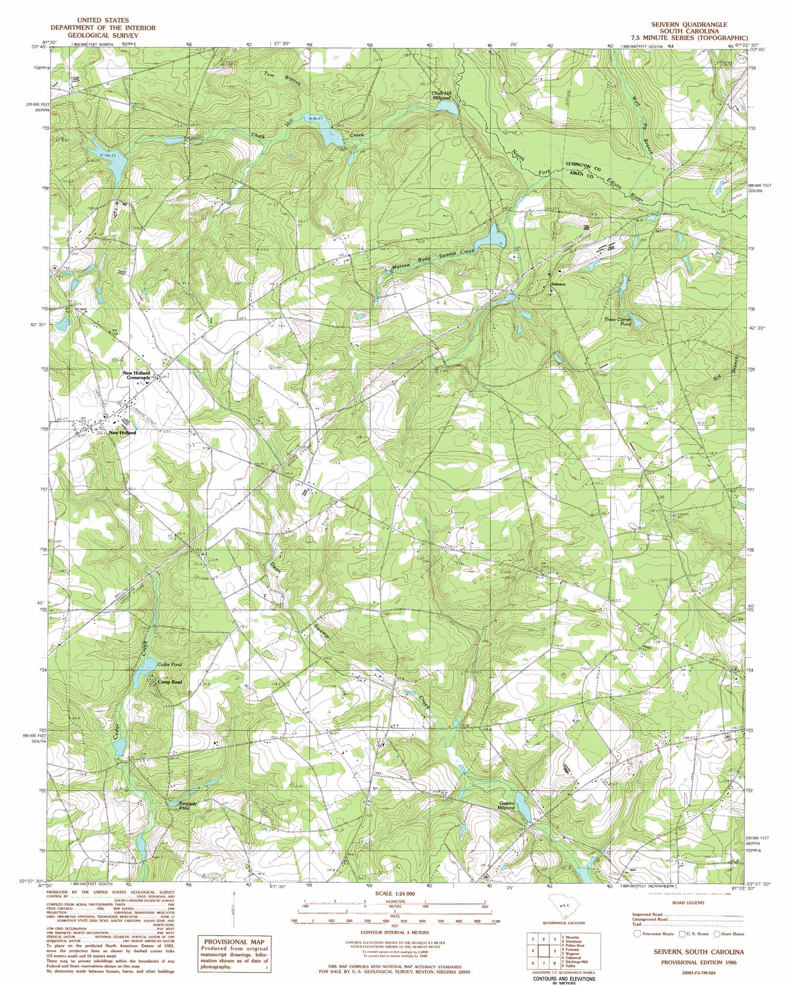
Seivern Topo Map South Carolina
To zoom in, hover over the map of Seivern
USGS Topo Quad 33081f4 - 1:24,000 scale
| Topo Map Name: | Seivern |
| USGS Topo Quad ID: | 33081f4 |
| Print Size: | ca. 21 1/4" wide x 27" high |
| Southeast Coordinates: | 33.625° N latitude / 81.375° W longitude |
| Map Center Coordinates: | 33.6875° N latitude / 81.4375° W longitude |
| U.S. State: | SC |
| Filename: | o33081f4.jpg |
| Download Map JPG Image: | Seivern topo map 1:24,000 scale |
| Map Type: | Topographic |
| Topo Series: | 7.5´ |
| Map Scale: | 1:24,000 |
| Source of Map Images: | United States Geological Survey (USGS) |
| Alternate Map Versions: |
Seivern SC 1986, updated 1986 Download PDF Buy paper map Seivern SC 2011 Download PDF Buy paper map Seivern SC 2014 Download PDF Buy paper map |
1:24,000 Topo Quads surrounding Seivern
Emory |
Batesburg |
Gilbert |
Barr Lake |
Lexington |
Ridge Spring |
Monetta |
Steedman |
Fairview Crossroads |
Pelion East |
Aiken Nw |
Foxtown |
Seivern |
Wagener |
Pond Branch |
Aiken |
Oakwood |
Kitchings Mill |
Salley |
Harleys Millpond |
New Ellenton |
Windsor |
Williston |
Springfield |
Norway West |
> Back to 33081e1 at 1:100,000 scale
> Back to 33080a1 at 1:250,000 scale
> Back to U.S. Topo Maps home
Seivern topo map: Gazetteer
Seivern: Bridges
Merritts Bridge elevation 85m 278′White Bluff Bridge (historical) elevation 89m 291′
Seivern: Dams
South Carolina Noname 02072 D-2130 Dam elevation 102m 334′South Carolina Noname 02097 D-2029 Dam elevation 101m 331′
South Carolina Noname 02098 D-2140 Dam elevation 106m 347′
South Carolina Noname 02113 D-2142 Dam elevation 95m 311′
South Carolina Noname 02114 D-2135 Dam elevation 92m 301′
South Carolina Noname 02116 D-2136 Dam elevation 98m 321′
South Carolina Noname 02123 D-2141 Dam elevation 106m 347′
South Carolina Noname 02142 D-2145 Dam elevation 135m 442′
Seivern: Lakes
Altman Pond elevation 103m 337′Cedar Pond elevation 112m 367′
Gantts Pond elevation 92m 301′
Three Corner Pond elevation 119m 390′
Seivern: Populated Places
Barefoot elevation 158m 518′Camp Rawls elevation 132m 433′
Chaffee (historical) elevation 138m 452′
New Holland elevation 162m 531′
New Holland Crossroads elevation 164m 538′
Seivern elevation 125m 410′
Seivern: Reservoirs
Bonnie Lake elevation 95m 311′Bragdens Pond elevation 117m 383′
Brogmans Pond elevation 118m 387′
Chalk Hill Millpond elevation 92m 301′
Cofer Pond elevation 110m 360′
Garvin Lower Pond elevation 106m 347′
Garvins Millpond elevation 102m 334′
Gunters Millpond elevation 110m 360′
Kennedy Pond elevation 102m 334′
Rawls Millpond elevation 108m 354′
Seivern Lake elevation 135m 442′
Swartz Pond elevation 101m 331′
Williams Pond elevation 98m 321′
Seivern: Streams
Chalk Hill Creek elevation 85m 278′Juniper Creek elevation 93m 305′
Marrow Bone Swamp Creek elevation 87m 285′
Toms Branch elevation 102m 334′
Wolf Pit Branch elevation 85m 278′
Seivern digital topo map on disk
Buy this Seivern topo map showing relief, roads, GPS coordinates and other geographical features, as a high-resolution digital map file on DVD:
South Carolina, Western North Carolina & Northeastern Georgia
Buy digital topo maps: South Carolina, Western North Carolina & Northeastern Georgia