Holly Ridge Topo Map North Carolina
To zoom in, hover over the map of Holly Ridge
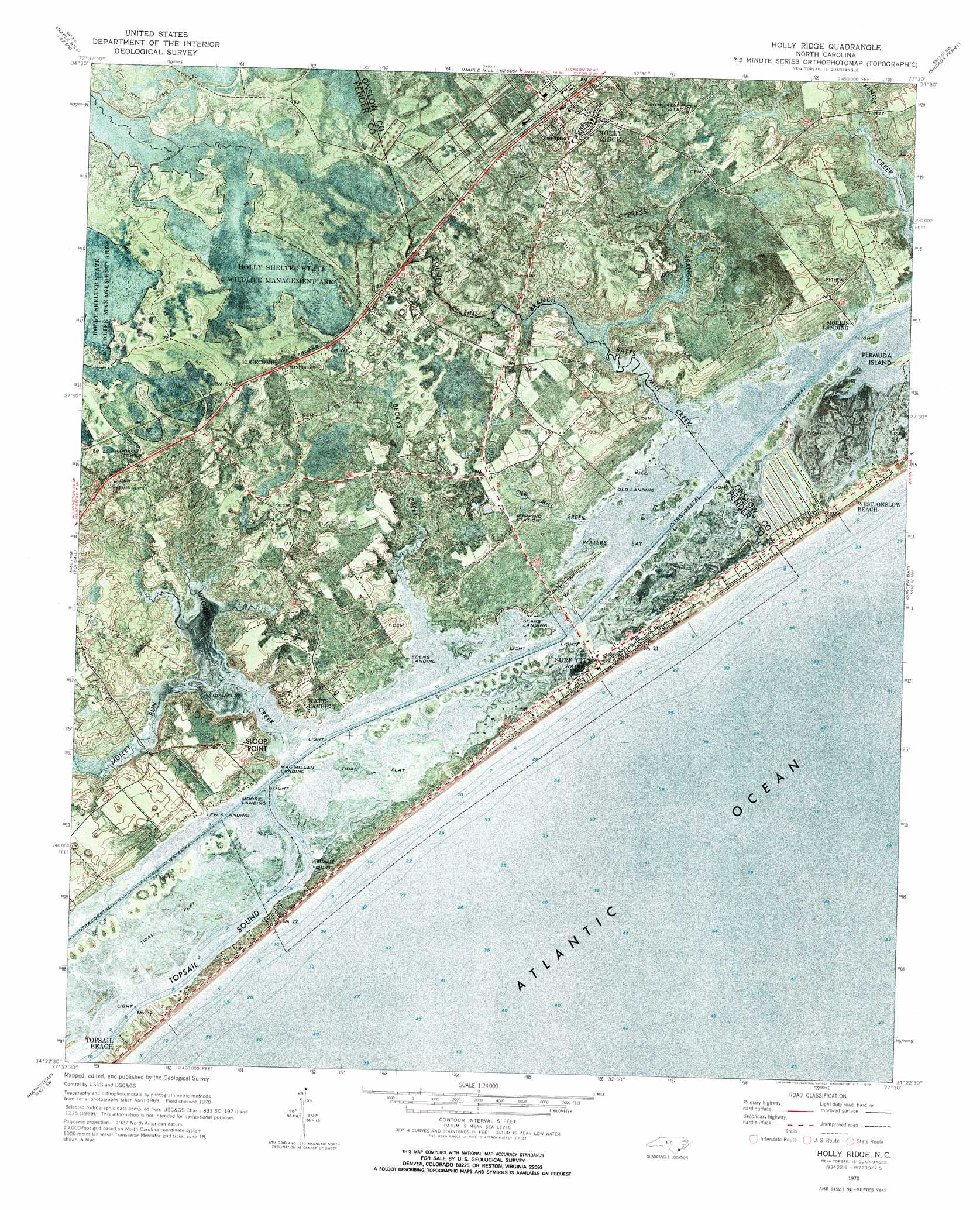
USGS Topo Quad 34077d5 - 1:24,000 scale
| Topo Map Name: | Holly Ridge |
| USGS Topo Quad ID: | 34077d5 |
| Print Size: | ca. 21 1/4" wide x 27" high |
| Southeast Coordinates: | 34.375° N latitude / 77.5° W longitude |
| Map Center Coordinates: | 34.4375° N latitude / 77.5625° W longitude |
| U.S. State: | NC |
| Filename: | p34077d5.jpg |
| Download Map JPG Image: | Holly Ridge topo map 1:24,000 scale |
| Map Type: | Orthophoto |
| Topo Series: | 7.5´ |
| Map Scale: | 1:24,000 |
| Source of Map Images: | United States Geological Survey (USGS) |
| Alternate Map Versions: |
Holly Ridge NC 1970, updated 1973 Download PDF Buy paper map Holly Ridge NC 1980, updated 1985 Download PDF Buy paper map Holly Ridge NC 1997, updated 1999 Download PDF Buy paper map Holly Ridge NC 2010 Download PDF Buy paper map Holly Ridge NC 2013 Download PDF Buy paper map Holly Ridge NC 2016 Download PDF Buy paper map |
1:24,000 Topo Quads surrounding Holly Ridge
Pin Hook |
Maple Hill |
Haws Run |
Jacksonville South |
Camp Lejeune |
Stag Park |
Maple Hill Sw |
Folkstone |
Sneads Ferry |
New River Inlet |
Mooretown |
Topsail |
Holly Ridge |
Spicer Bay |
|
Scotts Hill |
Hampstead |
|||
Wrightsville Beach |
> Back to 34077a1 at 1:100,000 scale
> Back to 34076a1 at 1:250,000 scale
> Back to U.S. Topo Maps home
Holly Ridge topo map: Gazetteer
Holly Ridge: Airports
Holly Ridge Airpark elevation 9m 29′Holly Ridge: Bays
Waters Bay elevation 0m 0′Holly Ridge: Capes
Dixon Point elevation 0m 0′Dixon Point elevation 1m 3′
Sloop Point elevation 4m 13′
Holly Ridge: Channels
Banks Channel elevation 2m 6′Holly Ridge: Dams
Yow-Williams Pond Dam elevation 1m 3′Holly Ridge: Islands
Moll Island elevation 0m 0′Holly Ridge: Populated Places
Barlowes elevation 9m 29′Edgecombe elevation 18m 59′
Holly Hills Mobile Home Estate elevation 14m 45′
Holly Ridge elevation 19m 62′
J and M Mobile Home Park elevation 9m 29′
Mill Creek Mobile Home Park elevation 9m 29′
Powells Mobile Home Park elevation 1m 3′
Sloop Point elevation 1m 3′
Surf City elevation 1m 3′
Watts Landing elevation 10m 32′
West Onslow Beach elevation 2m 6′
Holly Ridge: Post Offices
Sloop Point Post Office elevation 9m 29′Holly Ridge: Reservoirs
Yow-Williams Pond elevation 1m 3′Holly Ridge: Streams
Batts Mill Creek elevation 0m 0′Beckys Creek elevation 0m 0′
County Line Branch elevation 1m 3′
Cypress Branch elevation 0m 0′
Mullet Run elevation 0m 0′
Old Mill Creek elevation 0m 0′
Virginia Creek elevation 0m 0′
Holly Ridge digital topo map on disk
Buy this Holly Ridge topo map showing relief, roads, GPS coordinates and other geographical features, as a high-resolution digital map file on DVD:
Atlantic Coast (NY, NJ, PA, DE, MD, VA, NC)
Buy digital topo maps: Atlantic Coast (NY, NJ, PA, DE, MD, VA, NC)
 map DVD")