Unap Mountain Topo Map Oklahoma
To zoom in, hover over the map of Unap Mountain
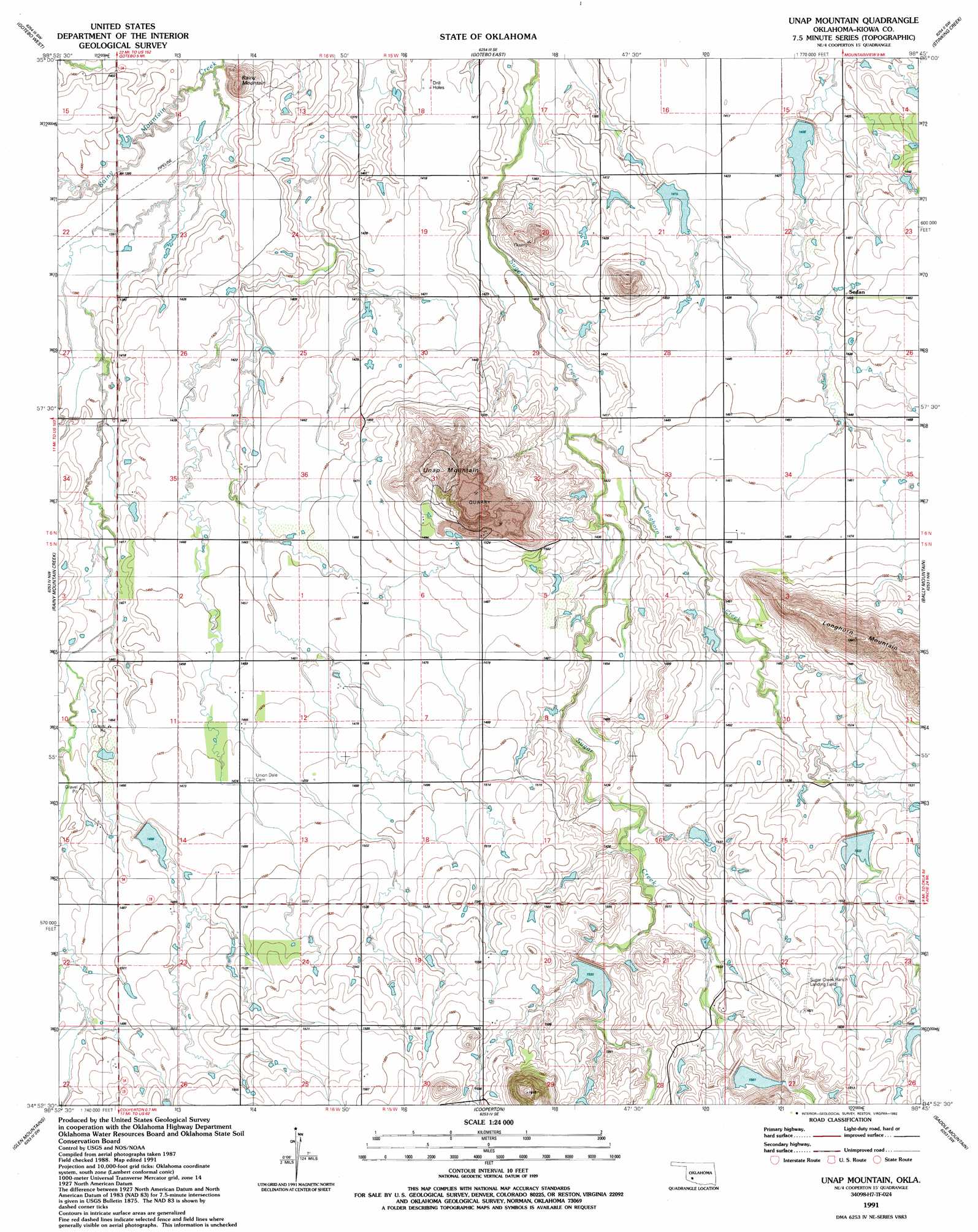
USGS Topo Quad 34098h7 - 1:24,000 scale
| Topo Map Name: | Unap Mountain |
| USGS Topo Quad ID: | 34098h7 |
| Print Size: | ca. 21 1/4" wide x 27" high |
| Southeast Coordinates: | 34.875° N latitude / 98.75° W longitude |
| Map Center Coordinates: | 34.9375° N latitude / 98.8125° W longitude |
| U.S. State: | OK |
| Filename: | o34098h7.jpg |
| Download Map JPG Image: | Unap Mountain topo map 1:24,000 scale |
| Map Type: | Topographic |
| Topo Series: | 7.5´ |
| Map Scale: | 1:24,000 |
| Source of Map Images: | United States Geological Survey (USGS) |
| Alternate Map Versions: |
Unap Mountain OK 1956, updated 1959 Download PDF Buy paper map Unap Mountain OK 1956, updated 1976 Download PDF Buy paper map Unap Mountain OK 1991, updated 1992 Download PDF Buy paper map Unap Mountain OK 2010 Download PDF Buy paper map Unap Mountain OK 2012 Download PDF Buy paper map Unap Mountain OK 2016 Download PDF Buy paper map |
1:24,000 Topo Quads surrounding Unap Mountain
Rocky |
Gotebo Nw |
Lake Valley |
Cowden |
Alfalfa |
Hobart |
Gotebo West |
Gotebo East |
Stinking Creek |
Carnegie |
Babbs |
Rainy Mountain Creek |
Unap Mountain |
Bally Mountain |
Alden |
Roosevelt |
Glen Mountains |
Cooperton |
Saddle Mountain |
Meers |
Long Mountain |
Snyder |
Odetta |
Quanah Mountain |
Mount Scott |
> Back to 34098e1 at 1:100,000 scale
> Back to 34098a1 at 1:250,000 scale
> Back to U.S. Topo Maps home
Unap Mountain topo map: Gazetteer
Unap Mountain: Airports
Jennings Ranch Airport elevation 489m 1604′Sugar Creek Ranch Airport elevation 488m 1601′
Unap Mountain: Dams
Oknoname 075018 Dam elevation 451m 1479′Rainy Mountain Creek Site 10 Dam elevation 476m 1561′
Rainy Mountain Creek Site 11 Dam elevation 458m 1502′
Rainy Mountain Creek Site 13 Dam elevation 443m 1453′
Rainy Mountain Creek Site 4 Dam elevation 428m 1404′
Rainy Mountain Creek Site 6 Dam elevation 426m 1397′
Rainy Mountain Creek Site 8a Dam elevation 449m 1473′
Rainy Mountain Creek Site 9 Dam elevation 467m 1532′
Unap Mountain: Populated Places
Sedan elevation 445m 1459′Unap Mountain: Reservoirs
Oknoname 075018 Reservoir elevation 451m 1479′Rainy Mountain Creek Site 10 Reservoir elevation 476m 1561′
Rainy Mountain Creek Site 11 Reservoir elevation 458m 1502′
Rainy Mountain Creek Site 13 Reservoir elevation 443m 1453′
Rainy Mountain Creek Site 4 Reservoir elevation 428m 1404′
Rainy Mountain Creek Site 6 Reservoir elevation 426m 1397′
Rainy Mountain Creek Site 8a Reservoir elevation 449m 1473′
Rainy Mountain Creek Site 9 Reservoir elevation 467m 1532′
Unap Mountain: Streams
Longhorn Creek elevation 429m 1407′Unap Mountain: Summits
Rainy Mountain elevation 470m 1541′Unap Mountain elevation 499m 1637′
Unap Mountain digital topo map on disk
Buy this Unap Mountain topo map showing relief, roads, GPS coordinates and other geographical features, as a high-resolution digital map file on DVD: