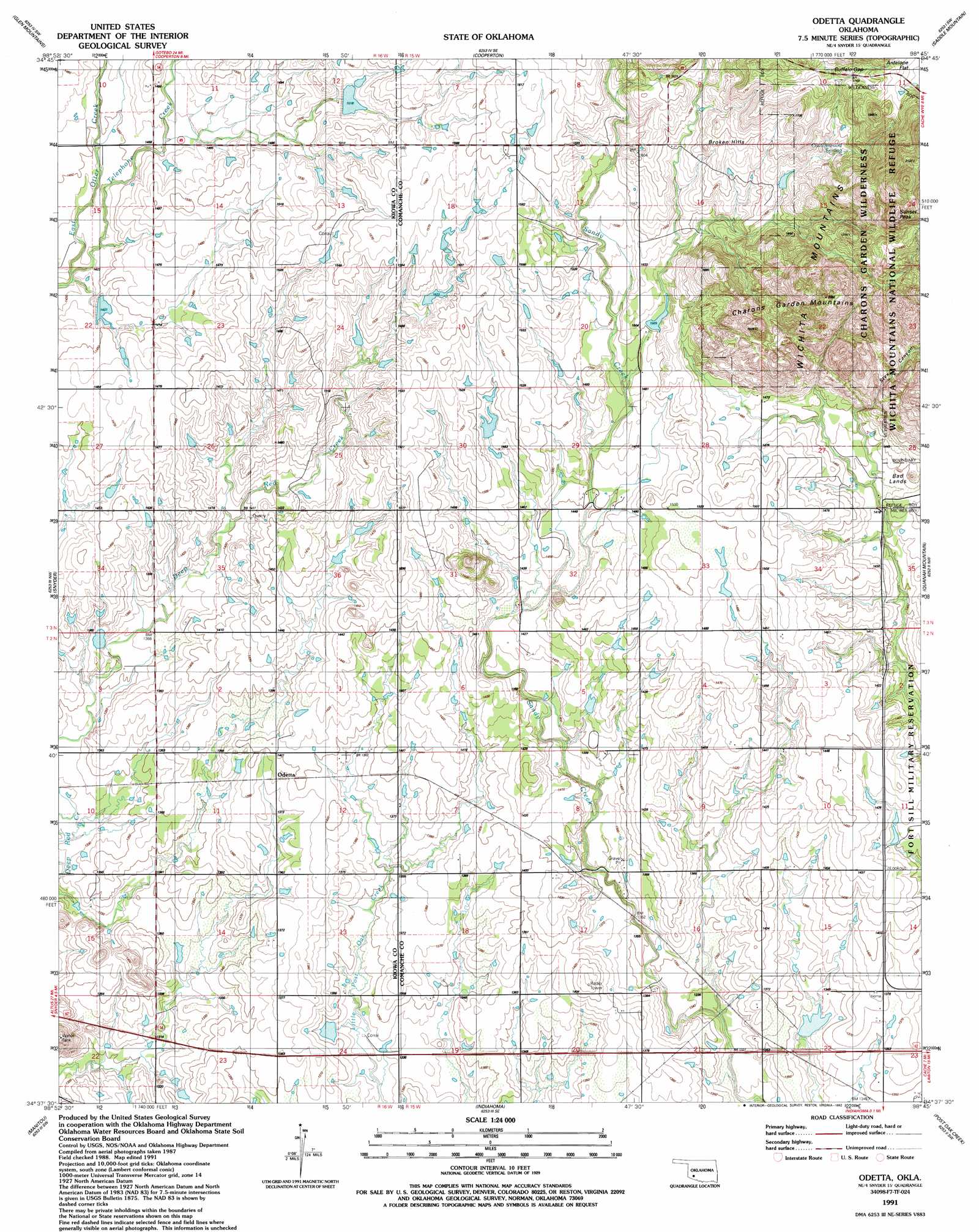
Odetta Topo Map Oklahoma
To zoom in, hover over the map of Odetta
USGS Topo Quad 34098f7 - 1:24,000 scale
| Topo Map Name: | Odetta |
| USGS Topo Quad ID: | 34098f7 |
| Print Size: | ca. 21 1/4" wide x 27" high |
| Southeast Coordinates: | 34.625° N latitude / 98.75° W longitude |
| Map Center Coordinates: | 34.6875° N latitude / 98.8125° W longitude |
| U.S. State: | OK |
| Filename: | o34098f7.jpg |
| Download Map JPG Image: | Odetta topo map 1:24,000 scale |
| Map Type: | Topographic |
| Topo Series: | 7.5´ |
| Map Scale: | 1:24,000 |
| Source of Map Images: | United States Geological Survey (USGS) |
| Alternate Map Versions: |
Odetta OK 1956, updated 1974 Download PDF Buy paper map Odetta OK 1956, updated 1976 Download PDF Buy paper map Odetta OK 1991, updated 1992 Download PDF Buy paper map Odetta OK 2010 Download PDF Buy paper map Odetta OK 2012 Download PDF Buy paper map Odetta OK 2016 Download PDF Buy paper map |
1:24,000 Topo Quads surrounding Odetta
Babbs |
Rainy Mountain Creek |
Unap Mountain |
Bally Mountain |
Alden |
Roosevelt |
Glen Mountains |
Cooperton |
Saddle Mountain |
Meers |
Long Mountain |
Snyder |
Odetta |
Quanah Mountain |
Mount Scott |
Tipton Se |
Manitou |
Indiahoma |
Post Oak Creek |
Taupa |
Frederick |
Hollister Nw |
Hollister Ne |
Chattanooga |
Faxon |
> Back to 34098e1 at 1:100,000 scale
> Back to 34098a1 at 1:250,000 scale
> Back to U.S. Topo Maps home
Odetta topo map: Gazetteer
Odetta: Dams
Oknoname 031017 Dam elevation 406m 1332′Oknoname 031065 Dam elevation 452m 1482′
Oknoname 075009 Dam elevation 437m 1433′
Oknoname 075010 Dam elevation 473m 1551′
Oknoname 075014 Dam elevation 402m 1318′
Otter Creek Site 5 Dam elevation 457m 1499′
Otter Creek Site 6 Dam elevation 437m 1433′
Odetta: Gaps
Buffalo Gap elevation 546m 1791′Odetta: Populated Places
Odetta elevation 424m 1391′Odetta: Ranges
Broken Hills elevation 497m 1630′Charons Garden Mountains elevation 484m 1587′
Odetta: Reservoirs
Oknoname 031017 Reservoir elevation 406m 1332′Oknoname 031065 Reservoir elevation 452m 1482′
Oknoname 075009 Reservoir elevation 437m 1433′
Oknoname 075010 Reservoir elevation 473m 1551′
Oknoname 075014 Reservoir elevation 402m 1318′
Otter Creek Site 5 Reservoir elevation 457m 1499′
Otter Creek Site 6 Reservoir elevation 437m 1433′
Odetta: Springs
Cottonwood Spring elevation 515m 1689′Odetta: Streams
Telephone Creek elevation 432m 1417′Odetta: Summits
Bad Lands elevation 451m 1479′Sunset Peak elevation 661m 2168′
Odetta: Valleys
Styx Canyon elevation 445m 1459′Odetta digital topo map on disk
Buy this Odetta topo map showing relief, roads, GPS coordinates and other geographical features, as a high-resolution digital map file on DVD: