Olive Branch Topo Map North Carolina
To zoom in, hover over the map of Olive Branch
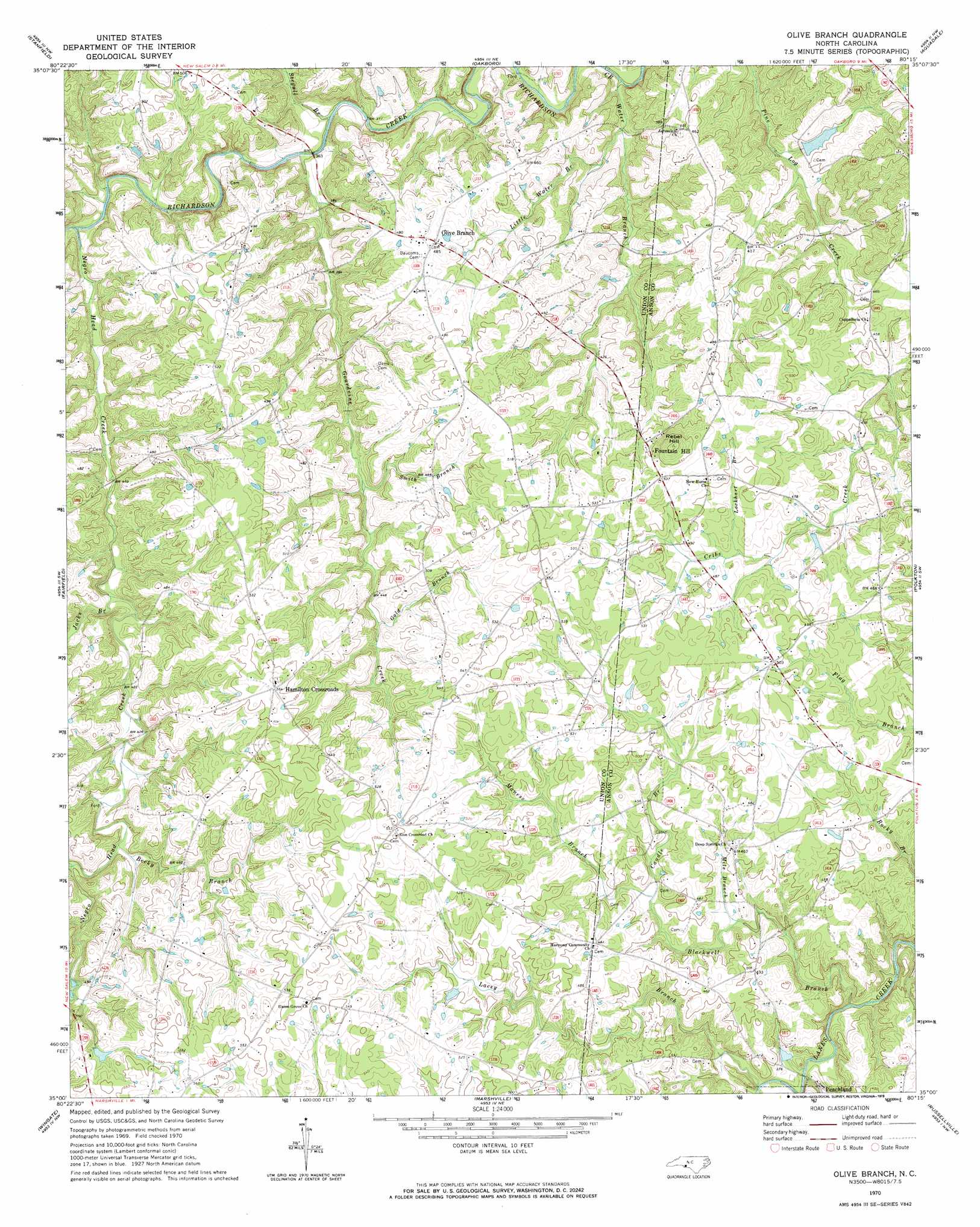
USGS Topo Quad 35080a3 - 1:24,000 scale
| Topo Map Name: | Olive Branch |
| USGS Topo Quad ID: | 35080a3 |
| Print Size: | ca. 21 1/4" wide x 27" high |
| Southeast Coordinates: | 35° N latitude / 80.25° W longitude |
| Map Center Coordinates: | 35.0625° N latitude / 80.3125° W longitude |
| U.S. State: | NC |
| Filename: | o35080a3.jpg |
| Download Map JPG Image: | Olive Branch topo map 1:24,000 scale |
| Map Type: | Topographic |
| Topo Series: | 7.5´ |
| Map Scale: | 1:24,000 |
| Source of Map Images: | United States Geological Survey (USGS) |
| Alternate Map Versions: |
Olive Branch NC 1970, updated 1973 Download PDF Buy paper map Olive Branch NC 2010 Download PDF Buy paper map Olive Branch NC 2013 Download PDF Buy paper map Olive Branch NC 2016 Download PDF Buy paper map |
1:24,000 Topo Quads surrounding Olive Branch
Concord Se |
Locust |
Frog Pond |
Albemarle |
Morrow Mountain |
Midland |
Stanfield |
Oakboro |
Aquadale |
Mount Gilead West |
Bakers |
Watson |
Olive Branch |
Polkton |
Ansonville |
Monroe |
Wingate |
Marshville |
Russellville |
Wadesboro |
Tradesville |
Pageland |
Hornsboro |
Mount Croghan |
Morven West |
> Back to 35080a1 at 1:100,000 scale
> Back to 35080a1 at 1:250,000 scale
> Back to U.S. Topo Maps home
Olive Branch topo map: Gazetteer
Olive Branch: Dams
Jones Pond Dam elevation 121m 396′Olive Branch: Populated Places
Fountain Hill elevation 152m 498′Hamilton Crossroads elevation 170m 557′
Olive Branch elevation 147m 482′
Olive Branch: Reservoirs
Jones Pond elevation 121m 396′Olive Branch: Streams
Becky Branch elevation 132m 433′Blackwell Branch elevation 109m 357′
Caudle Branch elevation 128m 419′
Gold Branch elevation 136m 446′
Gourdvine Creek elevation 108m 354′
Jacks Branch elevation 123m 403′
Lacey Branch elevation 109m 357′
Little Water Branch elevation 96m 314′
Lockhart Branch elevation 139m 456′
Maness Branch elevation 128m 419′
Mile Branch elevation 123m 403′
Salem Creek elevation 114m 374′
Smith Branch elevation 126m 413′
Stegall Branch elevation 106m 347′
Water Branch elevation 91m 298′
Olive Branch: Summits
Rebel Hill elevation 186m 610′Olive Branch digital topo map on disk
Buy this Olive Branch topo map showing relief, roads, GPS coordinates and other geographical features, as a high-resolution digital map file on DVD:
South Carolina, Western North Carolina & Northeastern Georgia
Buy digital topo maps: South Carolina, Western North Carolina & Northeastern Georgia