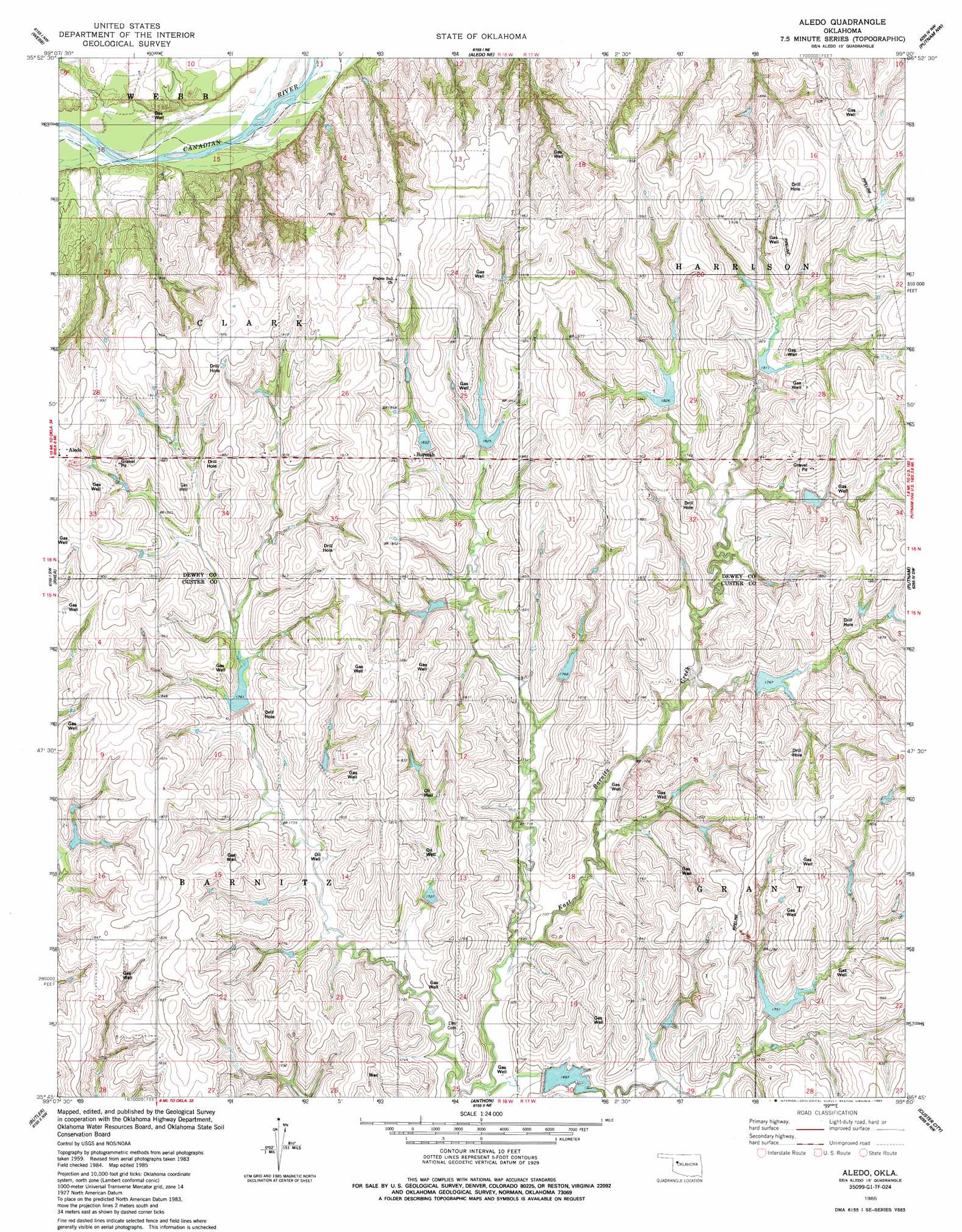
Aledo Topo Map Oklahoma
To zoom in, hover over the map of Aledo
USGS Topo Quad 35099g1 - 1:24,000 scale
| Topo Map Name: | Aledo |
| USGS Topo Quad ID: | 35099g1 |
| Print Size: | ca. 21 1/4" wide x 27" high |
| Southeast Coordinates: | 35.75° N latitude / 99° W longitude |
| Map Center Coordinates: | 35.8125° N latitude / 99.0625° W longitude |
| U.S. State: | OK |
| Filename: | o35099g1.jpg |
| Download Map JPG Image: | Aledo topo map 1:24,000 scale |
| Map Type: | Topographic |
| Topo Series: | 7.5´ |
| Map Scale: | 1:24,000 |
| Source of Map Images: | United States Geological Survey (USGS) |
| Alternate Map Versions: |
Aledo OK 1985, updated 1985 Download PDF Buy paper map Aledo OK 2010 Download PDF Buy paper map Aledo OK 2012 Download PDF Buy paper map Aledo OK 2016 Download PDF Buy paper map |
1:24,000 Topo Quads surrounding Aledo
Camargo |
Mutual Sw |
Lenora |
Taloga |
Hucmac |
Trail |
Webb |
Aledo Nw |
Putnam Nw |
Parallel |
Leedey |
Rhea |
Aledo |
Putnam |
Rough Creek |
Mcclure |
Butler |
Anthon |
Custer City |
Clinton Ne |
Carpenter |
Foss Dam |
Stafford |
Clinton |
Indianapolis |
> Back to 35099e1 at 1:100,000 scale
> Back to 35098a1 at 1:250,000 scale
> Back to U.S. Topo Maps home
Aledo topo map: Gazetteer
Aledo: Dams
Barnitz Creek Site 105 Dam elevation 547m 1794′Barnitz Creek Site 11 Dam elevation 559m 1833′
Barnitz Creek Site 12 Dam elevation 557m 1827′
Barnitz Creek Site 13 Dam elevation 556m 1824′
Barnitz Creek Site 14 Dam elevation 558m 1830′
Barnitz Creek Site 15 Dam elevation 548m 1797′
Barnitz Creek Site 17 Dam elevation 539m 1768′
Barnitz Creek Site 18 Dam elevation 538m 1765′
Barnitz Creek Site 23 Dam elevation 548m 1797′
Barnitz Creek Site 24 Dam elevation 542m 1778′
Barnitz Creek Site 25 Dam elevation 531m 1742′
Barnitz Creek Site 27 Dam elevation 546m 1791′
Barnitz Creek Site 28 Dam elevation 537m 1761′
Barnitz Creek Site 30 Dam elevation 522m 1712′
Barnitz Creek Site 31 Dam elevation 534m 1751′
Roy Higgins Dam elevation 544m 1784′
Aledo: Populated Places
Aledo elevation 589m 1932′Burmah elevation 567m 1860′
Aledo: Reservoirs
Barnitz Creek Site 105 Reservoir elevation 547m 1794′Barnitz Creek Site 11 Reservoir elevation 559m 1833′
Barnitz Creek Site 12 Reservoir elevation 557m 1827′
Barnitz Creek Site 13 Reservoir elevation 556m 1824′
Barnitz Creek Site 14 Reservoir elevation 558m 1830′
Barnitz Creek Site 15 Reservoir elevation 548m 1797′
Barnitz Creek Site 17 Reservoir elevation 539m 1768′
Barnitz Creek Site 18 Reservoir elevation 538m 1765′
Barnitz Creek Site 23 Reservoir elevation 548m 1797′
Barnitz Creek Site 24 Reservoir elevation 542m 1778′
Barnitz Creek Site 25 Reservoir elevation 531m 1742′
Barnitz Creek Site 27 Reservoir elevation 546m 1791′
Barnitz Creek Site 28 Reservoir elevation 537m 1761′
Barnitz Creek Site 30 Reservoir elevation 522m 1712′
Barnitz Creek Site 31 Reservoir elevation 534m 1751′
Roy Higgins Reservoir elevation 544m 1784′
Aledo digital topo map on disk
Buy this Aledo topo map showing relief, roads, GPS coordinates and other geographical features, as a high-resolution digital map file on DVD: