Anthon Topo Map Oklahoma
To zoom in, hover over the map of Anthon
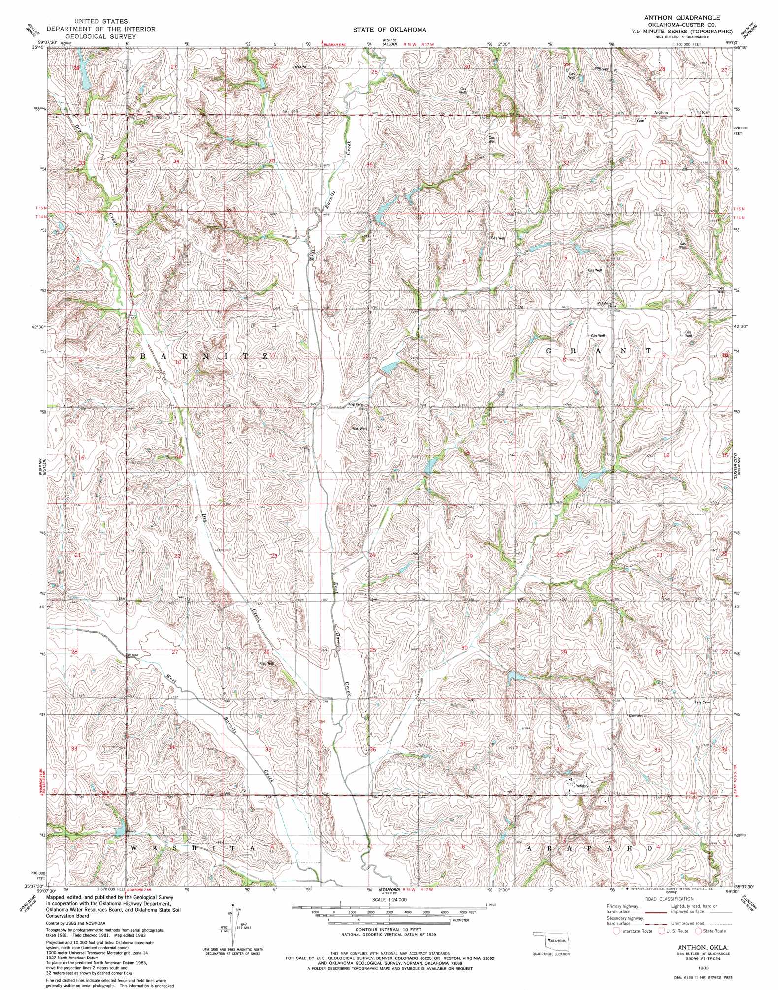
USGS Topo Quad 35099f1 - 1:24,000 scale
| Topo Map Name: | Anthon |
| USGS Topo Quad ID: | 35099f1 |
| Print Size: | ca. 21 1/4" wide x 27" high |
| Southeast Coordinates: | 35.625° N latitude / 99° W longitude |
| Map Center Coordinates: | 35.6875° N latitude / 99.0625° W longitude |
| U.S. State: | OK |
| Filename: | o35099f1.jpg |
| Download Map JPG Image: | Anthon topo map 1:24,000 scale |
| Map Type: | Topographic |
| Topo Series: | 7.5´ |
| Map Scale: | 1:24,000 |
| Source of Map Images: | United States Geological Survey (USGS) |
| Alternate Map Versions: |
Anthon OK 1983, updated 1984 Download PDF Buy paper map Anthon OK 2010 Download PDF Buy paper map Anthon OK 2012 Download PDF Buy paper map Anthon OK 2016 Download PDF Buy paper map |
1:24,000 Topo Quads surrounding Anthon
Trail |
Webb |
Aledo Nw |
Putnam Nw |
Parallel |
Leedey |
Rhea |
Aledo |
Putnam |
Rough Creek |
Mcclure |
Butler |
Anthon |
Custer City |
Clinton Ne |
Carpenter |
Foss Dam |
Stafford |
Clinton |
Indianapolis |
Canute |
Foss |
Dill City Ne |
Bessie |
Corn |
> Back to 35099e1 at 1:100,000 scale
> Back to 35098a1 at 1:250,000 scale
> Back to U.S. Topo Maps home
Anthon topo map: Gazetteer
Anthon: Dams
Barnitz Creek Site 21 Dam elevation 525m 1722′Barnitz Creek Site 22 Dam elevation 523m 1715′
Barnitz Creek Site 29 Dam elevation 521m 1709′
Barnitz Creek Site 32 Dam elevation 515m 1689′
Barnitz Creek Site 33 Dam elevation 515m 1689′
Barnitz Creek Site 34 Dam elevation 505m 1656′
Barnitz Creek Site 52 Dam elevation 513m 1683′
Barnitz Creek Site 56 Dam elevation 496m 1627′
Barnitz Creek Site 65 Dam elevation 536m 1758′
Barnitz Creek Site 68 Dam elevation 524m 1719′
Barnitz Creek Site 70 Dam elevation 511m 1676′
Anthon: Populated Places
Anthon elevation 562m 1843′Anthon: Reservoirs
Barnitz Creek Site 21 Reservoir elevation 525m 1722′Barnitz Creek Site 22 Reservoir elevation 523m 1715′
Barnitz Creek Site 29 Reservoir elevation 521m 1709′
Barnitz Creek Site 32 Reservoir elevation 515m 1689′
Barnitz Creek Site 33 Reservoir elevation 515m 1689′
Barnitz Creek Site 34 Reservoir elevation 505m 1656′
Barnitz Creek Site 52 Reservoir elevation 513m 1683′
Barnitz Creek Site 56 Reservoir elevation 496m 1627′
Barnitz Creek Site 65 Reservoir elevation 536m 1758′
Barnitz Creek Site 68 Reservoir elevation 524m 1719′
Barnitz Creek Site 70 Reservoir elevation 511m 1676′
Anthon: Streams
Dry Creek elevation 485m 1591′Anthon digital topo map on disk
Buy this Anthon topo map showing relief, roads, GPS coordinates and other geographical features, as a high-resolution digital map file on DVD: