Sun Altar Topo Map Arizona
To zoom in, hover over the map of Sun Altar
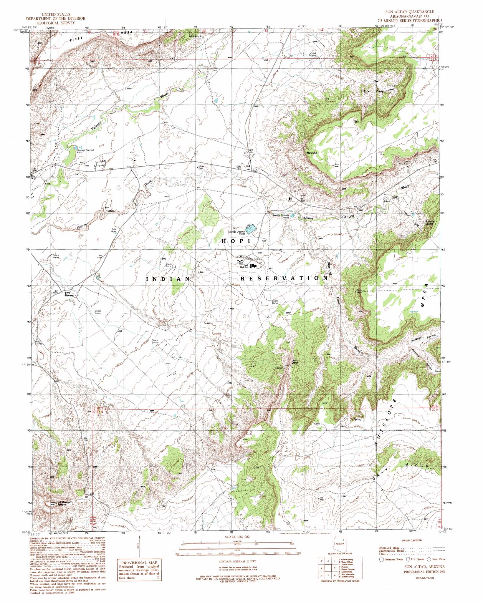
USGS Topo Quad 35110g3 - 1:24,000 scale
| Topo Map Name: | Sun Altar |
| USGS Topo Quad ID: | 35110g3 |
| Print Size: | ca. 21 1/4" wide x 27" high |
| Southeast Coordinates: | 35.75° N latitude / 110.25° W longitude |
| Map Center Coordinates: | 35.8125° N latitude / 110.3125° W longitude |
| U.S. State: | AZ |
| Filename: | o35110g3.jpg |
| Download Map JPG Image: | Sun Altar topo map 1:24,000 scale |
| Map Type: | Topographic |
| Topo Series: | 7.5´ |
| Map Scale: | 1:24,000 |
| Source of Map Images: | United States Geological Survey (USGS) |
| Alternate Map Versions: |
Sun Altar AZ 1991, updated 1991 Download PDF Buy paper map Sun Altar AZ 2011 Download PDF Buy paper map Sun Altar AZ 2014 Download PDF Buy paper map |
1:24,000 Topo Quads surrounding Sun Altar
Rocky Ridge Se |
Hard Rocks |
Little Black Spot Mountain |
Pinon |
Whippoorwill Spring |
Oraibi |
Onion Spring |
Wepo Village |
Echo Canyon |
Low Mountain |
Shongopovi |
Polacca |
Sun Altar |
Keams Canyon |
Lamb Well |
Giants Chair |
Snake Butte |
Star Mountain |
Jadito Spring |
Tsin Naan Tee |
Tovar Mesa East |
Egloffstein Butte |
Hauke Mesa |
First Flat Mesa |
White Cone |
> Back to 35110e1 at 1:100,000 scale
> Back to 35110a1 at 1:250,000 scale
> Back to U.S. Topo Maps home
Sun Altar topo map: Gazetteer
Sun Altar: Benches
Windswept Terrace elevation 1847m 6059′Sun Altar: Cliffs
Mots'ovi elevation 1926m 6318′Sun Altar: Ridges
Five Houses Butte elevation 1837m 6026′Gray Ridge elevation 2014m 6607′
Sun Altar: Springs
Sactone Spring elevation 1833m 6013′Wingva elevation 1776m 5826′
Sun Altar: Streams
Bluebird Canyon Wash elevation 1773m 5816′Sun Altar: Summits
Sun Altar elevation 1931m 6335′Sun Altar: Valleys
Bluebird Canyon elevation 1861m 6105′Owl Box Canyon elevation 1802m 5912′
Snowbird Canyon elevation 1852m 6076′
Sun Altar digital topo map on disk
Buy this Sun Altar topo map showing relief, roads, GPS coordinates and other geographical features, as a high-resolution digital map file on DVD: