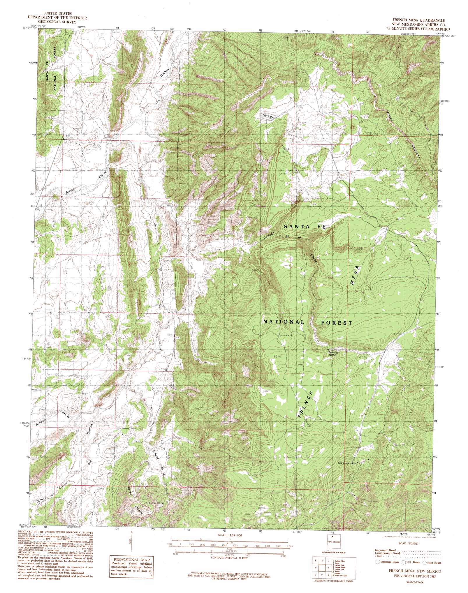
French Mesa Topo Map New Mexico
To zoom in, hover over the map of French Mesa
USGS Topo Quad 36106c7 - 1:24,000 scale
| Topo Map Name: | French Mesa |
| USGS Topo Quad ID: | 36106c7 |
| Print Size: | ca. 21 1/4" wide x 27" high |
| Southeast Coordinates: | 36.25° N latitude / 106.75° W longitude |
| Map Center Coordinates: | 36.3125° N latitude / 106.8125° W longitude |
| U.S. State: | NM |
| Filename: | o36106c7.jpg |
| Download Map JPG Image: | French Mesa topo map 1:24,000 scale |
| Map Type: | Topographic |
| Topo Series: | 7.5´ |
| Map Scale: | 1:24,000 |
| Source of Map Images: | United States Geological Survey (USGS) |
| Alternate Map Versions: |
French Mesa NM 1983, updated 1983 Download PDF Buy paper map French Mesa NM 2002, updated 2003 Download PDF Buy paper map French Mesa NM 2011 Download PDF Buy paper map French Mesa NM 2013 Download PDF Buy paper map |
| FStopo: | US Forest Service topo French Mesa is available: Download FStopo PDF Download FStopo TIF |
1:24,000 Topo Quads surrounding French Mesa
Leavry Canyon |
Los Indios Canyon |
Pounds Mesa |
El Vado |
Las Nutrias |
Ojito |
Canada Ojitos |
Llaves |
Navajo Peak |
Alire |
Lindrith |
Laguna Gurule |
French Mesa |
Laguna Peak |
Echo Amphitheater |
Five Lakes Canyon Ne |
Regina |
Gallina |
Arroyo Del Agua |
Youngsville |
Arroyo Chijuillita |
Cuba |
Nacimiento Peak |
Jarosa |
Cerro Del Grant |
> Back to 36106a1 at 1:100,000 scale
> Back to 36106a1 at 1:250,000 scale
> Back to U.S. Topo Maps home
French Mesa topo map: Gazetteer
French Mesa: Arroyos
Canada de la Cueva elevation 2197m 7208′French Mesa: Cliffs
Rincon Colorado elevation 2492m 8175′French Mesa: Lakes
Dry Lake elevation 2333m 7654′French Mesa: Populated Places
Llaves elevation 2156m 7073′French Mesa: Post Offices
Llaves Post Office elevation 2165m 7103′French Mesa: Reservoirs
Boundary Tank elevation 2458m 8064′Cher Tank elevation 2188m 7178′
Dan Tank elevation 2126m 6975′
Ferran Tank elevation 2426m 7959′
Guadalupita Tank elevation 2395m 7857′
Jim Tank elevation 2164m 7099′
Junior Tank elevation 2489m 8166′
La Cueva Tank elevation 2467m 8093′
La Jara Tank elevation 2507m 8225′
Llaves Tank elevation 2158m 7080′
Prospect Tank elevation 2345m 7693′
Rincon Tank elevation 2328m 7637′
Steve Tank elevation 2164m 7099′
Tom Tank elevation 2211m 7253′
Tonya Tank elevation 2122m 6961′
Wendy Tank elevation 2153m 7063′
French Mesa: Springs
Leandro Spring elevation 2483m 8146′Ojo la Jara elevation 2481m 8139′
French Mesa: Summits
Cerro Blanco elevation 2468m 8097′French Mesa elevation 2638m 8654′
French Mesa: Valleys
Almagre Arroyo elevation 2173m 7129′Arroyo Blanco elevation 2108m 6916′
Cañada de la Cueva elevation 2138m 7014′
Cañada de la Tableta elevation 2170m 7119′
Cañon de Chavez elevation 2183m 7162′
French Mesa digital topo map on disk
Buy this French Mesa topo map showing relief, roads, GPS coordinates and other geographical features, as a high-resolution digital map file on DVD: