Mummy Cave Ruins Topo Map Arizona
To zoom in, hover over the map of Mummy Cave Ruins
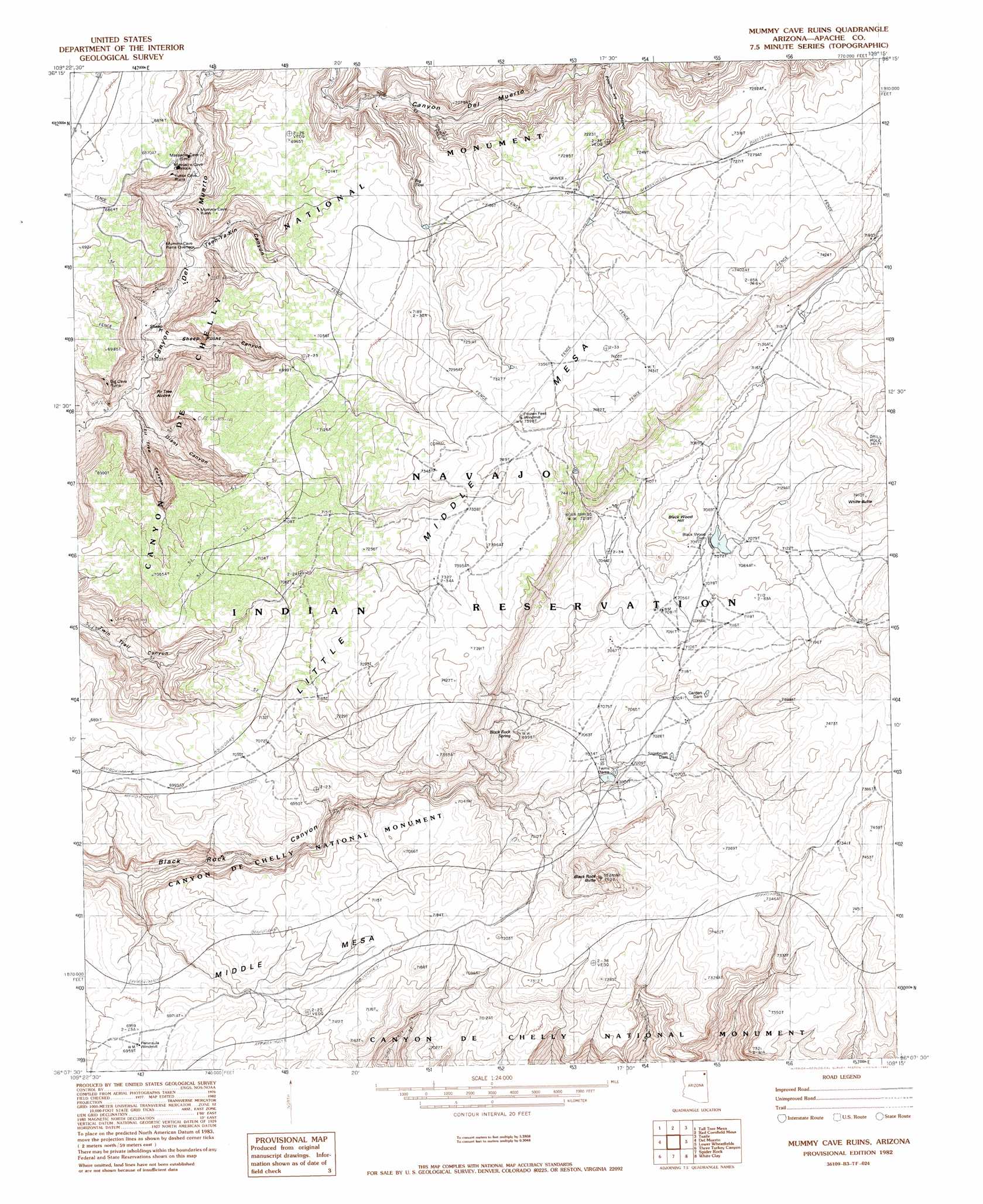
USGS Topo Quad 36109b3 - 1:24,000 scale
| Topo Map Name: | Mummy Cave Ruins |
| USGS Topo Quad ID: | 36109b3 |
| Print Size: | ca. 21 1/4" wide x 27" high |
| Southeast Coordinates: | 36.125° N latitude / 109.25° W longitude |
| Map Center Coordinates: | 36.1875° N latitude / 109.3125° W longitude |
| U.S. State: | AZ |
| Filename: | o36109b3.jpg |
| Download Map JPG Image: | Mummy Cave Ruins topo map 1:24,000 scale |
| Map Type: | Topographic |
| Topo Series: | 7.5´ |
| Map Scale: | 1:24,000 |
| Source of Map Images: | United States Geological Survey (USGS) |
| Alternate Map Versions: |
Sonsala Butte 3 NE AZ 1955, updated 1958 Download PDF Buy paper map Mummy Cave Ruins AZ 1982, updated 1982 Download PDF Buy paper map Black Rock Butte AZ 2011 Download PDF Buy paper map Black Rock Butte AZ 2014 Download PDF Buy paper map |
1:24,000 Topo Quads surrounding Mummy Cave Ruins
Many Farms Ne |
Fire Dance Mesa |
Bad Bug Butte |
Lukachukai |
Roof Butte |
Many Farms |
Tall Tree Mesa |
Red Cornfield Mesa |
Tsaile |
Tsaile Butte |
Chinle |
Del Merto |
Mummy Cave Ruins |
Lower Wheatfields |
Upper Wheatfields |
Little White House Ruins |
Three Turkey Canyon |
Spider Rock |
White Clay |
Sonsela Buttes |
Beautiful Valley Well |
Nazlini |
White Rock Wash |
Sawmill |
Buell Park |
> Back to 36109a1 at 1:100,000 scale
> Back to 36108a1 at 1:250,000 scale
> Back to U.S. Topo Maps home
Mummy Cave Ruins topo map: Gazetteer
Mummy Cave Ruins: Areas
Ndishchii Naati elevation 2167m 7109′Mummy Cave Ruins: Cliffs
Sheep Point elevation 0m 0′Mummy Cave Ruins: Dams
Garden Dam elevation 2156m 7073′Sagebrush Dam elevation 2148m 7047′
Twin Dams elevation 2129m 6984′
Mummy Cave Ruins: Falls
Big Flow elevation 2105m 6906′Mummy Cave Ruins: Springs
Bear Spring elevation 2191m 7188′Black Rock Spring elevation 2108m 6916′
Mummy Cave Ruins: Summits
Ata Deeza elevation 2301m 7549′Black Rock Butte elevation 2207m 7240′
Black Wood Hill elevation 2173m 7129′
Little Middle Mesa elevation 2264m 7427′
Middle Mesa elevation 2197m 7208′
White Butte elevation 2261m 7417′
Mummy Cave Ruins: Trails
Black Rock Trail elevation 1907m 6256′Red Clay Trail elevation 2233m 7326′
Spanish Trail elevation 2153m 7063′
Mummy Cave Ruins: Valleys
Fir Tree Canyon elevation 1836m 6023′Giant Canyon elevation 1822m 5977′
Poison Ivy Canyon elevation 1969m 6459′
Sheep Point Canyon elevation 0m 0′
Tseh-Ya-Kin Canyon elevation 1841m 6040′
Mummy Cave Ruins: Wells
Frozen Feet Windmill elevation 2254m 7395′Peninsula Windmill elevation 2120m 6955′
Mummy Cave Ruins digital topo map on disk
Buy this Mummy Cave Ruins topo map showing relief, roads, GPS coordinates and other geographical features, as a high-resolution digital map file on DVD: