Moores Station Topo Map Nevada
To zoom in, hover over the map of Moores Station
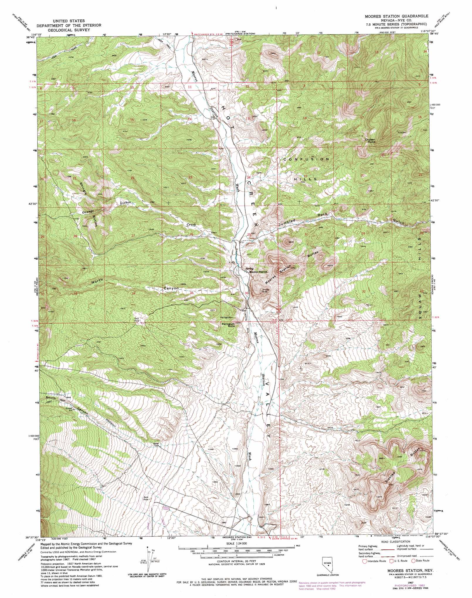
USGS Topo Quad 38116f2 - 1:24,000 scale
| Topo Map Name: | Moores Station |
| USGS Topo Quad ID: | 38116f2 |
| Print Size: | ca. 21 1/4" wide x 27" high |
| Southeast Coordinates: | 38.625° N latitude / 116.125° W longitude |
| Map Center Coordinates: | 38.6875° N latitude / 116.1875° W longitude |
| U.S. State: | NV |
| Filename: | o38116f2.jpg |
| Download Map JPG Image: | Moores Station topo map 1:24,000 scale |
| Map Type: | Topographic |
| Topo Series: | 7.5´ |
| Map Scale: | 1:24,000 |
| Source of Map Images: | United States Geological Survey (USGS) |
| Alternate Map Versions: |
Moores Station NV 1967, updated 1973 Download PDF Buy paper map Moores Station NV 1967, updated 1982 Download PDF Buy paper map Moores Station NV 2012 Download PDF Buy paper map Moores Station NV 2014 Download PDF Buy paper map |
| FStopo: | US Forest Service topo Moores Station is available: Download FStopo PDF Download FStopo TIF |
1:24,000 Topo Quads surrounding Moores Station
Stargo Creek |
Fish Springs Ne |
Park Mountain |
Summit Station |
Brown Summit Nw |
Fish Springs |
Fish Springs Se |
Pritchards Station |
Red Ring Mountain |
Brown Summit Sw |
Upper Fish Lake |
Morey Peak |
Moores Station |
Chaos Creek |
Portuguese Mountain Nw |
Little Fish Lake |
Hobble Canyon |
Moores Station Sw |
Moores Station Se |
Black Rock Summit |
Flagstaff Mountain |
Blue Jay Spring |
Palisade Mesa |
Lunar Crater |
The Wall |
> Back to 38116e1 at 1:100,000 scale
> Back to 38116a1 at 1:250,000 scale
> Back to U.S. Topo Maps home
Moores Station topo map: Gazetteer
Moores Station: Ridges
Cruiser Point elevation 2298m 7539′Moores Station: Streams
Orange Lichen Creek elevation 1863m 6112′Moores Station: Summits
Confusion Hills elevation 1984m 6509′Moores Station Buttes elevation 2050m 6725′
Petroglyph Butte elevation 1874m 6148′
Shingle Buttes elevation 2152m 7060′
Slanted Buttes elevation 2198m 7211′
Moores Station: Valleys
Hacksaw Canyon elevation 2099m 6886′Jumbled Rock Gulch elevation 1865m 6118′
Morey Canyon elevation 1889m 6197′
North Canyon elevation 1844m 6049′
South Canyon elevation 1922m 6305′
Moores Station: Wells
Sorhonet Well Number One elevation 1869m 6131′Moores Station digital topo map on disk
Buy this Moores Station topo map showing relief, roads, GPS coordinates and other geographical features, as a high-resolution digital map file on DVD: