Rinard Mills Topo Map Ohio
To zoom in, hover over the map of Rinard Mills
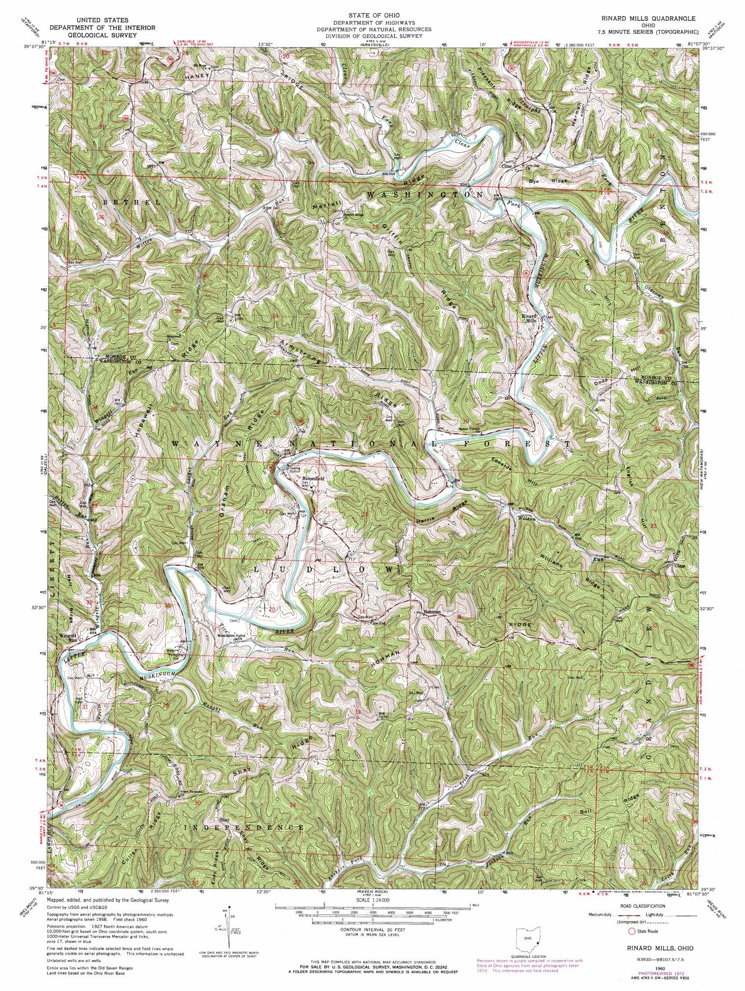
USGS Topo Quad 39081e2 - 1:24,000 scale
| Topo Map Name: | Rinard Mills |
| USGS Topo Quad ID: | 39081e2 |
| Print Size: | ca. 21 1/4" wide x 27" high |
| Southeast Coordinates: | 39.5° N latitude / 81.125° W longitude |
| Map Center Coordinates: | 39.5625° N latitude / 81.1875° W longitude |
| U.S. State: | OH |
| Filename: | o39081e2.jpg |
| Download Map JPG Image: | Rinard Mills topo map 1:24,000 scale |
| Map Type: | Topographic |
| Topo Series: | 7.5´ |
| Map Scale: | 1:24,000 |
| Source of Map Images: | United States Geological Survey (USGS) |
| Alternate Map Versions: |
Rinard Mills OH 1960, updated 1961 Download PDF Buy paper map Rinard Mills OH 1960, updated 1961 Download PDF Buy paper map Rinard Mills OH 1960, updated 1973 Download PDF Buy paper map Rinard Mills OH 1994, updated 1998 Download PDF Buy paper map Rinard Mills OH 2002, updated 2006 Download PDF Buy paper map Rinard Mills OH 2011 Download PDF Buy paper map Rinard Mills OH 2013 Download PDF Buy paper map Rinard Mills OH 2016 Download PDF Buy paper map |
| FStopo: | US Forest Service topo Rinard Mills is available: Download FStopo PDF Download FStopo TIF |
1:24,000 Topo Quads surrounding Rinard Mills
Sarahsville |
Summerfield |
Lewisville |
Woodsfield |
Cameron |
Macksburg |
Stafford |
Graysville |
Antioch |
Round Bottom |
Lower Salem |
Dalzell |
Rinard Mills |
New Matamoras |
Paden City |
Marietta |
Belmont |
Raven Rock |
Bens Run |
Middlebourne |
Valley Mills |
Willow Island |
Schultz |
Ellenboro |
Pennsboro |
> Back to 39081e1 at 1:100,000 scale
> Back to 39080a1 at 1:250,000 scale
> Back to U.S. Topo Maps home
Rinard Mills topo map: Gazetteer
Rinard Mills: Bridges
Knowlton Bridge elevation 207m 679′Rinard Covered Bridge elevation 196m 643′
Rinard Mills: Forests
Wayne National Forest - Athens Ranger District - Marietta Unit elevation 230m 754′Rinard Mills: Populated Places
Bloomfield elevation 211m 692′Carter (historical) elevation 214m 702′
Cline elevation 233m 764′
Cross Keys (historical) elevation 319m 1046′
Glass elevation 328m 1076′
Hohman elevation 344m 1128′
Muskingum (historical) elevation 212m 695′
Quarry (historical) elevation 236m 774′
Rinard Mills elevation 209m 685′
Shay elevation 331m 1085′
Ward (historical) elevation 321m 1053′
Wingett Run elevation 200m 656′
Rinard Mills: Post Offices
Cline Post Office (historical) elevation 242m 793′Crosskeys Post Office (historical) elevation 311m 1020′
Quarry Post Office (historical) elevation 237m 777′
Rinard Mills: Ridges
Armstrong Ridge elevation 299m 980′Cullen Ridge elevation 336m 1102′
Dye Ridge elevation 291m 954′
Graham Ridge elevation 318m 1043′
Griffin Ridge elevation 317m 1040′
Haney Ridge elevation 324m 1062′
Harris Ridge elevation 322m 1056′
Hohman Ridge elevation 338m 1108′
Hopewell Ridge elevation 331m 1085′
Merrell Ridge elevation 317m 1040′
Neff Ridge elevation 262m 859′
Shay Ridge elevation 334m 1095′
Williams Ridge elevation 327m 1072′
Rinard Mills: Streams
Boston Run elevation 209m 685′Clear Fork Little Muskingum River elevation 207m 679′
Haught Run elevation 197m 646′
Irish Run elevation 225m 738′
Jackson Run elevation 226m 741′
Oldcamp Run elevation 206m 675′
Sacket Run elevation 198m 649′
Straight Fork elevation 203m 666′
Tice Run elevation 200m 656′
Wilson Run elevation 206m 675′
Wingett Run elevation 195m 639′
Witten Run elevation 213m 698′
Rinard Mills: Summits
Bell Hill elevation 321m 1053′Dodd Hill elevation 334m 1095′
Edwards Hill elevation 309m 1013′
English Hill elevation 323m 1059′
Rinard Mills digital topo map on disk
Buy this Rinard Mills topo map showing relief, roads, GPS coordinates and other geographical features, as a high-resolution digital map file on DVD:
 map DVD")