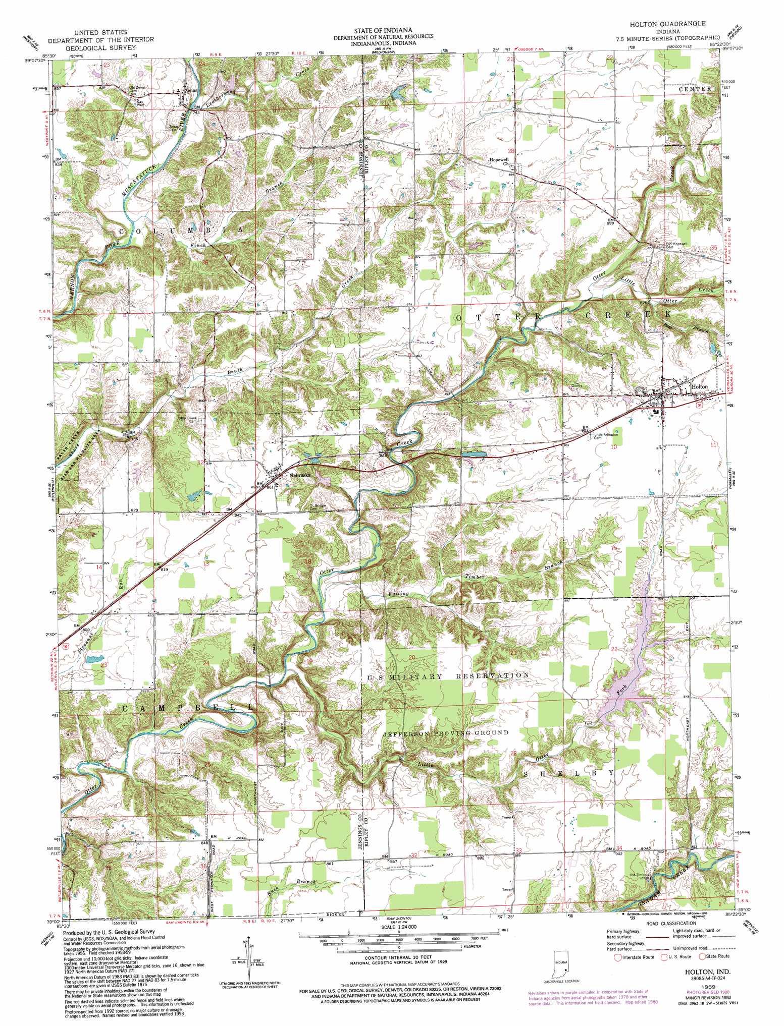
Holton Topo Map Indiana
To zoom in, hover over the map of Holton
USGS Topo Quad 39085a4 - 1:24,000 scale
| Topo Map Name: | Holton |
| USGS Topo Quad ID: | 39085a4 |
| Print Size: | ca. 21 1/4" wide x 27" high |
| Southeast Coordinates: | 39° N latitude / 85.375° W longitude |
| Map Center Coordinates: | 39.0625° N latitude / 85.4375° W longitude |
| U.S. State: | IN |
| Filename: | o39085a4.jpg |
| Download Map JPG Image: | Holton topo map 1:24,000 scale |
| Map Type: | Topographic |
| Topo Series: | 7.5´ |
| Map Scale: | 1:24,000 |
| Source of Map Images: | United States Geological Survey (USGS) |
| Alternate Map Versions: |
Holton IN 1959, updated 1960 Download PDF Buy paper map Holton IN 1959, updated 1976 Download PDF Buy paper map Holton IN 1959, updated 1981 Download PDF Buy paper map Holton IN 1959, updated 1993 Download PDF Buy paper map Holton IN 2010 Download PDF Buy paper map Holton IN 2013 Download PDF Buy paper map Holton IN 2016 Download PDF Buy paper map |
1:24,000 Topo Quads surrounding Holton
Hartsville |
Forest Hill |
Greensburg |
New Point |
Batesville |
Grammer |
Westport |
Millhousen |
Osgood |
Pierceville |
North Vernon |
Butlerville |
Holton |
Versailles |
Milan |
Hayden |
Vernon |
San Jacinto |
Rexville |
Cross Plains |
Deputy |
Volga |
Clifty Falls |
Canaan |
Bennington |
> Back to 39085a1 at 1:100,000 scale
> Back to 39084a1 at 1:250,000 scale
> Back to U.S. Topo Maps home
Holton topo map: Gazetteer
Holton: Dams
Leatherwood Lake Dam elevation 231m 757′Old Timber Lake Dam elevation 267m 875′
Holton: Parks
Brush Creek State Fish and Wildlife Area elevation 220m 721′Old Timbers Lodge elevation 268m 879′
Holton: Populated Places
Holton elevation 277m 908′Jackson elevation 243m 797′
Nebraska elevation 260m 853′
Zenas elevation 240m 787′
Holton: Reservoirs
Old Timber Lake elevation 267m 875′Holton: Streams
Bear Branch elevation 249m 816′Falling Timber Branch elevation 225m 738′
Finch Branch elevation 221m 725′
Leatherwood Creek elevation 222m 728′
Little Otter Creek elevation 244m 800′
Little Otter Fork elevation 222m 728′
Sugar Creek elevation 222m 728′
Holton digital topo map on disk
Buy this Holton topo map showing relief, roads, GPS coordinates and other geographical features, as a high-resolution digital map file on DVD:
Northern Illinois, Northern Indiana & Southwestern Michigan
Buy digital topo maps: Northern Illinois, Northern Indiana & Southwestern Michigan