Columbus Topo Map Indiana
To zoom in, hover over the map of Columbus
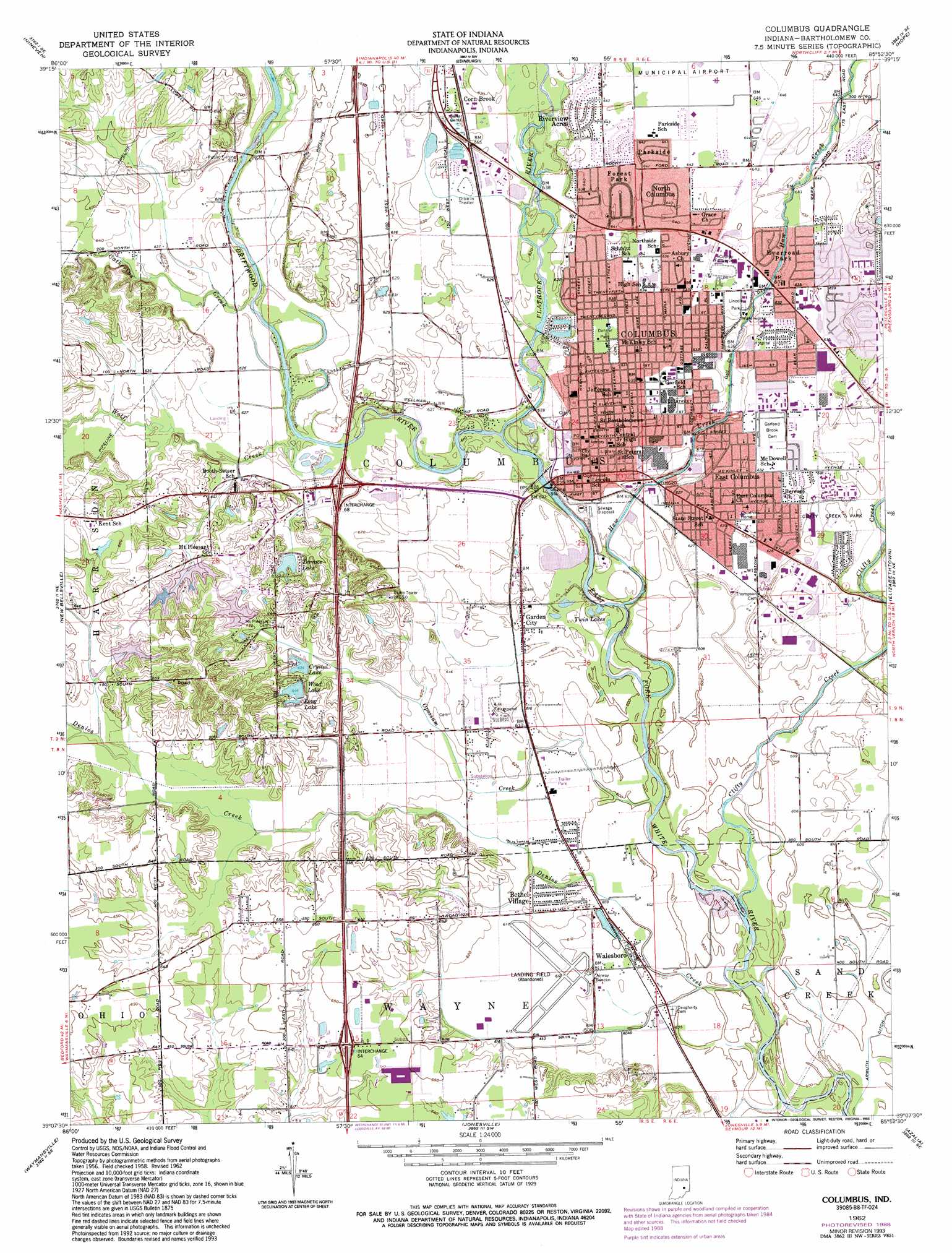
USGS Topo Quad 39085b8 - 1:24,000 scale
| Topo Map Name: | Columbus |
| USGS Topo Quad ID: | 39085b8 |
| Print Size: | ca. 21 1/4" wide x 27" high |
| Southeast Coordinates: | 39.125° N latitude / 85.875° W longitude |
| Map Center Coordinates: | 39.1875° N latitude / 85.9375° W longitude |
| U.S. State: | IN |
| Filename: | o39085b8.jpg |
| Download Map JPG Image: | Columbus topo map 1:24,000 scale |
| Map Type: | Topographic |
| Topo Series: | 7.5´ |
| Map Scale: | 1:24,000 |
| Source of Map Images: | United States Geological Survey (USGS) |
| Alternate Map Versions: |
Columbus IN 1958, updated 1959 Download PDF Buy paper map Columbus IN 1962, updated 1964 Download PDF Buy paper map Columbus IN 1962, updated 1970 Download PDF Buy paper map Columbus IN 1962, updated 1981 Download PDF Buy paper map Columbus IN 1962, updated 1984 Download PDF Buy paper map Columbus IN 1962, updated 1988 Download PDF Buy paper map Columbus IN 1962, updated 1993 Download PDF Buy paper map Columbus IN 2010 Download PDF Buy paper map Columbus IN 2013 Download PDF Buy paper map Columbus IN 2016 Download PDF Buy paper map |
1:24,000 Topo Quads surrounding Columbus
Trafalgar |
Franklin |
Marietta |
Lewis Creek |
Waldron |
Beanblossom |
Nineveh |
Edinburgh |
Hope |
Hartsville |
Nashville |
New Bellsville |
Columbus |
Elizabethtown |
Grammer |
Story |
Waymansville |
Jonesville |
Azalia |
North Vernon |
Kurtz |
Brownstown |
Seymour |
Chestnut Ridge |
Hayden |
> Back to 39085a1 at 1:100,000 scale
> Back to 39084a1 at 1:250,000 scale
> Back to U.S. Topo Maps home
Columbus topo map: Gazetteer
Columbus: Airports
Bartholomew County Hospital Airport elevation 191m 626′Columbus: Canals
Armuth Ditch elevation 182m 597′Columbus: Dams
Terrace Lake Dam elevation 198m 649′Columbus: Lakes
Long Lake elevation 199m 652′Twin Lakes elevation 185m 606′
Wood Lake elevation 197m 646′
Columbus: Parks
Clifty Creek Park elevation 189m 620′Donner Park elevation 192m 629′
Lincoln Park elevation 194m 636′
Columbus: Populated Places
Bethel Village elevation 186m 610′Columbus elevation 192m 629′
Corn Brook elevation 192m 629′
East Columbus elevation 191m 626′
Everroad Park elevation 194m 636′
Forest Park elevation 195m 639′
Garden City elevation 186m 610′
North Columbus elevation 195m 639′
Parkside elevation 195m 639′
Riverview Acres elevation 195m 639′
Walesboro elevation 184m 603′
Columbus: Reservoirs
Crystal Lake elevation 195m 639′Terrace Lake elevation 198m 649′
Columbus: Streams
Catherine Creek elevation 189m 620′Clifty Creek elevation 180m 590′
Denios Creek elevation 178m 583′
Driftwood River elevation 183m 600′
Flatrock River elevation 183m 600′
Haw Creek elevation 183m 600′
Opossum Creek elevation 183m 600′
Wolf Creek elevation 186m 610′
Columbus digital topo map on disk
Buy this Columbus topo map showing relief, roads, GPS coordinates and other geographical features, as a high-resolution digital map file on DVD:
Northern Illinois, Northern Indiana & Southwestern Michigan
Buy digital topo maps: Northern Illinois, Northern Indiana & Southwestern Michigan