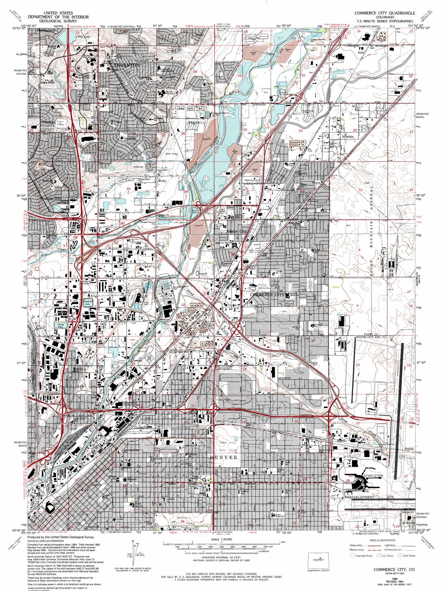
Commerce City Topo Map Colorado
To zoom in, hover over the map of Commerce City
USGS Topo Quad 39104g8 - 1:24,000 scale
| Topo Map Name: | Commerce City |
| USGS Topo Quad ID: | 39104g8 |
| Print Size: | ca. 21 1/4" wide x 27" high |
| Southeast Coordinates: | 39.75° N latitude / 104.875° W longitude |
| Map Center Coordinates: | 39.8125° N latitude / 104.9375° W longitude |
| U.S. State: | CO |
| Filename: | o39104g8.jpg |
| Download Map JPG Image: | Commerce City topo map 1:24,000 scale |
| Map Type: | Topographic |
| Topo Series: | 7.5´ |
| Map Scale: | 1:24,000 |
| Source of Map Images: | United States Geological Survey (USGS) |
| Alternate Map Versions: |
Derby CO 1938, updated 1955 Download PDF Buy paper map Derby CO 1950 Download PDF Buy paper map Derby CO 1957, updated 1958 Download PDF Buy paper map Derby CO 1957, updated 1958 Download PDF Buy paper map Derby CO 1957, updated 1961 Download PDF Buy paper map Commerce City CO 1965, updated 1967 Download PDF Buy paper map Commerce City CO 1965, updated 1969 Download PDF Buy paper map Commerce City CO 1965, updated 1973 Download PDF Buy paper map Commerce City CO 1965, updated 1973 Download PDF Buy paper map Commerce City CO 1965, updated 1980 Download PDF Buy paper map Commerce City CO 1965, updated 1994 Download PDF Buy paper map Commerce City CO 1965, updated 1994 Download PDF Buy paper map Commerce City CO 2010 Download PDF Buy paper map Commerce City CO 2013 Download PDF Buy paper map Commerce City CO 2016 Download PDF Buy paper map |
1:24,000 Topo Quads surrounding Commerce City
Niwot |
Erie |
Frederick |
Fort Lupton |
Hudson |
Louisville |
Lafayette |
Eastlake |
Brighton |
Mile High Lakes |
Golden |
Arvada |
Commerce City |
Sable |
Box Elder School |
Morrison |
Fort Logan |
Englewood |
Fitzsimons |
Coal Creek |
Indian Hills |
Littleton |
Highlands Ranch |
Parker |
Piney Creek |
> Back to 39104e1 at 1:100,000 scale
> Back to 39104a1 at 1:250,000 scale
> Back to U.S. Topo Maps home
Commerce City topo map: Gazetteer
Commerce City: Airports
Bulk Mail Center Heliport elevation 1589m 5213′Capri Heliport elevation 1602m 5255′
Galen Heliport elevation 1623m 5324′
General Mail Facility Heliport elevation 1592m 5223′
Public Service Company/MDC Heliport elevation 1558m 5111′
Regency Heliport elevation 1574m 5164′
Stapleton International Airport (historical) elevation 1607m 5272′
Commerce City: Canals
Burlington Ditch elevation 1558m 5111′Colorado Agricultural Canal elevation 1568m 5144′
O'Brian Canal elevation 1566m 5137′
Commerce City: Craters
Exit 219 elevation 1597m 5239′Commerce City: Crossings
Exit 1 elevation 1568m 5144′Exit 10 elevation 1559m 5114′
Exit 11 elevation 1555m 5101′
Exit 2 elevation 1577m 5173′
Exit 213 elevation 1581m 5187′
Exit 214 elevation 1579m 5180′
Exit 215 elevation 1588m 5209′
Exit 216 elevation 1572m 5157′
Exit 217 elevation 1577m 5173′
Exit 220 elevation 1643m 5390′
Exit 274 elevation 1579m 5180′
Exit 275A elevation 1580m 5183′
Exit 275B elevation 1582m 5190′
Exit 275C elevation 1582m 5190′
Exit 276A elevation 1589m 5213′
Exit 276B elevation 1599m 5246′
Exit 277 elevation 1601m 5252′
Exit 278 elevation 1607m 5272′
Exit 279 elevation 1600m 5249′
Exit 4 elevation 1597m 5239′
Exit 5 elevation 1577m 5173′
Exit 6 elevation 1567m 5141′
Exit 8 elevation 1560m 5118′
Exit 9 elevation 1558m 5111′
Commerce City: Dams
Badding Dam elevation 1645m 5396′Copeland Dam elevation 1584m 5196′
Croke Lake Dam elevation 1645m 5396′
Dewey Number 1 Dam elevation 1590m 5216′
Niver Creek Detention Dam elevation 1608m 5275′
Storm Dam elevation 1588m 5209′
Commerce City: Lakes
Grasmer Lake elevation 1609m 5278′Commerce City: Mines
Albert Frei and Sons Sand and Gravel Pit elevation 1555m 5101′C and H Construction Company Pit elevation 1565m 5134′
Colorado-Wyoming Improvement Company Pit elevation 1571m 5154′
Cooley Gravel Company Pit elevation 1546m 5072′
Department of Wildlife Pit elevation 1572m 5157′
Fast Construction Company Pit elevation 1562m 5124′
Houston Construction Pit elevation 1566m 5137′
Jones Fine Sand Company Pit elevation 1580m 5183′
Kilgore-Atchinson Pit elevation 1562m 5124′
Mobile Pre-mix Concrete Incorporated Pit elevation 1548m 5078′
Northwestern Engineering Company Pit elevation 1569m 5147′
Pete Kiewit Sons Pit elevation 1574m 5164′
Pink Greenhouses Pit elevation 1556m 5104′
Sterling Pit elevation 1563m 5127′
Superior Sand and Gravel Company Pit elevation 1585m 5200′
Western Paving Company Pit elevation 1571m 5154′
Western Paving Company Pit elevation 1580m 5183′
Commerce City: Parks
Argo Park elevation 1570m 5150′Aspen Park elevation 1562m 5124′
City of Nairobi Park elevation 1609m 5278′
Clayton Park elevation 1616m 5301′
Cole Neighborhood Historic District elevation 1592m 5223′
Columbia Park elevation 1555m 5101′
Community Park elevation 1583m 5193′
Coors Field elevation 1585m 5200′
Curtis Park elevation 1590m 5216′
Curtis-Champa Streets Historic District elevation 1590m 5216′
Dunham Park elevation 1586m 5203′
Elyria Park elevation 1579m 5180′
Fairfax Park elevation 1567m 5141′
Fred Thomas Park elevation 1627m 5337′
Fuller Park elevation 1596m 5236′
Glenarm Place Historic Residential District (historical) elevation 1596m 5236′
Globeville Landing Park elevation 1572m 5157′
Lawson Park elevation 1595m 5232′
Lily Park elevation 1591m 5219′
Los Valientes Park elevation 1575m 5167′
Lower Downtown Historic District elevation 1583m 5193′
Martin Luther King Park elevation 1613m 5291′
Monaco Park elevation 1585m 5200′
Morrison Park elevation 1592m 5223′
Northstar Park elevation 1606m 5269′
Rotella Park elevation 1578m 5177′
Russell Square Park elevation 1589m 5213′
Saint Charles Place Park elevation 1586m 5203′
San Rafael Historic District elevation 1600m 5249′
Schafer Park elevation 1591m 5219′
Skyland Park elevation 1613m 5291′
Swansea Park elevation 1579m 5180′
Yorkborough Park elevation 1586m 5203′
Commerce City: Populated Places
Adams City elevation 1565m 5134′Commerce City elevation 1574m 5164′
Derby elevation 1563m 5127′
Dupont elevation 1568m 5144′
Federal Heights elevation 1613m 5291′
Five Points elevation 1594m 5229′
Irondale elevation 1567m 5141′
North Washington elevation 1583m 5193′
Quimby elevation 1580m 5183′
Rolla elevation 1554m 5098′
Sandown elevation 1608m 5275′
Thornton elevation 1631m 5351′
Utah Junction elevation 1593m 5226′
Welby elevation 1565m 5134′
Western Hills elevation 1601m 5252′
Commerce City: Post Offices
Park Hill Station Denver Post Office elevation 1613m 5291′Postal Bulk Mail Facility elevation 1588m 5209′
Stockyards Station Denver Post Office elevation 1581m 5187′
Commerce City: Reservoirs
Badding Reservoir elevation 1645m 5396′Copeland Lake elevation 1584m 5196′
Croke Lake elevation 1644m 5393′
Croke Reservoir Number 12 elevation 1645m 5396′
Dewey Lake elevation 1590m 5216′
Dewey Reservoir Number 1 elevation 1590m 5216′
Franklin Reservoir elevation 1589m 5213′
Niver Creek Detention Reservoir elevation 1608m 5275′
Storm Reservoir elevation 1588m 5209′
Commerce City: Streams
Clear Creek elevation 1556m 5104′Sand Creek elevation 1558m 5111′
Westerly Creek elevation 1604m 5262′
Commerce City digital topo map on disk
Buy this Commerce City topo map showing relief, roads, GPS coordinates and other geographical features, as a high-resolution digital map file on DVD: