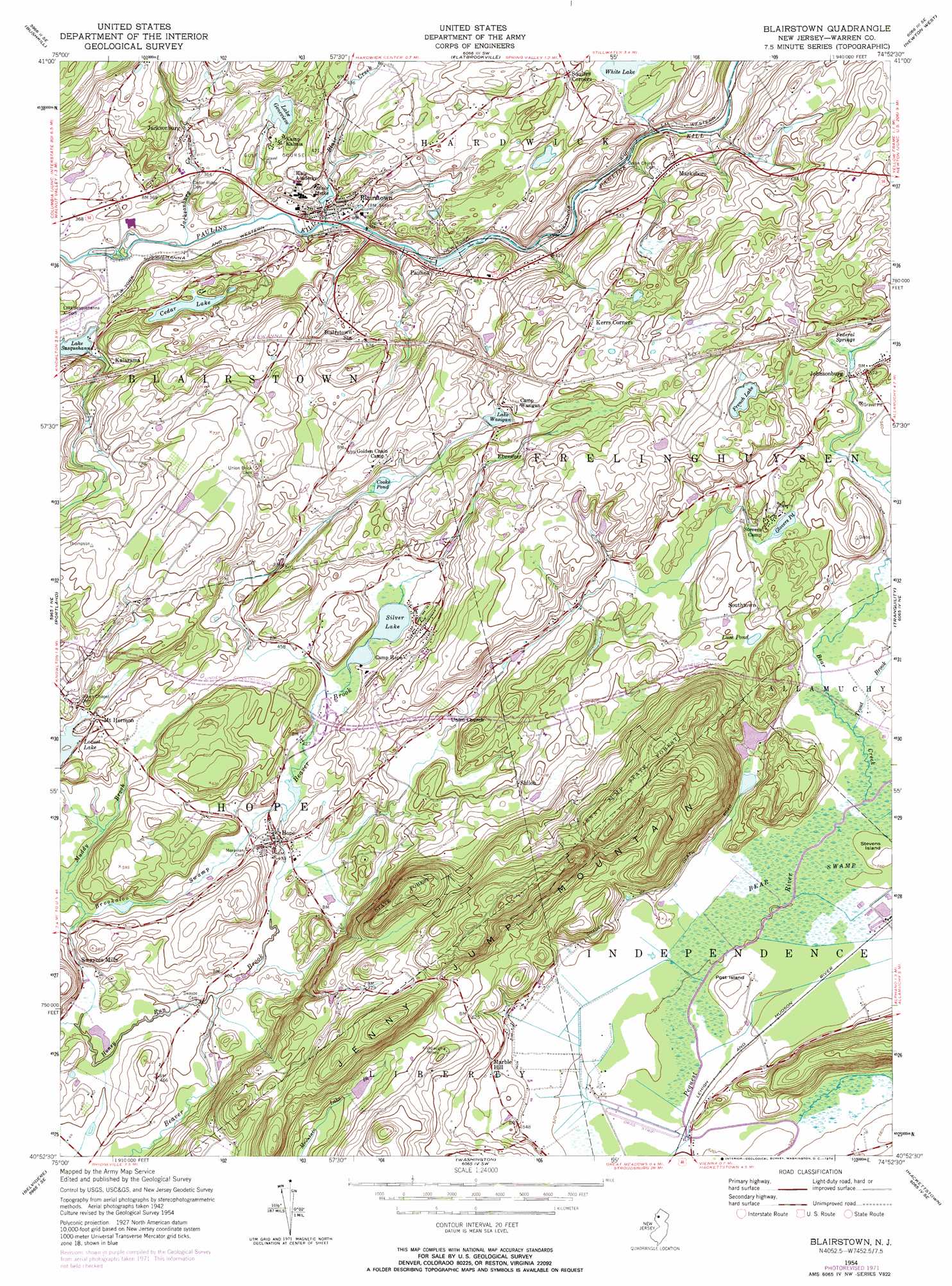
Blairstown Topo Map New Jersey
To zoom in, hover over the map of Blairstown
USGS Topo Quad 40074h8 - 1:24,000 scale
| Topo Map Name: | Blairstown |
| USGS Topo Quad ID: | 40074h8 |
| Print Size: | ca. 21 1/4" wide x 27" high |
| Southeast Coordinates: | 40.875° N latitude / 74.875° W longitude |
| Map Center Coordinates: | 40.9375° N latitude / 74.9375° W longitude |
| U.S. State: | NJ |
| Filename: | o40074h8.jpg |
| Download Map JPG Image: | Blairstown topo map 1:24,000 scale |
| Map Type: | Topographic |
| Topo Series: | 7.5´ |
| Map Scale: | 1:24,000 |
| Source of Map Images: | United States Geological Survey (USGS) |
| Alternate Map Versions: |
Blairstown NJ 1954, updated 1955 Download PDF Buy paper map Blairstown NJ 1954, updated 1962 Download PDF Buy paper map Blairstown NJ 1954, updated 1967 Download PDF Buy paper map Blairstown NJ 1954, updated 1974 Download PDF Buy paper map Blairstown NJ 2011 Download PDF Buy paper map Blairstown NJ 2014 Download PDF Buy paper map Blairstown NJ 2016 Download PDF Buy paper map |
1:24,000 Topo Quads surrounding Blairstown
Skytop |
Twelvemile Pond |
Lake Maskenozha |
Culvers Gap |
Branchville |
East Stroudsburg |
Bushkill |
Flatbrookville |
Newton West |
Newton East |
Stroudsburg |
Portland |
Blairstown |
Tranquility |
Stanhope |
Bangor |
Belvidere |
Washington |
Hackettstown |
Chester |
Easton |
Bloomsbury |
High Bridge |
Califon |
Gladstone |
> Back to 40074e1 at 1:100,000 scale
> Back to 40074a1 at 1:250,000 scale
> Back to U.S. Topo Maps home
Blairstown topo map: Gazetteer
Blairstown: Airports
Blairstown Airport elevation 114m 374′Darst Heliport elevation 152m 498′
High Meadow Farms Airport elevation 185m 606′
McDonoughs Heliport elevation 156m 511′
Blairstown: Dams
Blair Lake Dam elevation 108m 354′French Lake Dam elevation 210m 688′
Hope Lake Dam elevation 129m 423′
Lake Kalmia Dam elevation 122m 400′
Paulina Lake Dam elevation 103m 337′
Blairstown: Forests
Jenny Jump State Forest elevation 289m 948′Blairstown: Lakes
Cedar Lake elevation 118m 387′French Lake elevation 210m 688′
Glovers Pond elevation 172m 564′
Lake Genevieve elevation 122m 400′
Luse Pond elevation 181m 593′
Silver Lake elevation 134m 439′
White Lake elevation 135m 442′
Blairstown: Mines
Kishpaugh Mines elevation 234m 767′Blairstown: Populated Places
Blairstown elevation 108m 354′Ebenezer elevation 198m 649′
Febletown elevation 135m 442′
Hope elevation 140m 459′
Jacksonburg elevation 117m 383′
Johnsonburg elevation 176m 577′
Kalarama elevation 134m 439′
Marble Hill elevation 186m 610′
Marksboro elevation 152m 498′
Mount Hermon elevation 153m 501′
Paulina elevation 111m 364′
Shiloh elevation 158m 518′
Southtown elevation 191m 626′
Swayzes Mills elevation 128m 419′
Blairstown: Post Offices
Blairstown Post Office elevation 108m 354′Hope Post Office elevation 138m 452′
Johnsonburg Post Office elevation 176m 577′
Blairstown: Reservoirs
Blair Lake elevation 108m 354′Cooks Pond elevation 167m 547′
Hope Lake elevation 129m 423′
Lake Wasigan elevation 173m 567′
Paulina Lake elevation 103m 337′
Blairstown: Springs
Federal Springs elevation 169m 554′Blairstown: Streams
Bear Brook elevation 162m 531′Bear Creek elevation 162m 531′
Blair Creek elevation 102m 334′
Brookaloo Swamp elevation 130m 426′
Honey Run elevation 117m 383′
Jacksonburg Creek elevation 96m 314′
Muddy Brook elevation 121m 396′
Trout Brook elevation 164m 538′
Trout Brook elevation 124m 406′
Blairstown: Summits
Jenny Jump Mountain elevation 344m 1128′Post Island elevation 169m 554′
Stevens Island elevation 171m 561′
Blairstown digital topo map on disk
Buy this Blairstown topo map showing relief, roads, GPS coordinates and other geographical features, as a high-resolution digital map file on DVD:
Atlantic Coast (NY, NJ, PA, DE, MD, VA, NC)
Buy digital topo maps: Atlantic Coast (NY, NJ, PA, DE, MD, VA, NC)
 map DVD")