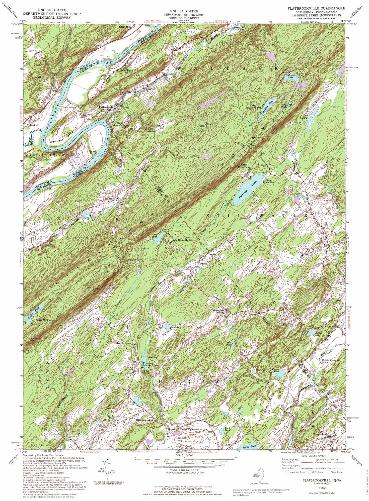
Flatbrookville Topo Map New Jersey
To zoom in, hover over the map of Flatbrookville
USGS Topo Quad 41074a8 - 1:24,000 scale
| Topo Map Name: | Flatbrookville |
| USGS Topo Quad ID: | 41074a8 |
| Print Size: | ca. 21 1/4" wide x 27" high |
| Southeast Coordinates: | 41° N latitude / 74.875° W longitude |
| Map Center Coordinates: | 41.0625° N latitude / 74.9375° W longitude |
| U.S. States: | NJ, PA |
| Filename: | o41074a8.jpg |
| Download Map JPG Image: | Flatbrookville topo map 1:24,000 scale |
| Map Type: | Topographic |
| Topo Series: | 7.5´ |
| Map Scale: | 1:24,000 |
| Source of Map Images: | United States Geological Survey (USGS) |
| Alternate Map Versions: |
Flatbrookville NJ 1954, updated 1955 Download PDF Buy paper map Flatbrookville NJ 1954, updated 1961 Download PDF Buy paper map Flatbrookville NJ 1954, updated 1967 Download PDF Buy paper map Flatbrookville NJ 1954, updated 1974 Download PDF Buy paper map Flatbrookville NJ 1976, updated 1978 Download PDF Buy paper map Flatbrookville NJ 1992, updated 1995 Download PDF Buy paper map Flatbrookville NJ 1997, updated 1998 Download PDF Buy paper map Flatbrookville NJ 2011 Download PDF Buy paper map Flatbrookville NJ 2014 Download PDF Buy paper map Flatbrookville NJ 2016 Download PDF Buy paper map |
1:24,000 Topo Quads surrounding Flatbrookville
Promised Land |
Pecks Pond |
Edgemere |
Milford |
Port Jervis South |
Skytop |
Twelvemile Pond |
Lake Maskenozha |
Culvers Gap |
Branchville |
East Stroudsburg |
Bushkill |
Flatbrookville |
Newton West |
Newton East |
Stroudsburg |
Portland |
Blairstown |
Tranquility |
Stanhope |
Bangor |
Belvidere |
Washington |
Hackettstown |
Chester |
> Back to 41074a1 at 1:100,000 scale
> Back to 41074a1 at 1:250,000 scale
> Back to U.S. Topo Maps home
Flatbrookville topo map: Gazetteer
Flatbrookville: Bends
Wallpack Bend elevation 124m 406′Wallpack Bend elevation 92m 301′
Flatbrookville: Dams
Bass Lake Dam elevation 231m 757′Hemlock Lake Dam elevation 362m 1187′
Lake Kathyrn Dam elevation 288m 944′
Lake Plymouth Dam elevation 301m 987′
Lake Success Dam elevation 410m 1345′
Lower Blue Mountain Lake Dam elevation 335m 1099′
Spring Valley Dam elevation 136m 446′
Upper Blue Mountain Lake Dam elevation 337m 1105′
Youngs Pond Dam elevation 209m 685′
Flatbrookville: Falls
Bass Lake Falls elevation 226m 741′Flatbrookville: Islands
Sambo Island elevation 98m 321′Flatbrookville: Lakes
Catfish Pond elevation 136m 446′Crater Lake elevation 411m 1348′
Dry Pond elevation 444m 1456′
Duck Pond elevation 146m 479′
Fairview Lake elevation 276m 905′
Lake Kathryn elevation 288m 944′
Meadows Lake elevation 274m 898′
Mud Pond elevation 151m 495′
Sand Pond elevation 294m 964′
Shuster Pond elevation 136m 446′
Turtle Pond elevation 244m 800′
Flatbrookville: Populated Places
Flatbrookville elevation 103m 337′Franklin Grove elevation 261m 856′
Hardwick elevation 259m 849′
Hardwick Center elevation 166m 544′
Millbrook elevation 199m 652′
Spring Valley elevation 140m 459′
Stillwater elevation 139m 456′
Flatbrookville: Reservoirs
Bass Lake elevation 231m 757′Blue Mountain Lakes elevation 335m 1099′
Hemlock Lake elevation 362m 1187′
Lake Plymouth elevation 301m 987′
Lake Success elevation 410m 1345′
Long Pine Pond elevation 389m 1276′
Lower Blue Mountain Lake elevation 335m 1099′
Mountain Ridge Lake elevation 344m 1128′
Spring Valley Lake elevation 136m 446′
Upper Blue Mountain Lake elevation 337m 1105′
Youngs Pond elevation 209m 685′
Flatbrookville: Streams
Bush Kill elevation 98m 321′Flat Brook elevation 98m 321′
Toms Creek elevation 100m 328′
Flatbrookville digital topo map on disk
Buy this Flatbrookville topo map showing relief, roads, GPS coordinates and other geographical features, as a high-resolution digital map file on DVD:
New York, Vermont, Connecticut & Western Massachusetts
Buy digital topo maps: New York, Vermont, Connecticut & Western Massachusetts